
Montenescourt
- العربية
- Asturianu
- 閩南語 / Bân-lâm-gú
- Brezhoneg
- Català
- Cebuano
- Čeština
- Deutsch
- Eesti
- Español
- Euskara
- Français
- Bahasa Indonesia
- Italiano
- Қазақша
- Kurdî
- Latina
- Lëtzebuergesch
- Magyar
- Malagasy
- مصرى
- Bahasa Melayu
- Nederlands
- Нохчийн
- Occitan
- Picard
- Piemontèis
- Polski
- Português
- Română
- Simple English
- Slovenčina
- Svenska
- Татарча / tatarça
- Українська
- Vèneto
- Tiếng Việt
- Winaray
- Zazaki
- 中文
From Wikipedia, the free encyclopedia
This is an old revision of this page, as edited by Markussep (talk | contribs) at 11:52, 15 May 2020 (rm unspecific archived external link). The present address (URL) is a permanent link to this revision, which may differ significantly from the current revision.
Commune in Hauts-de-France, France
Montenescourt | |
|---|---|
 The church of Montenescourt | |
 Coat of arms | |
Location of Montenescourt  | |
 Montenescourt  Montenescourt | |
| Coordinates: 50°17′36″N 2°37′31″E / 50.2933°N 2.6253°E / 50.2933; 2.6253 | |
| Country | France |
| Region | Hauts-de-France |
| Department | Pas-de-Calais |
| Arrondissement | Arras |
| Canton | Avesnes-le-Comte |
| Intercommunality | CC Campagnes de l'Artois |
| Government | |
| • Mayor (2008–2014) | Bernard Libessart |
| Area 1 | 5.08 km2 (1.96 sq mi) |
| Population (2021)[1] | 445 |
| • Density | 88/km2 (230/sq mi) |
| Time zone | UTC+01:00 (CET) |
| • Summer (DST) | UTC+02:00 (CEST) |
| INSEE/Postal code | 62586 /62123 |
| Elevation | 76–127 m (249–417 ft) (avg. 83 m or 272 ft) |
| 1 French Land Register data, which excludes lakes, ponds, glaciers > 1 km2 (0.386 sq mi or 247 acres) and river estuaries. | |
Montenescourt is a commune in the Pas-de-Calais department in the Hauts-de-France region of France.
Geography
Montenescourt is situated 7 miles (11 km) west of Arras, at the junction of the D61 and the D56 roads.
Population
| 1962 | 1968 | 1975 | 1982 | 1990 | 1999 | 2006 |
|---|---|---|---|---|---|---|
| 137 | 153 | 227 | 362 | 418 | 408 | 431 |
| Census count starting from 1962: Population without duplicates | ||||||
Places of interest
- The church of St.Leger, dating from the seventeenth century.
See also
References
- ^ "Populations légales 2021". The National Institute of Statistics and Economic Studies. 28 December 2023.
Wikimedia Commons has media related to Montenescourt.
-
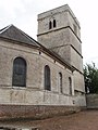 The church
 -
 The war memorial


| Authority control databases: National |
|---|
This Arras arrondissement, Pas-de-Calais geographical article is a stub. You can help Wikipedia by expanding it. |
Hidden categories:
- Articles with short description
- Short description is different from Wikidata
- Coordinates on Wikidata
- Pages using infobox settlement with image map1 but not image map
- Commons category link from Wikidata
- Articles with BNF identifiers
- Articles with BNFdata identifiers
- All stub articles
- Pages using the Kartographer extension