Sahtu Region
Sahtu Region | |
|---|---|
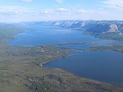
 Norman Range and Kelly Lake | |
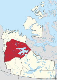
 Location within the Northwest Territories | |
| Country | Canada |
| Territory | Northwest Territories |
| Federal riding | Northwest Territories |
| Territorial riding | Sahtu |
| Government | |
| • Office location | Norman Wells |
| Population (2016) | |
| • Total | 2,554 |
| Time zone | UTC−07:00 (MST) |
| • Summer (DST) | UTC−06:00 (DST) |
The Sahtu Region is an administrative region in Canada's Northwest Territories. Coterminous with the settlement region described in the 1993 Sahtu Dene and Metis Comprehensive Land Claim Agreement, 41,437 km2 (15,999 sq mi) of the Sahtu is collectively owned by its Indigenous Sahtu (Dene) and Métis inhabitants. Although the region's population is predominantly First Nations, a significant non-Indigenous presence exists in the regional capital of Norman Wells, established in 1920 to serve the only producing oilfield in the Canadian Territories. Considered to be of vital strategic importance during World War II in the event of a Japanese invasion of Alaska, the region's petroleum resources were exploited by the United States Army with the Canol pipeline, but the project never became necessary and ultimately operated for less than one year.
Since the abandonment of the Canol project, development within the region has been more limited than in the rest of the territory. Although plans have long existed for pipelines and highways to parallel the Mackenzie River through the Sahtu en route to the Arctic Ocean, the landmark Mackenzie Valley Pipeline Inquiry recommended that a moratorium be placed on construction until local Indigenous land claims could be settled. To this day, no all-weather roads connect the Sahtu with the rest of Canada, and the contiguous North American pipeline network finds its northernmost terminus at Norman Wells, which was connected to Zama City, Alberta in 1984. Ground transportation is seasonally provided by a network of winter and ice roads, while the abandoned Canol route now forms part of the Trans Canada Trail system.[2]

Etymology
Sahtú is the Dene name of Great Bear Lake, the largest lake entirely in Canada, which is entirely contained within the Sahtu Region. The name is also used by the area's First Nations inhabitants to describe themselves and their language, the Sahtú Dene people (historically known as the North Slavey or Hareskins).[3] It has been further adopted by the Sahtu Dene Council and the Sahtu Secretariat, both Indigenous institutions which share administrative responsibilities with the Government of the Northwest Territories within the region.
Communities
The Sahtu Region consists of five communities, with no permanent population recorded outside their boundaries. Norman Wells, the regional capital, was founded in the early 20th century in order to exploit local oil deposits and has a majority non-Indigenous population. The other communities of the Sahtu are predominantly First Nations.
| Community | Demographics (2016) | ||||||
|---|---|---|---|---|---|---|---|
| Name[4] | Type[5] | Census[6] | Aboriginal population profile[7] | ||||
| Official | Traditional | Total | First Nations | Métis | Inuit | Other | |
| Colville Lake | K'áhbamı̨́túé | Settlement Corporation | 129 | 105 | 0 | 0 | 25 |
| Deline | Délı̨ne | Charter Community | 533 | 490 | 25 | 15 | 75 |
| Fort Good Hope | Rádeyı̨lı̨kóé | Charter Community | 516 | 430 | 35 | 30 | 130 |
| Norman Wells | Tłegǫ́htı̨ | Town | 778 | 250 | 70 | 25 | 560 |
| Tulita | Tulı́t’a | Hamlet | 477 | 325 | 55 | 0 | 135 |

|
| |||||||||||||||||||||||||||||||||||||||||||||||||||||||||
| Sources: NWT Bureau of Statistics (2001 - 2017)[8] | ||||||||||||||||||||||||||||||||||||||||||||||||||||||||||
References
- ^ Government of the Northwest Territories. "About Municipal and Community Affairs". Retrieved 2019-06-17.
- ^ The Sahtu Atlas. Sahtu Settlement Region, Northwest Territories. 2005. ISBN 0-9737630-0-0.
{{cite book}}: CS1 maint: location missing publisher (link) - ^ The Sahtu Atlas. Sahtu Settlement Region, Northwest Territories. 2005. p. 5. ISBN 0-9737630-0-0.
{{cite book}}: CS1 maint: location missing publisher (link) - ^ "Northwest Territories Official Community Names and Pronunciation Guide". Prince of Wales Northern Heritage Centre. Yellowknife: Education, Culture and Employment, Government of the Northwest Territories. Archived from the original on 2016-01-13. Retrieved 2016-01-13.
- ^ "Differences in Community Government Structures" (PDF). Maca.gov.nt.ca. Retrieved 18 December 2014.
- ^ "Population and dwelling counts, for Canada, provinces and territories, and census subdivisions (municipalities), 2016 and 2011 censuses – 100% data".
- ^ "Aboriginal Population Profile, 2016 census". Statistics Canada. Retrieved 1 July 2019.
- ^ Population Estimates By Community from the GNWT

