Bajram Curri (town)
Bajram Curri | |
|---|---|
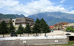
 City Center of Bajram Curri | |
| Coordinates: 42°21′N 20°5′E / 42.350°N 20.083°E | |
| Country | |
| County | Kukës |
| Municipality | Tropojë |
| Population (2011) | |
| • Municipal unit | 5,340 |
| Time zone | UTC+1 (CET) |
| • Summer (DST) | UTC+2 (CEST) |
| Area Code | 0213 |

Bajram Curri[1] is a town situated in northern of Albania, near the border with Kosovo[a], in a remote, mostly mountainous region. The town is named after Bajram Curri, a national hero who fought for ethnic Albanians, first against the Ottoman Empire and later against the Albanian government. It is the center of Tropoja District. The town is located in the Valbonë Valley and is the main access point by road to touristic sights and villages of Valbona located in the Prokletije mountains. Bajram Curri is the gateway to Valbona Valley and Lake Koman, both of which are must-sees while in the Kukës Region.
History
Bajram Curri was founded in the year 1957 to serve as the centre of the district of Tropoja. The village was previously known as Kolgecaj. The newly formed city was build based on socialist principles.
Geography
Bajram Curri is located down the valley of the river Valbonë. It is the main access point by road to the villages of Valbona and Rrogam. Water from the mountains flow into the waters of the Valbonë, then latter being famous for having the clearest river water in Albania.
At the 2015 local government reform it became a subdivision and the seat of the municipality Tropojë.[2]
Demographics
The population at the 2011 census was 5,340.[3]
Economy
Tropojë has many agricultural products and is famous for its chestnuts, apples, nuts, grapes, and especially blueberries. Large reserves of platinum, rhodium, ruthenium, palladium, iridium, and osmium have been discovered in Tropojë. Albanian, Italian, and Chinese engineers, working for Albanian Minerals and Bytyci Sh.p.k in Tropojë, suggest the area may have more than 500 million tons of chrome ore and more than two billion tons of olivine in which platinum is 5-7 grams present per ton. This gigantic body of ore is one of the largest in the world.
Climate
Bajram Curri has a humid subtropical climate (Köppen climate classification: Cfa).
| Climate data for Bajram Curri | |||||||||||||
|---|---|---|---|---|---|---|---|---|---|---|---|---|---|
| Month | Jan | Feb | Mar | Apr | May | Jun | Jul | Aug | Sep | Oct | Nov | Dec | Year |
| Mean daily maximum °C (°F) | 4.9 (40.8) |
7.5 (45.5) |
12.2 (54.0) |
16.9 (62.4) |
21.9 (71.4) |
25.8 (78.4) |
28.5 (83.3) |
28.5 (83.3) |
24.3 (75.7) |
17.8 (64.0) |
11.2 (52.2) |
6.7 (44.1) |
17.2 (62.9) |
| Daily mean °C (°F) | 1.6 (34.9) |
3.7 (38.7) |
7.6 (45.7) |
11.9 (53.4) |
16.5 (61.7) |
20.3 (68.5) |
22.6 (72.7) |
22.4 (72.3) |
18.5 (65.3) |
13.0 (55.4) |
7.6 (45.7) |
3.5 (38.3) |
12.4 (54.4) |
| Mean daily minimum °C (°F) | −1.6 (29.1) |
−0.1 (31.8) |
3.1 (37.6) |
6.9 (44.4) |
11.1 (52.0) |
14.8 (58.6) |
16.7 (62.1) |
16.4 (61.5) |
12.8 (55.0) |
8.3 (46.9) |
4.1 (39.4) |
0.3 (32.5) |
7.7 (45.9) |
| Average precipitation mm (inches) | 126 (5.0) |
114 (4.5) |
106 (4.2) |
105 (4.1) |
93 (3.7) |
65 (2.6) |
52 (2.0) |
58 (2.3) |
92 (3.6) |
119 (4.7) |
154 (6.1) |
151 (5.9) |
1,235 (48.7) |
| Source: [4] | |||||||||||||
Notable people
- Sali Berisha - President of Albania from 1992 to 1997 and its Prime Minister from 2005 to 2013
- Zhaneta Byberi – Miss Universe Albania 2014
- Azem Hajdari – anti-Communist activist
- Besnik Mustafaj – 62nd Minister of Foreign Affairs of Albania
- Gerhard Progni – footballer
- Fatime Sokoli – folk singer
- Fatmira brecani - folk singer
- Ibrahim kadri malaj - intellectual
- Tahir sinani - commander,ushtria clirimtare kosoves (UÇK)
- Bajram Mal Gjongecaj -Intellectual, Trainer of sports, create and succeed first Most successful basketball club in Albania Called (Valbona)
Notes and references
Notes:
| a. | ^ Template:Kosovo-note |
- ^ "Bashkia Tropoje - Faqja Zyrtare". Bashkia Tropoje. Retrieved 2019-11-03.
- ^ "Law nr. 115/2014" (PDF). Archived from the original (PDF) on 2015-09-24. Retrieved 2015-06-12.
- ^ 2011 census results Archived 2016-03-04 at the Wayback Machine
- ^ "Climate: Bajram Curri". Climate-Data.org. Retrieved April 29, 2019.


