
Inverness-shire
Inverness-shire | |
|---|---|
 | |
| Country | Scotland |
| County town | Inverness |
| Area | |
| • Total | 4,211 sq mi (10,906 km2) |
| Ranked 1st of 34 | |
| Chapman code | INV |
The Shire of Inverness (Scottish Gaelic: Siorrachd Inbhir Nis) is a historic county, registration county and lieutenancy area of Scotland. Covering much of the Highlands and Outer Hebrides, it is Scotland's largest county, though one of the smallest in population, with 67,733 people or 1.34% of the Scottish population.[1]
Definition
The extent of the lieutenancy area was defined in 1975 as covering the districts of Inverness, Badenoch & Strathspey, and Lochaber.[citation needed] Thus it differs from the county in that it includes parts of what were once Moray and Banffshire, but does not include any of the Outer Hebrides which were given their own lieutenancy area — the Western Isles.[citation needed]
Geography


Inverness-shire is Scotland's largest county, and the second largest in the UK as a whole after Yorkshire. It borders Ross-shire to the north, Nairnshire, Moray, Banffshire and Aberdeenshire to the east, and Perthshire and Argyllshire to the south.
Its mainland section covers a large area of the Highlands, bordering the Sea of the Hebrides to the west and Beauly Firth and Moray Firth to the east which provide access to the North Sea. It is split into two by the Great Glen, a roughly 60 mile geological fault which runs south-west to north-east and divides the Northwest Highlands to the west from the Grampian Mountains (including the Monadhliath Mountains) to the east. The glen contain the notable lochs of Loch Ness (Scotland's second largest), Loch Oich and Loch Lochy, which are connected by the Caledonian Canal; it opens into the south-west into the sealoch Loch Linnhe. Ben Nevis, the tallest peak in Britain, is located to the east of Fort William. The west coast consists of a number of large peninsulas divided by long loch inlets; north-to-south these are Glenelg (shared with Ross-shire), Loch Hourn, Knoydart, Loch Nevis, North and South Morar/Arisaig, Loch nan Uamh, Ardnish, Loch Ailort, Moidart and Loch Moidart. This area was traditionally referred to as the Rough Bounds due to its remoteness and inaccessibility and it remains wild and sparseley populated today. The terrain in Inverness-shire is generally mountainous, with numerous lochs scattered throughout the county, the largest of these being: Loch Ashie, Loch Mhor, Loch Knockie, Loch Duntelchaig, Loch Ruthven, Loch Moy, Loch Alvie, Loch Insh, Loch an Eilean, Loch Killin, Loch Crunachdan, Loch Morlich, Loch Garten, Loch Einich, Loch an t-Seilich, Loch na Cuaich, Loch Coaldair, the Blackwater Reservoir, Loch Treig, Loch Ossian, Loch Laggan, Loch Spean, Loch Ericht, Loch Gulbin, Lochan na h-Earba, Loch Pattack, Loch Eilde Mòr, Loch a' Bhealaich Bheithe, Loch a' Bhealaich Leamhain, Lochan Lùnn Dà-Bhrà, Loch Bruicaich, Loch Meiklie, Loch ma Stac, Loch a' Chràthaich, Loch na Beinne Baine, Loch Lundie, Loch Garry, Loch Beannacharan, Loch Beinn a Mheadhoin, Loch Monar, Loch Mullardoch, Loch Affric, Loch Cluanie, Loch Loyne, Loch Quoich, Loch an Dubh-Lochain, Loch Arkaig, Loch Morar, Loch Beoriad, Loch Dhoire a' Ghearrain and Loch Shiel.
Inverness-shire contains numerous small islands off its west coast which form part of the Inner Hebrides. The largest of these is Skye, separated from the Inverness-shire mainland by the Sound of Sleat; popular with tourists, it is a huge, sprawling island - the second biggest in Scotland - containing numerous peninsulas and offshore islands. The small isle of Eigg is also within Inverness-shire, despite the other Small Isles being in Argyllshire. To the west, across the Little Minch, most of the Outer Hebrides fall within the county, with the notable exception of Lewis which is in Ross-shire. Further west still lie the remote islands of St Kilda, which have been uninhabited since 1930. Much further west, 230 miles from the Outer Hebrides, lies the extremely remote, uninhabitable island of Rockall, which is subject to a territorial dispute with Ireland.
Islands
- An t-Eilean Meadhoin
- Brinacory Island
- Eilean a' Ghiuthais
- Eilean a' Phidhir
- Eilean Bàn
- Eilean Choinneach
- Eilean nam Breac
Inner Hebrides
- Airor Island
- Am Bi-bogha Beag
- Am Bi-bogha Mhòr
- Am Bord (also known as Lord Macdonald's Table)
- Am Fraoch-eilean
- An Dubh-sgeir
- An Dubh Sgeir
- An Garbh-eilean
- An Glas Eilean
- An t-Iasgair
- Ascrib Islands
- Bogh Oitir
- Clac nan Ràmh
- The Cleats
- Clett
- Corr Eilean
- Cow Rock
- Dubh Sgeir
- Eigg
- Eilean a' Chaolais
- Eilean a' Choire
- Eilean a' Chuilinn
- Eilean a' Ghaill
- Ealean a' Gharb-làin
- Eilean a' Mhuineil
- Eilean a' Phiobaire
- Eilean Aigastan
- Eilean an Eòin
- Eilean an Fheidh
- Eilean an Fhraoich
- Eilean an Inbhire
- Eilean an Sgùrra
- Eilean a t-Sabhail
- Eilean an t-Snidhe
- Eilean Buidhe
- Eilean Chathastail
- Eilean Chlamail
- Eilean Coille
- Eilean Dà Chuain
- Eilean Dearg
- Eilean Fladday
- Eilean Gaineamhach Boreraig
- Eilean Garbh
- Eilean Ghiubhais
- Eilean Gobhlach
- Eilean Heast
- Eilean Ighe
- Eilean Maol
- Eilean Mhogh-sgeir
- Eilean Mòr
- Eilean na h-Àirde
- Eilean na h-Arcairseid
- Eilean na h-Oitire
- Eilean na Glaschoille
- Eilean nam Bairneach
- Eilean nan Cabar
- Eilean nan Gobhar
- Eilean nan Trom
- Eilean Port nam Murrach
- Eilean Ràrsaidh
- Eilean Raonuill
- Eilean Reamhar
- Eilean Ruairidh
- Eilean Seamraig
- Eilean Sgorach
- Eilean Shamadalain
- Eilean Shona
- Eilean Sionnach
- Eilean Thuilm
- Eilean Tigh
- Eilean Tioram (Loch Hourn)
- Eilean Tioram (Loch Nevis)
- Eilean Trodday
- Eileanan Dubha
- Fladda-chùain
- Flod Sgeir
- Gaeilavore Island
- Gairbh Eilein
- Garbh Eilean
- Gearran Island
- Glas Eilean
- Griana-sgeir
- Guillamon Island
- Harlosh Island
- Holoman Island
- Isay
- Lampay
- Longay
- Luinga Beag
- Luinga Mhòr
- Macleaod's Maidens
- Manish Island
- Meallan Odhar
- Mingay
- Na Gamhnachain
- Ornsay
- Oronsay
- Pabay
- Raasay
- Riska Island
- Roag Island
- Samalaman Island
- Sandaig Islands
- Scalpay
- Sgeir a' Chuain
- Sgeir a'Ghaill
- Sgeir an Fheòir
- Sgeir an t-Struith
- Sgeir Biodaig
- Sgeir Chnapach
- Sgeir Dhearg
- Sgeir Dorcha
- Sgeir Fhada
- Sgeir Ghainmheach
- Sgeir Ghlas
- Sgeir Gobhlach
- Sgeir Leathan
- Sgeir Mhòr
- Sgier na Caillich
- Sgeir na h-Éireann
- Sgeir nam Biast
- Sgeir nam Maol
- Sgeir nan Eilid
- Sgeir nan Ruideag
- Sgeir Shuas
- Sgeir Thraid
- Sgeirean Buidhe Bhorlum
- Sgeirean Dubha Fhiadhach
- Sgeirean Gobhlach
- Sgeirean Glasa
- Sgeirean Ràrsaidh
- Skye
- Soay
- South Rona
- Staffin Island
- Sula Skerry
- Tarner Island
- Tulm Island
- Wiay
-
 Coast of Eigg
 -
 Dùn Caan mountain on Raasay
 -
 Oronsay
 -
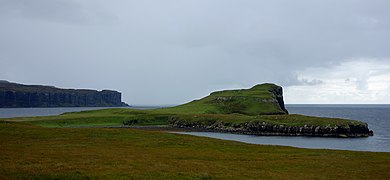
 Landscape of northern Skye


Outer Hebrides
- Baleshare
- Barra
- Barra Head (also known as Berneray)
- Bearran
- Benbecula
- Berneray
- Bhacasaigh
- Bhaiteam
- Bhatam
- Bhorogaigh
- Bhotarsaigh
- Bior-eilean
- Boreray
- Cafuam
- Caigionn
- Càiream
- Calabhagh
- Calbhaigh (multiple islands with this name)
- Callum More
- Caolaigh
- Causamul
- Ceallasaigh Beag
- Ceallasaigh Mòr
- Cearstaigh
- Cliasaigh Beag
- Cliasaigh Mòr
- Collam
- Copaigh
- Corr-eileanan
- Crago
- Craobaghan
- Creag na Staid
- Creag nan Sealladh
- Cuidhnis
- Cuidsgeir
- Deasgeir
- Dioraigh
- Dubh-Sgeir Mhòr
- Duisgeir (northern)
- Duisgeir (south-east)
- Duisgeir (south-west)
- Dùn Àrn
- Dùn Corr Mòr
- Eilean a' Bhogha
- Eilean a' Gheoidh
- Eilean a' Ghiorr
- Eilean a' Ghuail
- Eilean a' Mhadaidh
- Eilean a' Mhail
- Eilean a' Mhòrain
- Eilean Àird Rainis
- Eilean an Fhèidh
- Eilean an Fhraoich Miatha
- Eilean an Rubha
- Eilean Baile Gearraidh
- Eilean Bhàlaig
- Eilean Bheirean
- Eilean Chàirminis
- Eilean Chòdam
- Eilean Chrossain
- Eilean Chuidhtinis
- Eilean Cuithe nam Fiadh
- Eilean Direcleit
- Eilean Dubh Chollaim
- Eilean Dubh na Muice
- Eilean Fhionnlaidh
- Eilean Fhionnsabhaigh
- Eilean Fuam
- Eilean Iochdrach
- Eilean Leathan
- Eilean Lingreabhaigh
- Eilean Mhànais
- Eilean Mhàraig
- Eilean Mhiàthlais
- Eilean Mhic Caoilte
- Eilean Mhic Fhionnlaidh
- Eilean Mhidinis
- Eilean na Cille
- Eilean na Cloiche
- Eilean na h-Àirigh
- Eilean na Gearrabreac
- Eilean na Praise
- Eilean na Sgaite
- Eilean na Sgùirr
- Eilean nam Bridianach
- Eilean nan Carnan
- Eilean nan Each
- Eilean nan Gamhna
- Eilean nan Gearr
- Eilean nan Imireachean
- Eilean nan Mult
- Eilean Ornais
- Eilean Rainich
- Eilean Reinis
- Eilean Reinigeadail
- Eilean Sheumais
- Eilean Stocanais
- Eilean Trostain
- Eileana Dubha
- Eileanan a' Gheòidh
- Eileanan a' Ghille-bheid
- Eileanan Àrda
- Eileanan Chearabhaigh
- Eileanan Dubha
- Eileanan Iasgaich
- Eileanan Stafa
- Ensay
- Eriskay
- Fathoire
- Fearamas
- Fiaraigh
- Fladaigh
- Flodaigh Beag
- Flodaigh Mòr
- Flodday, Loch Maddy
- Flodday (Sound of Barra)
- Flodday (Vatersay)
- Fodragaigh
- Fuday
- Fuidheigh
- Fuidheigh Beag
- Fuam
- Fuam an Tolla
- Fuam na h-Ola
- Fuam Raonaid
- Gàisgeir
- Gàisgeir Beag
- Garbh Lingeigh
- Gasay
- Gèarum Beag
- Gearum Mòr
- Gighay
- Gilsaigh
- Glas Eilean Mòr
- Glas-eilean na Creige
- Glas-sgeir
- Glas Sgeir
- Gloraig a' Chaimbeulaich
- Gloraig Dubh
- Gloraig Hùisinis
- Gloraig Iosal
- Gloraig Tharasaigh
- Gousman
- Greanamul
- Greanamul Deas
- Grèine Sgeir
- Grèineam
- Grianamul
- Grimsay
- Gròdaigh
- Guanan
- Gumersam Beag
- Gumersam Mhòr
- Hairteamul
- Hamarsaigh
- Harris (part of the larger Lewis and Harris island)
- Haskeir
- Hèalam
- Heastam Sròmaigh
- Heisgeir a-muigh
- Heisgeir a-Staigh
- Heisgeir Eagach
- Heisteamuil
- Hellisay
- Hermetray
- Hestam
- Holaisgeir
- Horaigh
- Huanaraigh
- Hulmatraigh
- Iosaigh
- Killegray
- Kirkibost
- Lamalum
- Langa Sgeir
- Lingeigh (multiple islands with this name)
- Lingeigh, North Uist
- Lingeigh Fhada
- Liungaigh
- Liursaigh Dubh
- Liursaigh Glas
- Lonachan
- Madadh Beag
- Madadh Gruamach
- Madadh Mòr
- Màitheigh Riabhach
- Màitheigh Glas
- Mail Dòmhnaich
- Maragaidh Beag
- Maragaidh Mòr
- Màsgeir
- Mealla Brù
- Mile-sgeir
- Mingulay
- Monach Islands
- Muldoanich
- Nàrstaigh
- North Uist
- Oisteim
- Oitir Bheag
- Opasaigh
- Or Eilean
- Orasaigh (multiple islands with this name)
- Orasaigh Uisgeabhagh
- Pabbay (Harris)
- Pabbay (Barra)
- Racaisgeirean
- Rangas
- Righe nam Bàn
- Riobhagan Mhidinis
- Ronay
- Ròsaigh
- Rusgaigh
- Saghaigh Beag
- Saghaigh Mòr
- Sandray
- Sàrstaigh
- Scalpay
- Scarp
- Sgarabaigh
- Sgeir a' Bhuallt
- Sgeir a' Chàil
- Sgeir a' Chàise
- Sgeir a' Cheòthain
- Sgeir a' Chlogaid
- Sgeir a' Chuain
- Sgeir an Daimh
- Sgeir an Fhèidh
- Sgeir an Lèim Mhòir
- Sgeir an Rubha Mhòir
- Sgier Cnoc Easgann
- Sgeir Cruaidh
- Sgeir Dhomhnaill Chaim
- Sgeir Dhubh
- Sgeir Dubh Mòr
- Sgeir Fhadabhig
- Sgeir Fhiaclach Bheag
- Sgeir Fhiaclach Mhòr
- Sgeir Ghlas
- Sgeir Ghobhlach
- Sgeir Hal
- Sgeir Liath
- Sgeir Mhic Coma
- Sgeir Mhic Iamain
- Sgeir Mhòr
- Sgeir Mhurain
- Sgeir na Muice
- Sgeir na Parlamaid
- Sgeir na Snàthaid
- Sgeir nam Bàirnichean
- Sgeir nan Uibhein
- Sgeir Oireabhal
- Sgeir Sìne
- Sgeir Tarcall
- Sgeir Urgha
- Sgeirean Fiaclach
- Sgeirean Màs a' Mhill
- Sgeirislum
- Sgeotasaigh
- Shillay
- Siolaigh Beag
- Siolaigh Mòr
- Siusaigh
- Sleicham
- Snuasamul
- Sòdaigh Bheag
- Sòdaigh Mòr
- Solon Mòr
- Solon Beag
- South Uist
- Spleadhairs
- Spuir
- Sròmaigh
- Stangram
- Steisaigh (multiple islands with this name)
- Stiolamair
- Stiughaigh
- Stiughaigh na Leum
- Stulaigh
- Suam
- Sùnam
- Sùnamul
- Sursaigh
- Taigh Iamain
- Taitealach
- Taransay
- Tathanais
- Thamarasaigh
- Theisgeir a-muigh
- Torogaigh (East)
- Torogaigh (West)
- Traillisgeir
- Triallabreac
- Triallabreac Mòr
- Treanaigh
- Uineasan
- Vallay (Bhalaigh in Gaelic)
- Vatersay
- Wiay
-
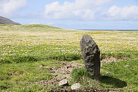 Standing stone on Barra
 -
 The 'lazy beds' of Harris
 -
 Lakes of North Uist
 -
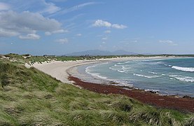 Beach on Benbecula
 -
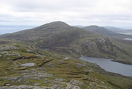 Mountains on South Uist
 -
 Eilean na Cille (at right), Triallabreac and Wiay from the air


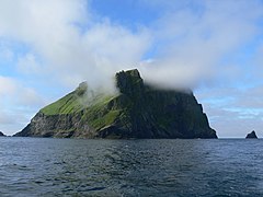
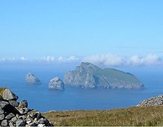
St Kilda and Rockall
-
 Soay
Soay -
 Rockall
 -
 Boreray with Stac an Armin (left) and Stac Lee (right)


Coat of arms

Inverness-shire's coat of arms is blazoned:
- Azure, in dexter chief a stag's head and in sinister chief a bull's head both erased, and in base a galley, sails furled, oars in action and flagged, all Or. Beneath the shield an escrol bearing this motto: Air son Math na Siorrachd.
The galley represents Clan Chattan, who aligned themselves under the banner of Somerled, Lord of the Isles. The stag's head comes from the crest of the Frasers of Lovat, while the bull's head comes from the crest of the MacLeods of that Ilk. The motto is in Gaelic and means "For the Good of the County".
Local government
1890–1975
Inverness-shire acquired a county council in 1890, under the Local Government (Scotland) Act 1889, and, under the same legislation, boundaries were altered to make the county a single contiguous area, transferring several exclaves of other counties to Inverness-shire.
Although the new boundaries were supposed to be valid for all purposes (unlike earlier boundaries, which were really default boundaries and not necessarily those used for any particular purpose), the burghs of Inverness, Fort William, Kingussie, which had their own town councils, retained autonomous status and were for some purposes beyond the writ of the new county council. The town of Inverness had been established as a royal burgh since the mid 12th century, Fort William, originally a Fort of that name built by the Government to keep the Highlanders in their place, around which grew up a village which became in turn Gordonsburgh, Maryburgh, Duncansburgh and latterly the town/burgh of Fort William which had been established as a burgh of barony since 1618 and Kingussie had been established as a burgh of barony since 1464. Also, use of the new boundaries for parliamentary elections was specifically excluded.
1975–1996
The old county councils were abolished by the Local Government (Scotland) Act 1973 and Scotland was instead governed by a two-tier system of regions and districts. Mainland Inverness-shire was split amongst four districts of the Highland region, whilst the county's territory in the Outer Hebrides was transferred to the Western Isles council area.
- 1. The burgh of Inverness and the Aird and Inverness districts were merged to form the Inverness Local Government district of the Highland region.
- 2. The burgh of Fort William and the Lochaber district were merged with areas from the county of Argyll (the Ardnamurchan district and the electoral divisions of Ballachulish and Kinlochleven) to form the Lochaber district of the Highland region.
- 3. The Skye district was merged with an area from the county of Ross and Cromarty (the South West district) to form the Skye and Lochalsh district of the Highland region.
- 4. The burgh of Kingussie and the Badenoch district were merged with areas from the county of Moray (the burgh of Grantown-on-Spey and the Cromdale district) to form the Badenoch and Strathspey district of the Highland region.
- The Barra, Harris, North Uist, and South Uist districts were merged with areas from the county of Ross and Cromarty (the burgh of Stornoway and Lewis district) to form the Western Isles council area.
Within the Highland region, local government functions were divided between the regional council and the district councils. For example, education was a regional responsibility, and housing was a district responsibility.
1996–present
In 1996, under the Local Government etc (Scotland) Act 1994, the two-tier system was abolished and the Highland region became a unitary council area.
The new unitary Highland Council adopted the areas of the former districts as management areas. Each management area was represented, initially, by area committees consisting of councillors elected from areas (groups of local government wards) corresponding to the management areas, but changes to ward boundaries in 1999 created a mismatch between committee areas and management areas.
In 2007, at the time of further changes to ward boundaries, which created 22 multi-member wards instead of 80 single-member wards, the council created a new management structure, with three new corporate management areas and 16 new ward-level management areas. Also, four of the ward-level management areas, covering the seven wards, were grouped to form an Inverness city (or Inverness and Area) management area.
The total number of Highland councillors is 80, elected by the single transferable vote system of election, which is designed to produce a form of proportional representation. Wards in the Inverness city area elect 26 of the 34 council members elected from the Inverness, Nairn and Badenoch and Strathspey corporate management area.
The city area has the Nairn ward-level management area to the east, the Badenoch and Strathspey ward-level management area to the east and south, the Ross, Skye and Lochaber corporate management area to the south, west and north, and the Moray Firth to the north.
The city area is similar but not identical to the former district of Inverness.
| Ward[2] | Description | Seats | Ward-level management area |
|---|---|---|---|
| Aird and Loch Ness | Includes Loch Ness, the town of Beauly, and the village of Fort Augustus Aird is a former district of the county of Inverness |
4 | City area 1, covering the Aird and Loch Ness ward and a southern portion of the Inverness South ward |
| Culloden and Ardersier | Includes the villages of Culloden, Ardersier and Smithton | 4 | City area 4, covering the Culloden and Ardersier ward and a northern portion of the Inverness South ward |
| Inverness Central | Includes Dalneigh, Glebe, Haugh, Merkinch and South Kessock areas of urban Inverness | 4 | City area 3, covering the two wards of Inverness Central and Inverness Millburn |
| Inverness Millburn | Includes Millburn, Culcabock, Longman and Raigmore areas of urban Inverness | 3 | City area 3, covering the two wards of Inverness Central and Inverness Millburn |
| Inverness Ness-side | Includes Drummond, Hilton and Lochardil areas of Inverness, and a more rural area, east of the River Ness | 4 | City area 2, covering the two wards of Inverness Ness-side and Inverness West |
| Inverness South | Includes Cradlehall, Inshes and Westhill areas in or near urban Inverness, and the village of Tomatin, on the River Findhorn | 4 | Divided between city area 1, covering the Aird and Loch Ness ward and a southern portion of the Inverness South ward, and city area 4, covering the Culloden and Ardersier ward and a northern portion of the Inverness South ward |
| Inverness West | Includes Kinmylies and Scorguie areas of urban Inverness, and a more rural area, west of the River Ness | 3 | City area 2, covering the two wards of Inverness Ness-side and Inverness West |
Civil parishes

Civil parishes are still used for some statistical purposes, and separate census figures are published for them. As their areas have been largely unchanged since the 19th century this allows for comparison of population figures over an extended period of time.
In 1854 in Inverness-shire there were 29 civil parishes; 7 part civil parishes; and 5 parliamentary parishes.[3]
- Abernethy and Kincardine
- Alvie
- Ardersier
- Arisaig and Moidart
- Barra
- Boleskine and Abertarff
- Bracadale
- Cawdor part (now in Nairnshire)
- Cromdale Inverallan and Advie
- Croy, Highland and Dalcross, Highland
- Daviot
- Dunlichity
- Dores
- Duirinish
- Duthil and Rothiemurchus
- Glenelg
- Harris
- Inverness and Bona[4]
- Kilmallie
- Kilmonivaig
- Kilmorack
- Kilmuir
- Kiltarlity and Convinth
- Kingussie and Insh
- Kirkhill
- Laggan or Kinloch Laggan
- Moy and Dalarossie
- North Uist
- Petty
- Portree
- Sleat
- Small Isles
- Snizort
- South Uist
- Strath
- Urquhart and Glenmoriston
- Urray
Transport

.jpg)
The Highland Main Line connects Inverness by rail to Perth to the south, Kyle of Lochalsh to the west and Thurso/Wick to the north. The West Highland Line connects Fort William to Mallaig. The Inverness to Aberdeen main line also serves Nairn within the Highland Council's area.
The Isle of Skye is connected to the mainland by a bridge from Kyle of Lochalsh in Ross-shire.
Various bus companies serve the larger towns of the county, such as Stagecoach Group and Scottish Citylink. PlusBus operate local services in the Inverness area, and Shiel Buses in the Fort William area. Stagecoach operate several bus routes on the Isle of Skye.[5]
Numerous ferries connect the islands of the Outer Hebrides to each and also the Inner Hebrides and the Scottish mainland.
There are three airports in the county: Inverness, Benbecula and Barra. All three operate flights within Scotland, with Inverness also providing flights to other cities in the UK as well as some destinations in Europe. Barra Airport is famous within aviation circles as it is the only airport in the world where scheduled flights use a beach as the runway.[6]
Settlements
Mainland
- Abriachan
- The Aird
- Altrua
- Ardersier
- Arisaig
- Aviemore
- Ballifeary
- Balloch
- Balnafettack
- Beauly
- Boat of Garten
- Bught
- Bunree
- Cannich
- Carrbridge
- Clachnaharry
- Cradlehall
- Crown
- Croy
- Culcabock
- Culduthel
- Culloden
- Dalneigh
- Dalwhinnie
- Dores
- Drakies
- Drumnadrochit
- Dulnain Bridge
- Fort Augustus
- Fort William
- Foyers
- Glenelg
- Glenfinnan
- Haugh
- Highbridge
- Hilton
- Holm
- Inchmore
- Insh
- Inshes
- Inverfarigaig
- Invergarry
- Inverie
- Inverlochy
- Invermoriston
- Kiltarlity
- Kilvean
- Kincraig
- Kingussie
- Kinlochmore
- Kinmylies
- Kirkhill
- Laggan, Badenoch
- Laggan, Great Glen
- Leachkin
- Lochailort
- Lochardil
- Longman
- Mallaig
- Merkinch
- Millburn
- Milton of Leys
- Morar
- Moy
- Muir of Ord (shared with Ross-shire)
- Muirtown
- Nethy Bridge
- Newtonmore
- North Ballachulish
- Onich
- Raigmore
- Roybridge
- Scorguie
- Smithton
- South Kessock
- Spean Bridge
- Struy
- Tomatin
- Tomich
- Upper Achintore
- Westhill
Islands
- Achachork (Skye)
- Aird of Sleat (Skye)
- Allasdale (Barra)
- Amhuinnsuidhe (Harris)
- Ardhasaig (Harris)
- Ardheisker (North Uist)
- Ardmore (Barra)
- Ardvasar (Skye)
- Ardveenish (Barra)
- Armadale (Skye)
- Ashaig (Skye)
- Askernish (South Uist)
- Auratote (South Uist)
- Bail' Iochdrach (Benbecula)
- Baile Glas (Grimsay)
- Balgarva (South Uist)
- Balivanich (Benbecula)
- Bernisdale (Skye)
- Bogach (Barra)
- Bornesketaig(Skye)
- Boreraig (Skye)
- Bornish (South Uist)
- Borreraig (Skye)
- Borrodale (Skye)
- Borsham (Harris)
- Borve (Barra)
- Borve (Harris)
- Borve (Skye)
- Bracadale (Skye)
- Brevig (Barra)
- Broadford (Skye)
- Brogaig (Skye)
- Bualintur (Skye)
- Camastianavaig (Skye)
- Camuscross (Skye)
- Caolas (Vatersay)
- Carbost, Loch Harport (Skye)
- Carbost, Trotternish (Skye)
- Carinish (North Uist)
- Castlebay (Barra)
- Claigan (Skye)
- Cleadale (Eigg)
- Colbost (Skye)
- Daliburgh (South Uist)
- Drumfearn (Skye)
- Drynoch (Skye)
- Dunan (Skye)
- Duntulm (Skye)
- Dunvegan (Skye)
- Eabost (Skye)
- Edinbane (Skye)
- Elgol (Skye)
- Ellishadder (Skye)
- Eynort (Skye)
- Eyre (Skye)
- Fasach (Skye)
- Feorlig (Skye)
- Ferindonald (Skye)
- Fiskavaig (Skye)
- Flashader (Skye)
- Flodigarry (Skye)
- Galmisdale (Eigg)
- Galtrigill (Skye)
- Garafad (Skye)
- Geary (Skye)
- Gedintailor (Skye)
- Gillen (Skye)
- Glendale (Skye)
- Halistra (Skye)
- Harlosh (Skye)
- Heaste (Skye)
- Howmore (South Uist)
- Hushinish (Harris)
- Inverarish (Raasay)
- Iochdar (South Uist)
- Isleornsay (Skye)
- Kensaleyre (Skye)
- Kilaulay (South Uist)
- Kilbride (Skye)
- Kilmaluag (Skye)
- Kilmarie (Skye)
- Kilmore (Skye)
- Kilmuir (Skye)
- Kilvaxter (Skye)
- Kingsburgh (Skye)
- Kyleakin (Skye)
- Kylerhea (Skye)
- Lealt (Skye)
- Leverburgh (Harris)
- Lochboisdale (South Uist)
- Lochmaddy (North Uist)
- Lower Breakish (Skye)
- Luib (Skye)
- Luskentyre (Harris)
- Milovaig (Skye)
- Mugeary (Skye)
- Newtonferry (North Uist)
- Northbay (Barra)
- Nunton (Benbecula)
- Ollach (Skye)
- Ose (Skye)
- Peinachorran (Skye)
- Portnalong (Skye)
- Portree (Skye)
- Ramasaig (Skye)
- Rèinigeadal (Harris)
- Roag (Skye)
- Rodel (Harris)
- Sconser (Skye)
- Skeabost (Skye)
- Sligachan (Skye)
- Staffin (Skye)
- Stoneybridge (South Uist)
- Stein (Skye)
- Sollas (North Uist)
- Struan (Skye)
- Suladale (Skye)
- Talisker (Skye)
- Tarbert (Harris)
- Tarskavaig (Skye)
- Teangue (Skye)
- Tigharry (North Uist)
- Torrin (Skye)
- Totaig (Skye)
- Tote (Skye)
- Treaslane (Skye)
- Trumpan (Skye)
- Uachdar (Benbecula)
- Uig (Skye)
- Uigshader (Skye)
- Ullinish (Skye)
- Upper Breakish (Skye)
- Vatten (Skye)
Parliamentary constituencies
There was an Inverness-shire constituency of the Parliament of Great Britain (Westminster) from 1708 to 1801 and of the Parliament of the United Kingdom (also at Westminster) from 1801 to 1918. The constituency represented, nominally, the county of Inverness minus the parliamentary burgh of Inverness, which was represented as a component of the Inverness District of Burghs constituency.
In 1918 the county constituency was divided between two new constituencies, the Inverness constituency and the Western Isles constituency. The Inverness constituency included the burgh of Inverness, other components of the district of burghs being divided between the Moray and Nairn constituency and the Ross and Cromarty constituency.
In 1983, eight years after the local government county of Inverness had been divided between the Highland region and the Western Isles council area, three new constituencies were created to cover the Highland region. The region, until 1996, and the unitary Highland council area, 1996 to present, have been covered by three constituencies since then but there were changes to boundaries and names in 1997 and 2005.
In 1999 the areas of the Westminster constituencies became also constituencies of the Scottish Parliament (Holyrood). The boundaries of Scottish Parliament constituencies have not altered since then. The Holyrood constituencies are within the Highlands and Islands electoral region.
Since 1983, Inverness has appeared in the names of Westminster and Holyrood constituencies as tabled below.
Westminster constituencies
| Period | Constituency or constituencies |
|---|---|
| 1983 to 1997 | Inverness, Nairn and Lochaber |
| 1997 to 2005 | Ross, Skye and Inverness West |
| Inverness East, Nairn and Lochaber | |
| 2005 to present | Inverness, Nairn, Badenoch and Strathspey |
Holyrood constituencies
| Period | Constituencies |
|---|---|
| 1999 to present | Ross, Skye and Inverness West |
| Inverness East, Nairn and Lochaber |
See also
Notes and references
- ^ "The Area of Invernesshire". British Towns and Villages Network. 28 September 2014. Retrieved 29 December 2014.
- ^ "Your Ward". Highland Council website. Retrieved 8 April 2008.
- ^ Revd John Marius Wilson, ed. (1854). The Imperial gazetteer of Scotland. Vol. 2 (Gordon – Zetland). Edinburgh: A. Fullarton. p. 137. OL 14014352M.
- ^ http://www.ambaile.org.uk/en/item/item_photograph.jsp?item_id=2580 Archived 20 January 2013 at the Wayback Machine
- ^ "Stagecoach North Scotland - Isle of Skye" (PDF). Retrieved 23 June 2019.
- ^ "Barra Airport". Highlands and Islands Airports Limited. Archived from the original on 22 March 2009. Retrieved 6 April 2009.
Local government areas of Scotland, in use 1975 to 1996 | ||
|---|---|---|
| Borders |  | |
| Central Region | ||
| Dumfries and Galloway | ||
| Fife | ||
| Grampian | ||
| Highland | ||
| Lothian | ||
| Strathclyde | ||
| Tayside | ||
| Island areas1 | ||