Valapattanam River
Appearance
| Valapattanam വളപട്ടണം നദി | |
|---|---|
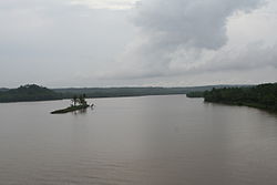
 A view of Valapattanam river from Parassinikkadavu Bridge. | |
 | |
| Location | |
| Country | India |
| State | Kerala |
| District | Kannur |
| Physical characteristics | |
| Mouth | |
• location | Arabian Sea (Azhikkal, India were Azhikkal port is situated) |
• elevation | 0 m (0 ft) |
| Length | 110 km (68 mi) |
| Basin features | |
| Progression | West flowing river |
| Landmarks | Muthappan temple |
The Valapattanam River is the largest river in the Kannur district, located in the South Indian state of Kerala.
The Valapattanam River originates from the Brahmagiri hills in Bramhagiri Reserve Forest in Karnataka at an altitude of 900-1350m above sea level and drains into the Kannur district. Towns like Iritty, Irikkur, Parassinikkadavu, Valapattanam and Pappinisseri are on its banks. The Parassinikkadavu temple is also on the bank of this river.
Tributaries
- Sreekandapuram river
- Aralam river
- Irikkur river
- Bavali river
Wikimedia Commons has media related to Valapattanam River.
11°56′N 75°18′E / 11.933°N 75.300°E
