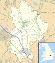
Bedford Aerodrome
Appearance
Bedford Aerodrome | |||||||||||
|---|---|---|---|---|---|---|---|---|---|---|---|
| Summary | |||||||||||
| Airport type | Private | ||||||||||
| Operator | MotorSport Vision Ltd. | ||||||||||
| Serves | Bedford Autodrome | ||||||||||
| Location | Thurleigh | ||||||||||
| Elevation AMSL | 273 ft / 83 m | ||||||||||
| Coordinates | 52°13′57″N 000°26′44″W / 52.23250°N 0.44556°W | ||||||||||
| Website | www.bedfordaerodrome.com | ||||||||||
| Map | |||||||||||
 | |||||||||||
| Runways | |||||||||||
| |||||||||||
Bedford Aerodrome (ICAO: EGBF) is located 5 nautical miles (9.3 km; 5.8 mi) north of Bedford, in Bedfordshire, England. The aerodrome which is privately owned serves the Bedford Autodrome.
References
- ^ EGBF - Bedford Aerodrome, Civil Aviation Authority, 25 May 2014

