
Berg en Dal (municipality)
Berg en Dal | |
|---|---|
 Flag Coat of arms | |
.svg) Location in Gelderland | |
| Coordinates: 51°47′N 5°56′E / 51.783°N 5.933°E | |
| Country | Netherlands |
| Province | Gelderland |
| Established | 2015 (renamed in 2016) |
| Government | |
| • Body | Municipal council |
| • Mayor | Mark Slinkman (CDA) |
| Area | |
| • Total | 93.28 km2 (36.02 sq mi) |
| • Land | 86.31 km2 (33.32 sq mi) |
| • Water | 6.97 km2 (2.69 sq mi) |
| Elevation | 34 m (112 ft) |
| Population (January 2021)[4] | |
| • Total | 35,010 |
| • Density | 406/km2 (1,050/sq mi) |
| Time zone | UTC+1 (CET) |
| • Summer (DST) | UTC+2 (CEST) |
| Postcode | 6560–6564, 6570–6572 |
| Area code | 024 |
| Website | www |

Berg en Dal (literally in English: Mountain and Valley) is a municipality in the eastern Netherlands, in the province of Gelderland. It was formed through a merger of the municipalities of Groesbeek, Millingen aan de Rijn and Ubbergen in 2015. The resulting larger municipality maintained the name of Groesbeek until 2016, when it was renamed to Berg en Dal after the village of Berg en Dal.[5]
Berg en Dal has about 34,714 inhabitants and covers an area of about 93 km². The municipality borders in the north on the Waal river and the Bijlands Kanaal, in the east on the German forest of the Reichswald, in the south on the province of Limburg, in the southwest on the forest of the Mookerheide (also Limburg), and in the west on the city of Nijmegen.
Berg en Dal is slightly hilly with altitudes reaching the 75 meters, like the Duivelsberg.
The International Four Days Marches Nijmegen crosses the municipality on the 3rd day (Day of Groesbeek).
Population centres
- Beek
- Berg en Dal (village)
- Breedeweg
- Colonjes
- De Horst
- De Kamp
- De Vlietberg
- Erlecom
- Grafwegen [6]
- Groenlanden
- Groesbeek
- Haukes
- Heikant [7]
- Heilig Landstichting [8]
- Holdeurn
- Kekerdom
- Leuth
- Meerwijk
- Millingen aan de Rijn
- Ooij
- Persingen
- Plak
- Tiengeboden
- Ubbergen
- Valkenlaagte
- Wercheren
- Wyler [6]
- Zeeland
Politics
The municipal council exists of 23 members, which are divided as follows:
- CDA, 3 seats
- Groesbeekse Volkspartij (GVP), 3 seats
- Voor Openheid en een Leefbaar Groesbeek (VOLG), 3 seats
- Combinatie'90 (C'90), 2 seats
- Gemeente-, Jeugd- en Sportbelangen (GJS), 2 seats
- GroenLinks, 2 seats
- PvdA, 2 seats
- Sociaal Groesbeek, 2 seats
- Voor Berg en Dal (VBenD), 2 seats
- D66 Berg en Dal, 1 seat
- VVD, 1 seat
CDA, Groesbeekse Volkspartij (GVP), Voor Openheid en een Leefbaar Groesbeek (VOLG), Combinatie'90 (C'90), Gemeente-, Jeugd- en Sportbelangen (GJS), and Voor Berg en Dal (VBenD) have formed a coalition.
The municipal executive consists of mayor Mark Slinkman (CDA) and four aldermen (1 CDA, 1 GVP, 1 C'90, 1 VOLG).
Notable people
.jpg)

- Anthony Van Egmond (1778 in Groesbeek – 1838) a Dutch Napoleonic War veteran and settler in southwestern Ontario
- Sebastiaan Tromp (1889 in Beek – 1975) a Dutch Jesuit priest, theologian and Latinist
- Dries van Agt (born 1931 in Geldrop) a retired Dutch politician, Prime Minister of the Netherlands 1977 to 1982
- Baron Berend-Jan van Voorst tot Voorst (born 1944 in Beek) a retired Dutch politician, diplomat and jurist
- Constantijn Kortmann (1944 in Groesbeek – 2016) a Dutch professor of constitutional law
- Marie-Claire "Amber" Cremers (born 1969 in Ubbergen) a Dutch-born German singer/songwriter
- Sharon Gesthuizen (born 1976) a Dutch politician and trade unionist, grew up in Millingen aan de Rijn
- Bas Eickhout (born 1976 in Groesbeek) a Dutch politician and Member of the European Parliament
Sport
- Peter Arntz (born 1953 in Leuth) a Dutch retired football midfielder with 411 club caps
- Jan Peters (born 1954 in Groesbeek) a retired footballer with 380 club caps
- Reza Hormes-Ravenstijn (born 1967 in Beek) a Dutch cyclo-cross racer
- Yelmer Buurman (born 1987 in Ubbergen) a Dutch professional racing driver
- Jasper Cillessen (born 1989) a Dutch professional football goalkeeper, 52 caps for the Netherlands national football team, grew up in Groesbeek
Gallery
-
 Knapheideweg, Groesbeek
 -
 Zuidmolen Groesbeek
 -
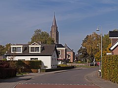 Millingen ad Rijn, toren van de Sint-Antonius van Paduakerk
 -
 Heuvellust Rijksstraatweg, Ubbergen


References
- ^ "Samenstelling college" [Members of the board] (in Dutch). Gemeente Berg en Dal. Retrieved 4 July 2014.[permanent dead link]
- ^ "Kerncijfers wijken en buurten 2020" [Key figures for neighbourhoods 2020]. StatLine (in Dutch). CBS. 24 July 2020. Retrieved 19 September 2020.
- ^ "Postcodetool for 6562AH". Actueel Hoogtebestand Nederland (in Dutch). Het Waterschapshuis. Retrieved 4 July 2014.
- ^ "Bevolkingsontwikkeling; regio per maand" [Population growth; regions per month]. CBS Statline (in Dutch). CBS. 1 January 2021. Retrieved 2 January 2022.
- ^ "Naam Berg en Dal toch op kombord Groesbeek". de Gelderlander. 24 October 2015. Archived from the original on 2015-10-25. Retrieved 8 January 2016.
- ^ a b Mainly in German Kranenburg municipality.
- ^ Former hamlet.
- ^ De facto a neighbourhood of Nijmegen.
External links
- (in Dutch) Official website Berg en Dal
Places adjacent to Berg en Dal (municipality) | ||||||||||||||||
|---|---|---|---|---|---|---|---|---|---|---|---|---|---|---|---|---|
| ||||||||||||||||

| Authority control databases: Geographic |
|---|
This Gelderland location article is a stub. You can help Wikipedia by expanding it. |