Urad Front Banner
Urad Front Banner
乌拉特前旗 · ᠤᠷᠠᠳ ᠤᠨ ᠡᠮᠦᠨᠡᠳᠦ ᠬᠣᠰᠢᠭᠤ | |
|---|---|
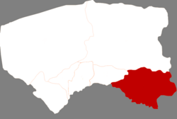
 Urat Front Banner in Bayannur | |
 Bayannur in Inner Mongolia | |
| Coordinates: 40°44′13″N 108°39′07″E / 40.737°N 108.652°E | |
| Country | People's Republic of China |
| Province | Inner Mongolia |
| Prefecture-level city | Bayannur |
| Time zone | UTC+8 (China Standard) |
Urad Front Banner (Mongolian: ᠤᠷᠠᠳ ᠤᠨ ᠡᠮᠦᠨᠡᠳᠦ ᠬᠣᠰᠢᠭᠤ Урадын Өмнөд Хошуу Urad-un Emünedü Qosiɣu; simplified Chinese: 乌拉特前旗; traditional Chinese: 烏拉特前旗; pinyin: Wūlātè Qián Qí) is a banner of the Inner Mongolia Autonomous Region, People's Republic of China. It is located in the west of the region, situated on the northern (left) bank of the Yellow River, on the Ordos Loop, and in between the cities of Bayan Nur and Baotou. Administratively, it is part of Bayan Nur City, and has a total area of 7,476 square kilometres (2,886 sq mi) and in 2004 had 340,000 inhabitants. Its seat is the town of Mona-uul (乌拉山镇). Other towns include Dashetai (Tashetai) (大佘太镇).[1]

References
