
Bamburgh
| Bamburgh | |
|---|---|
 Bamburgh in 1973 | |
 Bamburgh Location within Northumberland | |
| Population | 414 (2011) |
| OS grid reference | NU1734 |
| Civil parish |
|
| Unitary authority | |
| Ceremonial county | |
| Region | |
| Country | England |
| Sovereign state | United Kingdom |
| Post town | BAMBURGH |
| Postcode district | NE69 |
| Dialling code | 01668 |
| Police | Northumbria |
| Fire | Northumberland |
| Ambulance | North East |
| UK Parliament | |
Bamburgh (/ˈbæmbərə/ BAM-bər-ə) is a village and civil parish on the coast of Northumberland, England. It had a population of 454,[1] decreasing to 414 at the 2011 census.[2]
The village is notable for the nearby Bamburgh Castle, a castle which was the seat of the former Kings of Northumbria, and for its association with the Victorian era heroine Grace Darling, who is buried there.
The extensive beach by the village was awarded the Blue Flag rural beach award in 2005. The Bamburgh Dunes, a Site of Special Scientific Interest, stand behind the beach. Bamburgh is popular with holidaymakers and is within the Northumberland Coast Area of Outstanding Natural Beauty.
History
The site now occupied by Bamburgh Castle was previously home to a fort of the indigenous Celtic Britons known as Din Guarie[3] and may have been the capital of the kingdom of Bernicia, the realm of the Gododdin people,[4] from the realm's foundation in c. 420 until 547, the year of the first written reference to the castle. In that year the citadel was captured by the Anglo-Saxon ruler Ida of Bernicia (Beornice) and became Ida's seat.[5]
Late medieval British author Thomas Malory identified Bamburgh Castle with Joyous Gard, the mythical castle home of Sir Launcelot in Arthurian legend.[6]
St Aidan's Church

According to Bede, St Aidan built a wooden church outside the castle wall in AD 635, and he died here in AD 652. A wooden beam preserved inside the church is traditionally said to be the one on which he rested as he died.[7] The present church dates from the late 12th century, though some pre-conquest stonework survives in the north aisle. The chancel, said to be the second longest in the country (60 ft; 18m), was added in 1230; it contains an 1895 reredos in Caen stone by W.S. Hicks, depicting northern saints of the 7th and 8th centuries. There is an effigy of local heroine Grace Darling in the North Aisle. Her memorial is sited in the churchyard in such a position that it can be seen by passing ships.[8]
Governance
An electoral ward of the same name exists. This ward includes Belford and also stretches south to Ellingham with a total population taken at the 2011 census of 4,846.[9]
Notable people
- Æthelfrith of Northumbria
- William George Armstrong
- Joe Baker-Cresswell
- Ida of Bernicia
- Prideaux John Selby
- Grace Darling
Photo gallery
-
 Bamburgh village and surroundings
 -
 Bamburgh seen from the castle
 -
 Grace Darling memorial in the churchyard
 -
 The Grace Darling Museum, opposite the church
 -
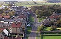
 Crossroads in the village, looking towards the castle
 -
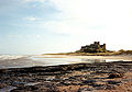 Beach and castle, looking south
 -
 A map of Bamburgh from 1947


Bamburgh Lighthouse
 Bamburgh Lighthouse | |
 | |
| Location | Bamburgh, Northumberland, England |
|---|---|
| OS grid | NU1734 |
| Coordinates | 55°36′59.6″N 1°43′27″W / 55.616556°N 1.72417°W |
| Constructed | 1910 |
| Construction | masonry building |
| Automated | 1910 |
| Height | 9 m (30 ft) |
| Shape | parallelepiped building with lantern on the roof |
| Markings | white building, black lantern |
| Operator | Trinity House[10] |
| Light | |
| Focal height | 12.5 m (41 ft) |
| Intensity | 7,140 candela |
| Range | white: 14 nmi (26 km) red and green: 11 nmi (20 km) |
| Characteristic | Oc (2) WRG 8s. |
Bamburgh Lighthouse was built by Trinity House in 1910 to guide shipping both passing along the Northumberland coast and in the waters around the Farne Islands. It was extensively modernised in 1975 and is now monitored from the Trinity House Operations and Planning Centre in Harwich. Routine maintenance is carried out by a local attendant. It is the most northerly land-based lighthouse in England.[11]
When originally built, the lamp was mounted on a skeletal steel tower (the footprint of which can still be seen within the compound) which stood alongside the white building which housed an acetylene plant to power the lamp.[12] (A similar arrangement can be seen today at Peninnis Lighthouse.) During electrification in 1975 the tower was removed, and the lantern was placed instead on top of the (now redundant) acetylene building.[11]
See also
- Bamburgh Coast and Hills, a Site of Special Scientific Interest along the coast north-east of Bamburgh
- List of lighthouses in England
References
- ^ Neighbourhood Statistics. "Census 2001". Neighbourhood.statistics.gov.uk. Retrieved 2 August 2012.
- ^ "Parish population 2011". Retrieved 25 June 2015.
- ^ "Bernaccia (Bryneich / Berneich)". The History Files. Retrieved 18 June 2018.
- ^ 'An English empire: Bede and the early Anglo-Saxon kings' by N. J. Higham, Manchester University Press ND, 1995, ISBN 0-7190-4423-5, ISBN 978-0-7190-4423-6
- ^ The Anglo-Saxon Chronicle, entry for 547.
- ^ Black, Joseph (2016). "The Broadview Anthology of British Literature: Concise Volume A - Third Edition". Broadview. p. 536. ISBN 978-1554813124.
- ^ "St Aidan, Bamburgh". Retrieved 19 June 2018.
- ^ Purves, Churches of Newcastle and Northumberland, Tempus, Stroud, 2006
- ^ "Parish Population 2011". Retrieved 25 June 2015.
- ^ Bamburgh The Lighthouse Directory. University of North Carolina at Chapel Hill. Retrieved April 29, 2016
- ^ a b "Bamburgh Lighthouse". Trinity House.
{{cite web}}: Cite has empty unknown parameter:|coauthors=(help) - ^ Vintage postcard showing original arrangement.
- Chisholm, Hugh, ed. (1911). . Encyclopædia Britannica (11th ed.). Cambridge University Press.
External links
- Bamburgh Photos
- Local History and Information on Bamburgh, The Farne Islands and surrounding areas.
- Stained glass windows at St. Aidan's Church, Photos by Peter Loud
- Bamburgh Tourist Attractions
- Bamburgh Online
- GENUKI (Accessed: 5 November 2008)
- Northumberland Communities (Accessed: 5 November 2008)
- Trinity House