Chaliyar
| Chaliyar ചാലിയാർ | |
|---|---|
 | |
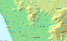
 Labelled map of Chaliyar | |
| Location | |
| Country | India |
| State | Kerala, Tamil Nadu |
| District | Wayanad, Malappuram, Kozhikode |
| City | Pothukal, Chungathara, Nilambur, Mampad, Edavanna, Kavanoor, Perakamanna, Areekode, Kizhuparamba, Elamaram, cheekode, Vazhakkad, Vazhayur, Cheruvadi, Mavoor, Peruvayal, Perumanna, Aakode, Feroke, Chaliyam. |
| Physical characteristics | |
| Source | Elambaleri Hills |
| • location | Western Ghats, Wayanad, India |
| Mouth | Lakshadweep Sea[1] |
• location | Chaliyam, Kerala, India |
• coordinates | 11°10′N 75°48′E / 11.16°N 75.80°E |
• elevation | 0 m (0 ft) |
| Length | 169 km (105 mi)[1] |
| Basin size | 2,933 km2 (1,132 sq mi) |
| Discharge | |
| • location | mouth |
| Basin features | |
| Tributaries | |
| • left | Iruvazhinjipuzha, Cherupuzha, Engappuzha |
| • right | Cherupuzha Nilambur |
Chaliyar River is the fourth longest river in Kerala at 169 km in length. The Chaliyar is also known as Chulika River, Nilambur River or Beypore River as it is near the sea. Pothukal, Chungathara, Nilambur, Mampad, Edavanna, Kavanoor, Perakamanna, Areekode, Kizhuparamba, Elamaram, Cheekkode, Vazhakkad, Vazhayur, Cheruvadi, Edavannappara, Mavoor, Peruvayal, Perumanna, Feroke and Beypore are some of the towns/villages situated along the banks of the Chaliyar. It mainly flows through Malappuram district. Its tributaries flow through both the districts of Malappuram and Kozhikode. The bank of river Chaliyar in the Nilambur region is also known for its natural Gold fields.[2] Explorations done at the valley of the river Chaliyar in Nilambur have shown reserves of the order of 2.5 million cubic meters of placers with 0.1 gram per cubic meter of gold.[3] It originates at the Ilambaleri hills of Nilgiri Mountains in Nilgiris district (Ooty district), which is also near Wayanad-Malappuram district border. It flows mainly through the erstwhile region of Eranad (present-day Malappuram district), and finally empties into the Arabian Sea at Beypore port, opposite to Chaliyam harbour.
Name
[edit]
The river has three names - Chaliyar, Nilambur River, and Beypore puzha, of which the first one is more popular. The river meets the Lakshadweep Sea[1] at an 'azhi' (estuary), the southern part of which is known as Chaliyam and northern part as Beypore. Unlike many other rivers in Kerala, Chaliyar does not dry up during the dry season in December and March.
Chaliyar is also the name of a place and a Grama panchayat in Nilambur Taluk, which is located near the Nilambur Municipality, where Conolly's plot, the oldest manmade teak plantation in the world is located.[4]
Course
[edit]
The Chaliyar originates in the Western Ghats range at Ilambaleri hills in the ranges of Nilgiri Mountains of Western Ghats,[5] which is also near Wayanad-Malappuram district border. Chaliyar flows through Malappuram District for most of its length and then for around 17 km it forms the boundary between Malappuram District and Kozhikode District before entering the city of Kozhikode for its final 10 km journey and finally empties into the Lakshadweep Sea at Beypore. Six major streams Chaliyarpuzha, Punnapuzha, Kanjirapuzha, Karimpuzha, Iruvahnipuzha and Thottumukkampuzha constitute the Chaliyar River drainage system. Other important tributaries are Kurumanpuzha, Pandipuzha, Maradipuzha, Kuthirapuzha and Karakkodupuzha. Most of these rivers have their origin in the Nilgiri hills in the east and Wayanad hills in the north, where they form a number of rapids and waterfalls.[5] Near the origin of river are the Meenmutty Falls at coordinates 11°31′40″N 76°14′12″E / 11.527755°N 76.236534°E by Vaduvanchal, Wayanad & Soochipara_Falls which situated in Chullikka River a part of Chaliyar River.
Economy
[edit]During late 19th century and early 20th century, the Chaliyar was extensively used as a waterway for carrying timber from the forest areas in and around Nilambur to the various mills in Kallai of Calicut city. Rafts made of logs were taken downstream during the monsoon season to Kallayi, where these were sawn to size in the timber mills dotting the banks of the river. Kallai was during this period one of the most important centers in the world for timber business. The place was famous for wood of superlative strength and durability like teak, rosewood, etc. Towards the second half of the 20th century, the activity came down drastically as tree felling was banned or strictly controlled with a view to stop deforestation. Many mills still operate in Kallai, though with far less output. Many have closed down.
Ecology
[edit]


Chaliyar River was in the news a few years ago because of the ecological damage caused by a pulp factory at Mavoor, that released effluents into the river and affected the marine life. This factory has since closed down.
K. A. Rahman led the agitation for cleanup of the river, and inspired the formation of an anti-pollution committee, Paristhithi Samrakshana Samithi, in 1999.[citation needed]
Tributaries
[edit]- Cherupuzha (Mavoor)
- Engappuzha
- Iruthullippuzha
- Kadungampuzha
- Iruvanjippuzha
- Pulingappuzha
- Chalippuzha. The Thusharagiri Falls are situated on this river.
- Muthappanpuzha
- Thottumukkampuzha
- Kuthirappuzha
- Kuruvanpuzha
- Kanjirappuzha
- Karimpuzha
- Pandippuzha
- Neerppuzha
- Vadapurampuzha
In addition to these rivers some creeks also join Chaliyar from Neelithode, Poonkudi, Vadasseri, Edavanna, Kunduthodu and Mampad.
Tourism
[edit]
The banks of the Chaliyar River offer a variety of tourist attractions, rich in natural beauty, historical significance, and cultural heritage.[citation needed]
Bridges
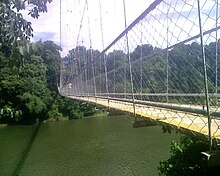
[edit]Bridges on this river include:[citation needed]
- Edavanna Bridge
- Areekkode Bridge
- Edasherikadavu Bridge
- Elamaram Bridge
- Oorkadavu Regulator cum Bridge
- Arappuzha Bridge (Part of NH 66 Bypass)
- Feroke New Bridge (Part of NH 66)
- Feroke Old Bridge
- Feroke Railway Bridge
Ghost town
[edit]Across the river Chaliyar lies the abandoned Grasim Industries factory which once employed 2,000 employees. Environmental agitations in 1998 caused the closure of the factory and the entire village went bankrupt because of the sudden development and eleven people even committed suicide because of not being able to face unexpected poverty.[citation needed]
Pilgrimage
[edit]The Konnara Dargah is three kilometres away from Elamaram on the bank of the Chaliyar river. It is the holy resting place of a Muslim saint where hundreds of pilgrims visit regularly.[citation needed]
Nearby villages
[edit]- Irumooliparamba, Ponnempadam, Channayil Palliyali (Santhigram), Akode, Virippadam, Korappadam, Mundumuzhi, Vazhakkad, Valillappuzha, Pancheeri, Elamaram, Mapram, Konnar, Vettathur, Cheruvadikavu, Neerad, Muthuvalloor, Moochikal, Mundakkulam, Muthuparamba, Vettukad, Omanoor, Ponnad, Iruppanthody Karatt Chola Kolambalam Edavannappara, Arappuzha, Cheruvannur.
See also
[edit]References
[edit]- ^ a b c "Evolution of Chaliyar River Drainage Basin Insights from Tectonic Geomorphology" (PDF). Cochin University of Science and Technology. p. 220. Retrieved 25 March 2014.
- ^ "Mineral Deposits in Kerala".
- ^ "Physical divisions of Malappuram" (PDF). censusindia.gov.in. pp. 21–22.
- ^ "Villages in Malappuram". lsgkerala.gov.in.
- ^ a b "Evolution of Chaliyar River Drainage Basin Insights from Tectonic Geomorphology" (PDF). Cochin University of Science and Technology. pp. 8–11. Retrieved 25 March 2014.
- "Infobox facts". All Kerala River Protection Council. Retrieved 27 August 2005.
- The River Chaliyar, by M. P. Chandran
- About the Rivers of Kerala
- K A Rahman[full citation needed]
