
Bomy
Bomy | |
|---|---|
 | |
Location of Bomy  | |
| Country | France |
| Region | Hauts-de-France |
| Department | Pas-de-Calais |
| Arrondissement | Saint-Omer |
| Canton | Fauquembergues |
| Intercommunality | Canton of Fauquembergues |
| Government | |
| • Mayor (2008–2014) | Alain Deblock |
| Area 1 | 14.63 km2 (5.65 sq mi) |
| Population (2009) | 596 |
| • Density | 41/km2 (110/sq mi) |
| Time zone | UTC+01:00 (CET) |
| • Summer (DST) | UTC+02:00 (CEST) |
| INSEE/Postal code | 62153 /62960 |
| Elevation | 85–180 m (279–591 ft) (avg. 102 m or 335 ft) |
| 1 French Land Register data, which excludes lakes, ponds, glaciers > 1 km2 (0.386 sq mi or 247 acres) and river estuaries. | |
Bomy is a commune in the Pas-de-Calais department in the Hauts-de-France region in northern France.
Its surrounded by the common Beaumetz-lès-Aire, Erny-Saint-Julien and Laires, Bomy is located 19 km southwest of Saint-Omer's largest city around.
Geography
A village situated 12 miles (19 km) south of Saint-Omer, on the D130 road.
Its surrounded by the common Beaumetz-lès-Aire, Erny-Saint-Julien and Laires, Bomy is located 19 km southwest of Saint-Omer, the largest city around.[1]
Population
| Year | Pop. | ±% |
|---|---|---|
| 1962 | 653 | — |
| 1968 | 674 | +3.2% |
| 1975 | 658 | −2.4% |
| 1982 | 603 | −8.4% |
| 1990 | 608 | +0.8% |
| 1999 | 604 | −0.7% |
| 2009 | 596 | −1.3% |
Sights
- The church of St. Vaast, dating from the thirteenth century.
- The remains of the old chateau, where a truce between France and Spain was signed in 1537.
- The present-day château. The building dates from 1755. It was confiscated during the French Revolution and sold for use as a sugar beet factory. It was sold again in 1839 to the Baron de Vilmarest.
-
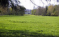
 The wooded site of the old château
 -
 The main façade of the present building
 -
 View of the rear of the château
 -
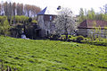 Weir on the river Locquette


See also
References
External links
Wikimedia Commons has media related to Bomy.
This Pas-de-Calais geographical article is a stub. You can help Wikipedia by expanding it. |