Coro Coro Municipality
Appearance
Coro Coro Municipality | |
|---|---|
Municipality | |
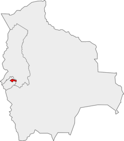
 Location of the Coro Coro Municipality within Bolivia | |
| Coordinates: 17°10′0″S 68°25′0″W / 17.16667°S 68.41667°W | |
| Country | |
| Department | La Paz Department |
| Province | Pacajes Province |
| Seat | Coro Coro |
| Government | |
| • Mayor | Simeon Paredes Salluco (2007) |
| • President | Brito Choque Mollo (2007) |
| Area | |
| • Total | 436 sq mi (1,128 km2) |
| Elevation | 13,000 ft (4,000 m) |
| Population (2001) | |
| • Total | 11,813 |
Coro Coro Municipality is the first municipal section of the Pacajes Province in the La Paz Department, Bolivia. Its seat is Coro Coro.

