
Doesburg
Doesburg | |
|---|---|
 Square in Doesburg | |
 Flag  Coat of arms | |
.svg) Location in Gelderland | |
| Coordinates: 52°1′N 6°8′E / 52.017°N 6.133°E | |
| Country | Netherlands |
| Province | Gelderland |
| Government | |
| • Body | Municipal council |
| • Mayor | Loes van der Meijs (PvdA) |
| Area | |
| • Total | 12.96 km2 (5.00 sq mi) |
| • Land | 11.53 km2 (4.45 sq mi) |
| • Water | 1.43 km2 (0.55 sq mi) |
| Elevation | 13 m (43 ft) |
| Population (January 2021)[4] | |
| • Total | 11,064 |
| • Density | 960/km2 (2,500/sq mi) |
| Demonym | Doesburger |
| Time zone | UTC+1 (CET) |
| • Summer (DST) | UTC+2 (CEST) |
| Postcode | 6980–6984 |
| Area code | 0313 |
| Website | www |
 Doesburg (Dutch pronunciation: [ˈduzbʏrx] ) is a municipality and a city in the eastern Netherlands in the province of Gelderland. Doesburg received city rights in 1237 and had a population of 11,064 in 2021. The city is situated on the right bank of river IJssel, at the confluence of river Oude IJssel. The municipality of Doesburg is part of the Arnhem-Nijmegen agglomeration region.
History
Doesburg received city rights in 1237, this was one year later than the neighbouring town of Doetinchem. Because of its strategic position along the Oude IJssel and Gelderse IJssel, Doesburg has been an important fortified city for a long time. The fortification of the city made Doesburg an important economic and administrative city. The Martinikerk, the main church in Doesburg is 94 meters tall. For many reasons, many of which have to do with the IJssel decreasing in depth, the prosperity in Doesburg settled after the 15th century. Doesburg changed into a sleepy provincial town and so it would remain until after the second world war. The city was protected in 1974, designated as a historic town.
As Doesburg was officially a fortified city up to 1923, town extension was not possible. After the second world war the city was rapidly extended. In the fifties on the Eastern side of the city the borough Molenveld (= mill field) was built. At south of the Oude IJssel followed in the seventies and eighties the borough Beinum. Recently at south of Beinum the borough Campstede has been built. At the beginning of the 21st century the construction of a new area at the IJsselkade was started with 44 houses and 124 apartments designed by the Italian architect Adolfo Natalini. In 2007, construction of a hotel was started called "Noabers". After a few months the hotel went bankrupt, but was taken over and reopened a year later.
Tourism
In the north of Doesburg there are several camp-sites where in the high season 4000 visitors stay each year. Also the historical inner city with several museums and many monuments draw thousands of tourists every year. Large tourist attractions are the Main court, the Doesburgse mustard factory and 'De Waag', which according to reports is the oldest public place in the Netherlands.
Industry
On the north side of the city, parallel to N317, lies the company area called Verheullweg. Here the international transport company Rotra and the construction material manufacturer Ubbink are established. To the east of the borough Beinum, along the provincial road N338, are the company areas Beinum-Oost and Beinum-West. Here various small and large ventures were established, among which are the manufacturer/wholesale company of gedistilleerd (Delcave), a houtverwerkende company (Aalbers), a plastic company (Dremefa) and a builder's company (Claus). Along the Gelderse Ijssel an iron foundry and a concrete call centre have been established, as well as, near the bridge, a builder of motor yachts.[citation needed]
Well-known Doesburgers
Doesburg's list of national characters and well known icons includes sea hero Jan van Kinsbergen, the family Verhuell to which the Verhuellweg has been named after.
Other well-known Doesburgers are chronicler Peter of Dusburg, politician Charles August Masse, politician Clemens Cornielje, son of the ex-mayor of the former municipality Angerlo, and current mayors Niels Joosten (municipality of Brummen), Elbert Roest (Blaricum), Henk Aalderink (Bronckhorst) and Arno Frankfort (Veghel).
Former national politician Agnes Kant was active in local politics in Doesburg until 1998 before she became an MP of the Dutch Parliament (1998 to 2010).
Gallery
-
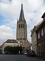 Doesburg, church: de Martinikerk
 -
 Doesburg, monumental house
 -
 Doesburg, monumental house
 -
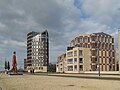 Doesburg, modern architecture


References
- ^ "Samenstelling" [Members] (in Dutch). Gemeente Doesburg. Archived from the original on 11 September 2014. Retrieved 23 June 2014.
{{cite web}}: Unknown parameter|deadurl=ignored (|url-status=suggested) (help) - ^ "Kerncijfers wijken en buurten 2020" [Key figures for neighbourhoods 2020]. StatLine (in Dutch). CBS. 24 July 2020. Retrieved 19 September 2020.
- ^ "Postcodetool for 6981BH". Actueel Hoogtebestand Nederland (in Dutch). Het Waterschapshuis. Retrieved 23 June 2014.
- ^ "Bevolkingsontwikkeling; regio per maand" [Population growth; regions per month]. CBS Statline (in Dutch). CBS. 1 January 2021. Retrieved 2 January 2022.
External links
- Official website
- many sourced quotes and facts of Theo van Doesburg in: De Stijl 1917-1931 - The Dutch Contribution to Modern Art, by H.L.C. Jaffé; J.M. Meulenhoff, Amsterdam 1956
Places adjacent to Doesburg | ||||||||||||||||
|---|---|---|---|---|---|---|---|---|---|---|---|---|---|---|---|---|
| ||||||||||||||||

| International | |
|---|---|
| National | |
| Geographic | |