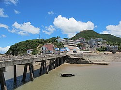
Dongtou, Wenzhou
You can help expand this article with text translated from the corresponding article in Chinese. (April 2015) Click [show] for important translation instructions.
|
This article needs additional citations for verification. (June 2018) |
Dongtou
洞头区 | |
|---|---|
 Dongtou | |
| Coordinates: 27°50′10″N 121°09′25″E / 27.836°N 121.157°E | |
| Country | People's Republic of China |
| Province | Zhejiang |
| Prefecture-level city | Wenzhou |
| Area | |
| • Total | 2,700.3 km2 (1,042.6 sq mi) |
| • Land | 100.3 km2 (38.7 sq mi) |
| • Water | 2,600 km2 (1,000 sq mi) |
| Population (2012)[1] | |
| • Total | 130,600 |
| • Density | 1,302.1/km2 (3,372/sq mi) |
| Time zone | UTC+8 (China Standard) |
| Website | www |
(simplified Chinese: 洞头区; traditional Chinese: 洞頭區; pinyin: Dòngtóu Qū) is a district consisting of 168[1] islands in the East China Sea, and is under the jurisdiction of prefecture-level city of Wenzhou, in southern Zhejiang province, China. It has a total area of 2,700.3 km2 (1,042.6 sq mi), of which 100.3 km2 (38.7 sq mi) is land, and, as of 2012[update], had a population of 130,600.[1] It was known as Dongtou County (洞头县) until 2 September 2015, when, with the approval of the State Council, it was converted to a district.
Economy
Dongtou possesses the second-largest fishery in Zhejiang, reaching an area of about 4,800 km2 (1,900 sq mi),[1] and is known as the "Hijiki capital of China" (中国羊栖菜之乡) as well as the "Seaweed capital of Zhejiang" (浙江紫菜之乡).[1]
References
External links

