Favrskov Municipality
Favrskov Municipality
Favrskov Kommune | |
|---|---|
 | |
 Favrskov Municipality | |
| Country | Denmark |
| Region | Central Denmark |
| Seat | Hinnerup |
| Government | |
| • Mayor | Lars Storgaard (A) |
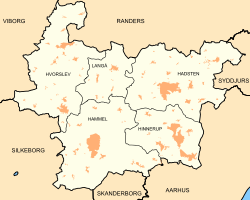
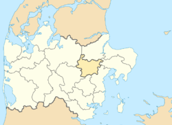
Favrskov Municipality (Template:Lang-da, Template:IPA-da) is a municipality in Region Midtjylland in Denmark north of Aarhus and is a part of the Aarhus area. According to Municipal and Regional Key Figures it covers an area of 540.25 km2 (208.59 square miles) and has a population of 47,177 (1 April 2014).
The largest towns within the municipality are Hadsten, Hinnerup and Hammel and Favrskov Municipality is considered part of the East Jutland metropolitan area with 1.2 million inhabitants in total.[1]
On 1 January 2007 the Favrskov Municipality was created as the result of Kommunalreformen ("The Municipal Reform" of 2007), consisting of the former municipalities of Hadsten, Hammel, Hinnerup, and Hvorslev, as well as the southern part of the former Langå Municipality.
According to Danmark Statistiks, from 2005 to 2009, this was the third-fastest growing municipality out of 98.
Sister cities
The following cities are twinned with Hadsten and Hinnerup:[2]
References
- ^ "Archived copy" (PDF). Archived from the original (PDF) on February 25, 2009. Retrieved February 6, 2016.
{{cite web}}: Unknown parameter|deadurl=ignored (|url-status=suggested) (help)CS1 maint: archived copy as title (link) - ^ "City of Saarijärvi" (in Norwegian). City of Saarijärvi. Archived from the original on 2013-12-06. Retrieved 2012-06-15.
{{cite web}}: Unknown parameter|deadurl=ignored (|url-status=suggested) (help)
- Municipal statistics: NetBorger Kommunefakta, delivered from KMD aka Kommunedata (Municipal Data)
- Municipal mergers and neighbors: Eniro new municipalities map


