Hucqueliers
- العربية
- Asturianu
- 閩南語 / Bân-lâm-gú
- Brezhoneg
- Català
- Cebuano
- Čeština
- Deutsch
- Español
- Euskara
- Français
- Bahasa Indonesia
- Italiano
- Қазақша
- Kurdî
- Latina
- Lëtzebuergesch
- Magyar
- Malagasy
- مصرى
- Bahasa Melayu
- Nederlands
- Нохчийн
- Occitan
- Picard
- Piemontèis
- Polski
- Português
- Română
- Русский
- Simple English
- Slovenčina
- Svenska
- Татарча / tatarça
- Українська
- Vèneto
- Tiếng Việt
- Winaray
- Zazaki
- 中文
This is an old revision of this page, as edited by Tbennert (talk | contribs) at 09:29, 6 November 2016 (→top: update for new French regions, replaced: Nord-Pas-de-Calais → Hauts-de-France using AWB). The present address (URL) is a permanent link to this revision, which may differ significantly from the current revision.
Hucqueliers | |
|---|---|
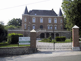
 Château | |
| Country | France |
| Region | Hauts-de-France |
| Department | Pas-de-Calais |
| Arrondissement | Montreuil |
| Canton | Hucqueliers |
| Intercommunality | Communauté de communes du Canton d'Hucqueliers et environs |
| Government | |
| • Mayor (2001–2008) | Serge Bordzakian |
| Area 1 | 7.62 km2 (2.94 sq mi) |
| Population (2006) | 591 |
| • Density | 78/km2 (200/sq mi) |
| Time zone | UTC+01:00 (CET) |
| • Summer (DST) | UTC+02:00 (CEST) |
| INSEE/Postal code | 62463 /62650 |
| Elevation | 92–172 m (302–564 ft) (avg. 94 m or 308 ft) |
| 1 French Land Register data, which excludes lakes, ponds, glaciers > 1 km2 (0.386 sq mi or 247 acres) and river estuaries. | |
Hucqueliers is a commune in the Pas-de-Calais department in the Hauts-de-France region of France.
Geography
Situated some 10 miles (16 km) northeast of Montreuil-sur-Mer at the D148 and D128 crossroads.
Population
| Year | 1962 | 1968 | 1975 | 1982 | 1990 | 1999 | 2006 |
|---|---|---|---|---|---|---|---|
| Population | 521 | 555 | 558 | 528 | 539 | 505 | 591 |
| From the year 1962 on: No double counting—residents of multiple communes (e.g. students and military personnel) are counted only once. | |||||||
History
An important castle was built here in 1231 by the Count of Boulogne. Hucqueliers was the centre of resistance during the Lustucru revolt in 1662.
Places of interest
- The chateau, now an educational establishment.
- The church of St.André, dating from the fifteenth century.
- The eighteenth century Manoir de la Longeville.
See also
References
External links
This Pas-de-Calais geographical article is a stub. You can help Wikipedia by expanding it. |
- Articles with short description
- Short description is different from Wikidata
- Pages using infobox settlement with image map1 but not image map
- Pages using infobox settlement with no coordinates
- Pages using infobox French commune with unknown parameters
- France articles requiring maintenance
- Commons category link from Wikidata
- All stub articles
- Pages using the Kartographer extension

