Landsmeer
Appearance
Landsmeer | |
|---|---|
 Landsmeer town centre | |
 Location in North Holland | |
| Country | Netherlands |
| Province | North Holland |
| Government | |
| • Body | Municipal council |
| • Mayor | Astrid Nienhuis (VVD) |
| Area | |
• Total | 26.50 km2 (10.23 sq mi) |
| • Land | 22.53 km2 (8.70 sq mi) |
| • Water | 3.97 km2 (1.53 sq mi) |
| Elevation | −1 m (−3 ft) |
| Population (January 2021)[4] | |
• Total | 11,565 |
| • Density | 513/km2 (1,330/sq mi) |
| Time zone | UTC+1 (CET) |
| • Summer (DST) | UTC+2 (CEST) |
| Postcode | 1120–1127, 1451 |
| Area code | 020 |
| Website | www |
Landsmeer () is a municipality and a town in the Netherlands, in the province of North Holland.
Population centres
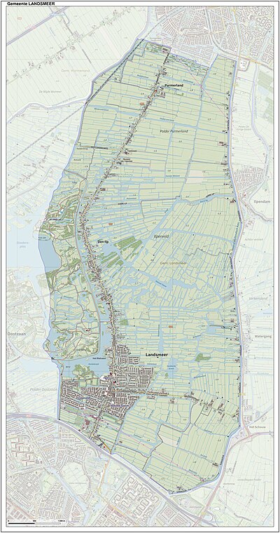
The municipality of Landsmeer consists of the three villages: Den Ilp, Landsmeer, Purmerland.
Topography
Dutch topographic map of the municipality of Landsmeer, June 2015
Local government
The municipal council of Landsmeer consists of 15 seats, which are divided as follows:
Town twinning
Landsmeer is twinned with the following towns:
 Bergneustadt since 1968
 Châtenay-Malabry, Hauts-de-Seine, since 1986
- Bergneustadt and Châtenay-Malabry are twinned since 1967
References
- ^ "College van burgemeester en wethouders" (in Dutch). Gemeente Landsmeer. Retrieved 13 March 2014.
{{cite web}}: Unknown parameter|trans_title=ignored (|trans-title=suggested) (help) - ^ "Kerncijfers wijken en buurten 2020" [Key figures for neighbourhoods 2020]. StatLine (in Dutch). CBS. 24 July 2020. Retrieved 19 September 2020.
- ^ "Postcodetool for 1121XC". Actueel Hoogtebestand Nederland (in Dutch). Het Waterschapshuis. Retrieved 13 March 2014.
{{cite web}}: Cite has empty unknown parameter:|trans_title=(help) - ^ "Bevolkingsontwikkeling; regio per maand" [Population growth; regions per month]. CBS Statline (in Dutch). CBS. 1 January 2021. Retrieved 2 January 2022.
External links
 Media related to Landsmeer at Wikimedia Commons
- Official website


