
Lovech
Lovech
Ловеч | |
|---|---|
 The Covered Bridge of Lovech | |
 Coat of arms | |
| Country | |
| Provinces (Oblast) | Lovech |
| Government | |
| • Mayor | Mincho Kazandzhiev |
| Elevation | 200 m (700 ft) |
| Population (15.12.2004) | |
| • Total | 50,666 |
| Time zone | UTC+2 (EET) |
| • Summer (DST) | UTC+3 (EEST) |
| Postal Code | 5500 |
| Area code | 068 |

Lovech (Bulgarian: Ловеч) is a town in north-central Bulgaria with a population of about 50,000. Lovech is the administrative centre of Lovech Province and of the subordinate Lovech municipality, and is located 150 km from the capital city of Sofia. Near Lovech are the towns of Pleven, Troyan and Teteven.
Geography
Lovech is situated in the Forebalkan area of northern Bulgaria, on both sides of the river Osam, and unifies both mountainous and plain relief. The eastern part of the town is surrounded by a 250 m high plateau, where the largest park in Lovech, Stratesh, is located, and the southwestern part is surrounded by the hills Hisarya and Bash Bunar. In the northwest the relief gradually changes to the plains of the neighbouring Pleven Province. The average altitude of Lovech is about 200 m above mean sea level. The highest point of the town is Akbair Hill at 450 m.
Lovech has a beautiful location, with many parks and places to rest. In Stratesh Park, the highest place in the town, there are a great number of lilac bushes, easily seen from the whole town, which are a wonderful view in the spring. Due to this, Lovech is well-known as the town of the lilacs.
History
Ancient history
Lovech is one of the oldest towns in Bulgaria. Traces of human activities from very ancient times were found in the region, mainly in the caves near the town. The reason was the comfortable location between the mountains and the flat country, and the presence of a river.
The first inhabitants of the town were the Thracian tribe of the Meldi, whose traces date as back to the 4th-3rd century BC. They founded their capital, called Melta, in the area, which was situated at the place of today's neighbourhood and architecture reserve Varosha. Later, when the Balkans were occupied by the Roman Empire, a military station called Prezidium was founded near the modern town, which was situated at an important strategic position on one of the main Roman roads. Parts of this road are to be seen in the territory of Lovech today.
Middle Ages
The former Roman citadel Hisarya, which is situated on the hill of the same name, was the place where in 1187 the peace treaty between Bulgaria and the Byzantine Empire was signed and the independence of Bulgaria was officially declared, marking the restoration of the Bulgarian Empire. In the 12th century Lovech was a great trade centre and one of the most famous towns in Bulgaria.
The Turkish invasion in the middle of the 14th century did not pass the town, but the Hisarya fortress was captured last of all, in 1446, although for a long time after that the town enjoyed some privileges such as a prohibition on Turkish people to settle in the town or to take Bulgarian children as janissaries.
Ottoman rule
In the 17th century Lovech (Lofça in Turkish was once again an important trade centre and one of the richest towns in Bulgaria, a reason for the town being called Altan Lovech (Golden Lovech, from Turkish) at the time.
1784 is the most horrible year in the history of the town, when it was almost totally burnt and destroyed by a Turkish army. From 20,000 citizens at the time there were only 4,600 survivors.

In the times of revolutionary organisations against the Ottoman enslavers, Lovech was the centre of operations of the Internal Revolutionary Organisation of Vasil Levski, called the Secret Revolutionary Committee. He was arrested by the Turkish military in a village near Lovech called Kakrina and later hanged in Sofia. The biggest museum of Vasil Levski in Bulgaria containing many personal items such as notebooks, clothes and weapon is situated in the old town part of Lovech.
Between 1872 and 1874, the Bulgarian master-builder Nikola Fichev, known also as Kolyu Ficheto, built the famous Covered Bridge (Покрит мост) over the river Osam, the only one of its kind in the Balkans. The bridge was burned out in 1925, but rebuilt in 1931. Now it connects the new and the old part of the town and it's full of cafes, small restaurants and many souvenir shops.
During the Russo-Turkish War of 1877-78, an important battle was held at Lovech, known as the Battle of Lovcha.
Cultural and natural sights
- The Covered Bridge by Kolyu Ficheto
- The Hisarya Fortress
- The monument of Vasil Levski
- The monuments to Russian soldiers killed in the Russo-Turkish War of 1877-78
- The Varosha old town part
- Stratesh Park with the biggest zoo in the province
- Bash Bunar Park
- The baroque buildings in the town's central parts
- The Varosha architectural and historical reserve, with Drasova and Rashova memorial houses
Theatres
- Lovech Drama Theatre
- Theatre by the Nauka Community Centre
- The summer theatre in Stratesh Park
Museums
- Museum of Vasil Levski
- Lovech Historical Museum
- Drasova Memorial House
- Rashova Memorial House
Sports
- PFC Litex Lovech, one of Bulgaria's top football clubs
- Osam, a men's handball club
- Lovech '98, a women's handball club
- Eagles, a baseball club
- A wrestling club
- A kyokushin karate club
- Progress, a chess club
Famous people born in or connected with Lovech
- Joseph I of Bulgaria — Bulgarian exarch
- Georgi Ivanov — the first Bulgarian cosmonaut
- Dimitar Dimov — Bulgarian author
- Simeon Djankov — economist
- Anastas Ishirkov — noted geographer
- Benyo Tsonev — important figure of Bulgarian linguistics
- Todor Kirkov — revolutionary
- Hristo Karpachev — poet, partisan
- Panayot Pipkov — composer
- Lyubomir Pipkov — composer
Events
Partner towns
Honour
Melta Point on Livingston Island in the South Shetland Islands, Antarctica is named after the ancient Melta.
Gallery
-
 Central Lovech.
 -
 Central Lovech.
 -
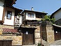 Bulgarian National Revival quarter, Varosha.
 -
 The ancient fortress.


External links
- Official site of Lovech
- Lovech Party Fest Fan Site
- Tourist information and accommodation
- Guide to Lovech district — cities, villages, resorts
- All about the town and the municipality of Lovech
- Article at Visit to Bulgaria
- A large article about Lovech with many pictures at BulgarianProperties.com
- Pictures from Lovetch
- Ezikovata — the oldest foreign language school in Bulgaria, unofficial web site
- Lovech on youtube
- Неофициален сайт на град Ловеч
- [http://lovechtoday.com/ News and information from Lovech and area, business navigator, pictures from Lovech
