
Mahatma Gandhi Marine National Park
| Mahatma Gandhi Marine National Park (M.G.M.N.P) | |
|---|---|
| Location | Andaman Islands, India |
| Nearest city | Wandur |
| Area | 281.5 km2 (108.7 sq mi) |
| Established | 1983 |
Nickname: North Mahatma Gandhi Islands | |
|---|---|
 Labyrinth Islands Location of Labyrinth Islands | |
| Geography | |
| Location | Bay of Bengal |
| Coordinates | 11°32′N 92°36′E / 11.53°N 92.60°E |
| Archipelago | Andaman Islands |
| Adjacent to | Indian Ocean |
| Administration | |
| Demographics | |
| Population | 0 |
| Additional information | |
| Time zone | |
| PIN | 744103[1] |
| Telephone code | 031927 [2] |
| Official website | www |
Mahatma Gandhi Marine National Park is a national park of India near Wandoor on the Andaman Islands. It belongs to the South Andaman administrative district, part of the Indian union territory of Andaman and Nicobar Islands.[4]
History
The park was created 24 May 1983 under the Wildlife Protection Act of 1972 to protect marine life such as the corals and nesting sea turtles prevalent in the area. It was placed under the protection of the Chief Wildlife Warden of the forest department of the Andaman & Nicobar Islands.[5]
Geography
There are 2 major island groups in the park: the Labyrinth Islands and the Twin Islands The islands are situated 16 km (10 mi) south from Port Blair. The marine park covers 281.5 km² made up of 17 islands and the open sea creeks running through the area. There is a chance for ecotourism on the islands Jolly Buoy and Red Skin [6][7][8] The islands belongs to the Rutland Archipelago and are located between Rutland Island and South Andaman Island.
Ecosystems
Most of the coral reefs in the park are fringing reefs. The type and composition of vegetation varies from island to island. Most notably there you can see a difference between the tourist islands which suffer more anthropocentric change and others which do not. There are also some islands more isolated or protected from the effects of weather in the Bay of Bengal. Tarmugli, the largest island, is covered with thick mangrove vegetation, sand covered beaches, uprooted trees and sheet rocks.[9] Twin Islands are an important breeding ground for turtles within the park.
List of Islands
Mahatma Gandhi Marine National Park has some 20 islands and rocks.
| Island | Sobriquet | type | Location | Area (hectares) |
Coastline (km) | Length (km) | Width (km) | elevation (m) | |
|---|---|---|---|---|---|---|---|---|---|
| 1 | Alexandra | island | 11°34′36″N 92°36′38″E / 11.57667°N 92.61056°E | 408.8 | 9.3 | 2.5 | 2.00 | 0.00 | |
| 2 | Bell | island | 11°34′08″N 92°33′57″E / 11.56889°N 92.56583°E | 6.7 | 1 | 0.38 | 0.21 | 0.00 | |
| 3 | Boat | island | 11°31′35″N 92°33′38″E / 11.52639°N 92.56056°E | 247.6 | 7.71 | 2.7 | 1.3 | 27.00 | |
| 4 | Chester | island | 11°33′06″N 92°35′10″E / 11.55167°N 92.58611°E | 6.6 | 1.00 | 0.33 | 0.33 | 0.00 | |
| 5 | Grub | island | 11°33′06″N 92°35′10″E / 11.55167°N 92.58611°E | 2.3 | 0.7 | 0.13 | 0.25 | 24.00 | |
| 6 | Hobday | island | 11°32′40″N 92°36′42″E / 11.54444°N 92.61167°E | 367.80 | 10.50 | 3.23 | 1.91 | 0.00 | |
| 7 | Jolly Buoy | island | 11°30′26″N 92°36′41″E / 11.50722°N 92.61139°E | 18.80 | 2.50 | 1.10 | 0.20 | 45.00 | |
| 8 | Malay | island | 11°31′48″N 92°36′12″E / 11.53000°N 92.60333°E | 80.20 | 4.25 | 1.71 | 0.61 | 68.00 | |
| 9 | Pluto | island | 11°33′06″N 92°35′10″E / 11.55167°N 92.58611°E | 13.3 | 1.81 | 0.75 | 0.22 | 49.00 | |
| 10 | Red Skin | island | 11°33′00″N 92°35′30″E / 11.55000°N 92.59167°E | 428.20 | 12.39 | 4.9 | 1.4 | 46.00 | |
| 11 | Riflemen | island | 11°30′50″N 92°38′40″E / 11.51389°N 92.64444°E | 2.40 | 0.70 | 0.27 | 0.15 | 0.00 | |
| 12 | Snob | island | 11°35′55″N 92°34′27″E / 11.59861°N 92.57417°E | 17.65 | 2.18 | 0.96 | 0.26 | 75.00 | |
| 13 | Tarmugli | island | 11°34′30″N 92°33′00″E / 11.57500°N 92.55000°E | 1216.70 | 20.00 | 5.5 | 3.8 | 78.00 | |
| 14 | West Twin | island | 11°33′06″N 92°35′10″E / 11.55167°N 92.58611°E | 38.70 | 0.00 | 0.00 | 0.00 | 48.00 | |
| 15 | East Twin | island | 11°33′06″N 92°35′10″E / 11.55167°N 92.58611°E | 20.00 | 0.00 | 0.00 | 0.00 | 44.00 | |
| 16 | North Hobday | island | 11°33′30″N 92°36′30″E / 11.55833°N 92.60833°E | 17.80 | 1.93 | 0.00 | 0.00 | 0.00 | |
| 17 | ? | island | 11°33′38″N 92°35′55″E / 11.56056°N 92.59861°E | 0.50 | 0.00 | 0.00 | 0.00 | 0.00 | |
| 18 | ? | island | 11°32′22″N 92°35′02″E / 11.53944°N 92.58389°E | 10.10 | 1.77 | 0.00 | 0.00 | 0.00 | |
| Mahatma Gandhi Marine National Park Islands | Archipelago | 11°32′22″N 92°35′02″E / 11.53944°N 92.58389°E | 2904.5 | 0.00 |
Administration
Politically, all islands are part of Port Blair Taluk.[10]
Demographics
The islands are on uninhabited land, but there is a population of 7300 living in 10 adjacent villages (Mainly Manglutan and Wandur)
Image gallery
-
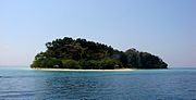 Jolly Buoy Island, one of the 20 islands in the national park.
 -
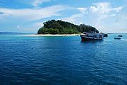 Mahatma Gandhi Marine National Park near Port Blair, Andaman Islands
 -
 Mahatma Gandhi Marine National Park during sunset .


References
- ^ "A&N Islands - Pincodes". 22 September 2016. Archived from the original on 23 March 2014. Retrieved 22 September 2016.
{{cite web}}: Unknown parameter|deadurl=ignored (|url-status=suggested) (help) - ^ "STD Codes of Andaman and Nicobar". allcodesindia.in. Retrieved 23 September 2016.
- ^ "Sailing Directions (enroute) | India and the Bay of Bengal" (Document). National Geospatial-intelligence Agency, United States Government. 2014.
{{cite document}}: Unknown parameter|accessdate=ignored (help); Unknown parameter|issue=ignored (help); Unknown parameter|url=ignored (help) - ^ "Village Code Directory: Andaman & Nicobar Islands" (PDF). Census of India. Retrieved 16 January 2011.
- ^ [1]
- ^ [2]
- ^ Jolly Buoy info
- ^ red skin island
- ^ Tarmugli
- ^ "DEMOGRAPHIC – A&N ISLANDS" (PDF). andssw1.and.nic.in. Retrieved 23 September 2016.
 Andaman and Nicobar Islands travel guide from Wikivoyage
- The Mahatma Gandhi Marine National Park
- 11 Status of Coral Reefs of Mahatma Gandhi Marine National Park, Wandoor, Andamans by K Dorairaj and R. Soundararajan