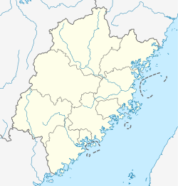
Mawei, Fuzhou
Mawei
马尾区 | |
|---|---|
 Qingzhou Bridge spans the Min River, connecting Mawei District with Changle City | |
| Coordinates: 26°00′41″N 119°27′25″E / 26.01139°N 119.45694°E | |
| Country | People's Republic of China |
| Province | Fujian |
| Prefecture-level city | Fuzhou |
| Time zone | UTC+8 (China Standard) |
Mawei (simplified Chinese: 马尾; traditional Chinese: 馬尾; pinyin: Mǎwěi; Foochow Romanized: Mā-muōi) is a district of Fuzhou, Fujian province, People's Republic of China.
Mawei District is located on the left (northern) shore of the Min River, between Fuzhou's urban core and the coast of the East China Sea. The district also includes Langqi Island formed by the two main branches of the Min River as it flows into the sea.
Mawei District is famous for its historical Mawei Navy Yard, with a modern shipyard operating on the site.
The Min River separates Mawei District from Changle City on the river's southern bank. Qingzhou Bridge spans the river, connecting Mawei's main urban center (the Mawei Town / Luoxing Subdistrict area) with Changle.
Administrative division

Subdistricts:
- Luoxing Subdistrict (罗星街道)
Towns:

