
Mingoval
- العربية
- Asturianu
- 閩南語 / Bân-lâm-gú
- Brezhoneg
- Català
- Cebuano
- Deutsch
- Eesti
- Español
- Euskara
- Français
- Bahasa Indonesia
- Italiano
- Қазақша
- Kurdî
- Latina
- Lëtzebuergesch
- Magyar
- Malagasy
- مصرى
- Bahasa Melayu
- Nederlands
- Нохчийн
- Occitan
- Picard
- Piemontèis
- Polski
- Português
- Română
- Simple English
- Slovenčina
- Svenska
- Татарча / tatarça
- Українська
- Vèneto
- Tiếng Việt
- Winaray
- Zazaki
- 中文
From Wikipedia, the free encyclopedia
This is an old revision of this page, as edited by Tbennert (talk | contribs) at 09:40, 6 November 2016 (→top: update for new French regions, replaced: Nord-Pas-de-Calais → Hauts-de-France (2) using AWB). The present address (URL) is a permanent link to this revision, which may differ significantly from the current revision.
Place in Hauts-de-France, France
Mingoval | |
|---|---|
 | |
Location of Mingoval  | |
| Country | France |
| Region | Hauts-de-France |
| Department | Pas-de-Calais |
| Arrondissement | Arras |
| Canton | Aubigny-en-Artois |
| Intercommunality | Communauté de communes de l'Atrébatie |
| Government | |
| • Mayor (2008–2014) | Jacques Deneux |
| Area 1 | 3.79 km2 (1.46 sq mi) |
| Population (2006) | 206 |
| • Density | 54/km2 (140/sq mi) |
| Time zone | UTC+01:00 (CET) |
| • Summer (DST) | UTC+02:00 (CEST) |
| INSEE/Postal code | 62574 /62690 |
| Elevation | 109–157 m (358–515 ft) (avg. 125 m or 410 ft) |
| 1 French Land Register data, which excludes lakes, ponds, glaciers > 1 km2 (0.386 sq mi or 247 acres) and river estuaries. | |
Mingoval is a commune in the Pas-de-Calais department in the Hauts-de-France region of France.
Geography
Mingoval is situated 12 miles (19 km) northwest of Arras, on the D73 road.
Population
| 1962 | 1968 | 1975 | 1982 | 1990 | 1999 | 2006 |
|---|---|---|---|---|---|---|
| 198 | 201 | 196 | 183 | 207 | 208 | 206 |
| Census count starting from 1962: Population without duplicates | ||||||
Places of interest
- The church of St.Liévin, dating from the eighteenth century.
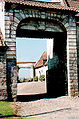
- The seventeenth century cemetery entrance.
- An old farmhouse.
See also
References
External links
Wikimedia Commons has media related to Mingoval.
-
 Ancient entrance to the old farm
 -
 The churchyard entrance
 -
 The church spire
 -
 Architectural detail
 -
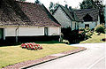 Typical regional houses
 -
 The church


| Authority control databases: National |
|---|
This Arras arrondissement, Pas-de-Calais geographical article is a stub. You can help Wikipedia by expanding it. |
Retrieved from "https://en.wikipedia.org/w/index.php?title=Mingoval&oldid=748100027"
Hidden categories:
- Articles with short description
- Short description is different from Wikidata
- Pages using infobox settlement with image map1 but not image map
- Pages using infobox settlement with no coordinates
- Pages using infobox French commune with unknown parameters
- France articles requiring maintenance
- Commons category link from Wikidata
- Articles with BNF identifiers
- Articles with BNFdata identifiers
- All stub articles
- Pages using the Kartographer extension