
Bonin Islands

The Ogasawara Islands (小笠原諸島, Ogasawara Shotō) are an archipelago of over 30 subtropical and tropical islands, some 1,000 km directly south of Tokyo, Japan. Administratively, they form one of the villages of Tokyo. The islands are also known as the Bonin Islands. The total area of the islands is 84 km².
Ogasawara Village, which has its population on the only inhabited islands of the archipelago (Chichi-jima (父島) and Haha-jima (母島)), serves as the local government for the archipelago. Ogasawara Subprefecture includes what is within Ogasawara Village. There is also a Japan Self-Defense Forces base on Iwo Jima with a staff of about 400.
Island subgroups
The Ogasawara Islands consists of four subgroups, including the Volcano Islands, which are listed along with their main islands:
- Mukojima Group (聟島列島 Mukojima Rettō) - formerly Parry Group
- Mukojima (聟島, literally: Bridegroom Island)
- Yomejima (嫁島, literally: Bride Island)
- Nakōdo-jima or Nakadachijima (媒島, literally: Go-between Island)
- Kitanojima (北ノ島 or 北島, literally: Northern Island)
- Chichijima Group (父島列島 Chichijima Rettō) - formerly Beechey Group
- Chichijima (父島, literally: Father Island),
- Anijima (兄島, literally: Elder Brother Island)
- Otōtojima (弟島, literally: Younger Brother Island)
- Hahajima Group (母島列島 Hahajima Rettō) - formerly Baily Group
- Hahajima (母島, literally: Mother Island)
- Anejima (姉島, literally: Elder Sister Island)
- Imōtojima (妹島, literally: Younger Sister Island)
- Volcano Islands Group (火山列島 Kazan Rettō)
- Kita Iwo Jima (北硫黄島 Kitaiōjima or Kitaiōtō, literally: North Sulphur Island)
- Iwo Jima (硫黄島 Iōjima or Iōtō, literally: Sulphur Island)
- Minami Iwo Jima (南硫黄島 Minamiiōjima or Minamiiōtō, literally: South Sulphur Island)
- Single Isolated Island, west of Hahajima Group and North of Volcano Islands Group:
- Nishino shima (西之島, literally: Western Island, also: Rosario Island)
- Isolated Remote Islands, not geographically part of Ogasawara Islands, but administratively part of Ogasawara Village:
- Okinotorishima (沖ノ鳥島 or 沖鳥島, literally: Remote Bird Island)
- Minamitorishima (南鳥島, literally: Southern Bird Island, also: Marcus Island)
The southernmost (uninhabited) group is known as the Volcano Islands. 700 km further south is Okino Torishima, and 1,900 km further east is Minami Torishima.
-
 Chichijima
 -
 Hahajima
 -
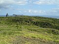 Mukojima
 -
 Minamijima, a small island in Chichijima group
 -
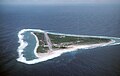
 Iwo Jima
 -
 Minami Iwo Jima
 -
 Kita Iwo Jima
 -
 Minamitorishima


History

Discovery and colonization
The first European discovery of the islands is said to have taken place in 1543, by the Spanish explorer Bernardo de la Torre.[1]
- Bunroku 1 (1592): Ogasawara Sadayori claims to have discovered the Bonin Islands, and the territory was granted to him as a fief by Toyotomi Hideyoshi.[2]
- Kanbun 10 (1670): The islands are discovered by the Japanese when a ship bound for Edo from Kyushu is blown off course by a storm.[3]
- Enpō 3 (1675): The islands are explored by shogunate expedition, following up "discovery" in Kanbun 10. The islands are claimed as a territory of Japan.[4]
- Bunkyū 1 (January 1862): The islands are re-confirmed as a territory of Japan, following "discovery" of the islands in Kanbun 10 (1670) and a shogunate expedition to the islands in Enpō 3 (1675).[5]
The islands remained uninhabited until Nathaniel Savory, an American, landed on the island of Chichijima in 1830 and formed the first colony there.[6] In 1853, Commodore Perry visited the islands and bought property at Port Lloyd from Savory for $50.[2] To date, Nathaniel's descendants still live on the island.[7]
These groups were collectively called Islas del Arzobispo (Archbishop Islands) in Spanish sources of the 18th-19th century. Japanese maps at the time seem to have been rather inaccurate and therefore considered by some[8] to be deliberately misleading. It is thought that this was an attempt to discourage colonization attempts by foreign nations. Frederick William Beechey used the Spanish name as late as 1831 and believed that the Japanese Boninsima referred to entirely different islands.[9]
World War II to present
During World War II, most of the inhabitants were evacuated to the mainland. There was a Japanese military base on Chichijima, whose officer in charge, Major Sueo Matoba (的場 末男, Matoba Sueo), was known for performing cannibalism and other acts on prisoners of war and was executed for his crimes after the war.[10][11] Future President George H. W. Bush's plane crashed in the ocean near Chichijima, but he was rescued by an American submarine. The Battle of Iwo Jima, one of the fiercest battles of World War II, was fought here in 1945.
The islands were occupied by the U.S. Navy from 1945, at which point the inhabitants of "Western" (mainly of mixed Anglo American or European, Filipino and Polynesian descent) were allowed back.[12] The islands were returned to Japan in 1968, at which time Japanese evacuees were allowed to return.
Now nearly all inhabitants, including those of Western ancestry, are Japanese citizens, and the Japanese language is used. Research indicates that an English-lexified pidgin (creole) was spoken on the islands during the 19th century.[13] During the 20th century, islanders of Western descent increasingly mixed Japanese with island English, resulting in a mixed language that can still be heard today.[14] Younger speakers are monolingual in a variety of Japanese closely resembling the Tokyo standard.[15] A bilingual dictionary, Talking Dictionary of the Bonin Islands Language (with CD-ROM), was published in 2005.[16]
A 25m-diameter radio telescope is located in Chichijima, which is one of the stations of the VLBI Exploration of Radio Astrometry (VERA) project, and is operated by the National Astronomical Observatory of Japan.
Name
In Japanese, the archipelago is called Ogasawara Islands (小笠原諸島, Ogasawara shotō). The common English name is Bonin Islands, from bunin, an archaic reading of 無人 (mujin), that means "no people" or "uninhabited."
Recent developments
Japan's Ministry of the Environment and Ministry of Agriculture, Forestry and Fisheries have entered the Ogasawara Islands as a candidate World Heritage Site on the premise that the islands meet the three listed criteria for geology, ecosystems, and biodiversity.[17]
The giant squid (genus Architeuthis) was filmed off the Ogasawara Islands for the first time in the wild on September 27, 2005, and was captured in December 2006.[18]
Fictional references
The Ogasawara Islands have been referenced in a number of works of fiction. The Sevii Islands from Pokémon Fire Red and Leaf Green are based on the Bonin Islands. In the Godzilla films Monster Island is sometimes located in the chain. In an English-dubbed version, it is referred to as "Ogasawara Island" as if it were a lone island of that name. In the television series The Super Dimension Fortress Macross, a fictional island in the chain, South Ataria Island (which would have laid at the southernmost position in the chain, surpassing Minami Iwo Jima), is the landing site of the SDF-1 Macross.[19] In the 1963 film Matango, a luxury yacht is set adrift and lands on an island. Upon approaching the island one of the crew members shouts: "I wonder if it's the Bonin Islands?"[20] The English subtitles for the film misspell Bonin "Bonan".
Transportation
One can get from the main Japanese islands to Chichijima by way of the Ogasawara Maru liner, run by Ogasawara Marine Transportation. The ship leaves from Takeshiba port in Tokyo Bay, and the trip takes around 25.5 hours (in good weather). There are four or five crossings each month. The Ogasawara Maru is a 6,700 ton vessel, 131m long, with a capacity of 1,031 passengers.[21] To get to Hahajima, one must first get to Chichijima, and then cross by the liner Hahajima Maru.
Because a trip from the main Japanese islands to the Ogasawaras is very difficult, when people get severely ill or otherwise have an emergency, word is conveyed to Iwo Jima Japan Maritime Self Defense Force post, and a helicopter is sent to the islands. Emergencies can also be handled from the main Japanese islands by Japan Air Self-Defense Force airplanes or the Maritime Self Defense Force base in Iwakuni can convey evacuees to the main islands by seaplane, the ShinMaywa US-1. This seaplane is also used to transport the Tokyo governor and other VIPs.
Ogasawara Village operates a bus service on Chichijima and elderly passengers may use a "silver pass." There is also a sightseeing taxi service, a rental car company, motorized scooter rental services, a bike rental service, and other amenities. Bringing one's own automobile onto the island is extremely difficult and costly.
Issues with improved transportation
The world's first 'techno superliner', the Super Liner Ogasawara (which was to be commissioned in 2006), with a maximum speed of 70 km/h, 14,500 tons gross tonnage, was expected to shorten the voyage to Ogasawara to about 17 hours and carry up to 740 passengers.[22] However, the project was canceled in July 2005 due to rising fuel prices and the loss of ¥2 billion[23].
The Ogasawara Islands have no airport, and there is no prospect for one being constructed. However, there was talk for several decades of building one[citation needed]. Anijima and Chichijima were once designated possible construction sites, but because there are numerous valuable, rare, or endangered plant species forming a unique ecosystem in the vicinity of the proposed sites, issues of nature conservation were raised. Although construction of an airport was desired by some, a desire to keep the natural beauty of the islands untouched created a movement to block it. The airport issue was quite controversial on the islands.[24]
Geology
Formation
The Ogasawara Islands were formed around 48 million years ago. They are a part of the Izu-Bonin-Mariana Arc known geologically as a fore arc. They lie above a subduction zone between the Pacific Plate and the Philippine Plate. The Pacific Plate is subducting under the Philippine Plate, which creates an oceanic trench to the east of the islands. The crust of the Ogasawara (Bonin) Islands was formed by volcanic activity when subduction began 45–50 million years ago, and is composed mostly of an andesitic volcanic rock called boninite, which is rich in magnesium oxide, chromium, and silicon dioxide. The Ogasawara Islands may represent the exposed parts of an ophiolite that has not yet been emplaced on oceanic crust. The rocks of the Volcano Islands are much younger; Iwo Jima is a dormant volcano characterized by rapid uplift and several hot springs.
Most of the islands have steep shorelines, often with sea cliffs ranging from 50 to 100 meters in height, but the islands are also fringed with coral reefs and have many beaches.[25] The highest point lies on South Iwo Jima, at 916m.
Ecology
Ogasawara subtropical moist forests
The Ogasawara Islands form a distinct subtropical moist broadleaf forest ecoregion, with a high degree of biodiversity and endemism. The islands are home to about 500 plant species, of which 43% are endemic. The forests are of three main types:
- Type I: Elaeocarpus-Ardisia mesic forest is found in the moist lowland areas with deep soils. The forests have a closed canopy with a height of about 15 meters, dominated by Ardisia sieboldii. Elaeocarpus photiniaefolius, Pisonia umbellifera, and Pouteria obovata are other important canopy species. These forests were almost completely destroyed by clearing for agriculture before 1945.
- Type II: Distylium-Raphiolepis-Schima dry forest is found in drier lowland and upland sites with shallower soils. It is also a closed-canopy forest, with a 4 to 8 meter canopy composed mostly of Distylium lepidotum, Rhaphiolepis integerrima, Schima mertensiana, Pouteria obovata, and Syzygium buxifolium. The Type II forests can be further subdivided into:
- Type IIa: Distylium-Schima dry forest occurs in cloudy upland areas with fine-textured soils. These forests contain many rare and endemic species, with Pandanus boninensis and Syzygium buxifolium as the predominant trees.
- Type IIb: Raphiolepsis-Livistona dry forest is found in upland areas with few clouds and rocky soils. Rhaphiolepis integerrima is the dominant tree species, along with the fan palm Livistona chinensis var. bonensis, Pandanus boninensis and Ochrosia nakaiana.
- Type III: Distylium-Pouteria scrub forest is found on windy and dry mountain ridges and exposed sea cliffs. These forests have the highest species diversity on the islands. Distylium lepidotum and Pouteria obovata are the dominant species, growing from 0.5 to 1.5 meters tall. Other common shrubs are Myrsine okabeana, Symplocos kawakamii, and Pittosporum parvifolium.
Several bird species are or were endemic to the islands, including the extinct Japanese Woodpigeon (Columba janthina) and the Vulnerable Bonin White-eye (Apalopteron familiare), formerly known as "Bonin Honeyeater". A small bat, Pipistrellus sturdeei is only known in one record and has not been seen since 1915. The Bonin flying fox (Pteropus pselaphon), also called the Bonin fruit bat, is endemic to the islands. It is currently listed as Critically Endangered, and a survey published by the Ogasawara Office of Education in 1999 estimated their number to be around 100.[26]
Flora
Flora has evolved differently on each of the islands. The Ogasawara Islands are sometimes referred to as the Galapagos of the Orient.[27]
Education
Ogasawara Village operates its public elementary and junior high schools.
Tokyo Metropolitan Government Board of Education operates Ogasawara High School [1] on Chichi-jima.
Notes
- ^ Welsch, Bernhard. (2004). "Was Marcus Island Discovered by Bernardo de la Torre in 1543?" Journal of Pacific History, 39:1, 109-122.
- ^ a b Cholmondeley, Lionel Berners. (1915). The History of the Bonin Islands from the Year 1827 to the Year 1876. London: Constable & Co.
- ^ Tanaka, Hiroyuki. (1993). "The Ogasawara Islands in Tokugawa Japan," Kaiji Shi Kenkyuu (Journal of the Maritime History).
- ^ [see above]
- ^ Tanaka, Hiroyuki (1993). "Edo Jidai ni okeru Nihonjin no Mujin Tou (Ogasawara Tou) ni tai-suru Ninshiki" ("The Ogasawara Islands in Tokugawa Japan"). Kaiji Shi Kenkyuu(Journal of the Maritime History). No. 50, June, 1993.
- ^ Asia Society of Japan, Long lecture.
- ^ "父島の宿". Retrieved 2007-09-05.
- ^ Beechey, Frederick William (1831). Narrative of a voyage to the Pacific and Bearing's Strait, to co-operate with the polar expeditions: performed in His Majesty's ship Blossom, under the command of Captain F.W. Beechey, R.N., F.R.S. &c. in the years 1825, 26, 27, 28 (PDF). London: H. Colburn and R. Bentley. pp. 237–240.
- ^ Rein, J. J. (1884). Japan: Travel and Researches, pp.533-534.
- ^ http://www.pegc.us/archive/Articles/welch_naval_MCs.pdf
- ^ "Story of George H. W. Bush World War II Experience." CNN. December 20, 2003.
- ^ Trumbull, Robert. "Bonin Islanders Seek U.S. Tie But Remain International Pawns; Descendants of Americans Ask Citizenship in Vain--Fight Return of Japanese," New York Times. March 11, 1956.
- ^ Long, Daniel (2004). The Last Yankee in the Pacific: Eastern New England Phonology in the Bonin Islands. Duke University Press. doi:10.1215/00031283-79-4-356.
{{cite book}}: Unknown parameter|coauthors=ignored (|author=suggested) (help) - ^ Long, Daniel (2007). English on the Bonin (Ogasawara) Islands. Duke University Press. ISBN 978-0-8223-6671-3.
- ^ linguistic culture
- ^ Long, Daniel (2005). Talking Dictionary of the Bonin Islands Language (with CD-ROM). Nanpo Shinsha. ISBN 978-4861240447.
{{cite book}}: Unknown parameter|coauthors=ignored (|author=suggested) (help) - ^ "Ogasawara Islands - UNESCO World Heritage Centre". Retrieved 2007-09-06.
- ^ "Japanese Researchers Capture Giant Squid". Retrieved 2007-09-06.
- ^ Macross Compendium Atlas Listing
- ^ Matango - 00:17
- ^ "おがさわら丸 (Ogasawara Maru)". Retrieved 2007-09-06.
- ^ "Super High Speed Ship (Techno Super Liner) for Ogasawara Line Naming and Launching Ceremony". Retrieved 2007-08-24.
- ^ "Japan pulls plug on Techno Superliner". Retrieved 2007-08-24.
- ^ McCormack, Gavan (1999). "Dilemmas of Development on The Ogasawara Islands". Japan Policy Research Institute. Retrieved 2008-01-17.
{{cite web}}: Unknown parameter|month=ignored (help) - ^ coral reefs
- ^ "Ogasawara subtropical moist forests". World Wildlife Fund. Retrieved 2008-01-17.
- ^ Yamaoka, Fumiko (May 12), "Saving an endangered bird in 'Orient's Galapagos'", The Japan Times
{{citation}}: Check date values in:|date=and|year=/|date=mismatch (help)
References
- Hawks, Francis. (1856). Narrative of the Expedition of an American Squadron to the China Seas and Japan Performed in the Years 1852, 1853 and 1854 under the Command of Commodore M.C. Perry, United States Navy, Washington: A.O.P. Nicholson by order of Congress, 1856; originally published in Senate Executive Documents, No. 34 of 33rd Congress, 2nd Session. [reprinted by London:Trafalgar Square, 2005. ISBN 1-8458-8026-9 (paper)]
- Kublin, Hyman. (1947). The Bonin Islands, 1543–1875. PhD thesis, Harvard University, Cambridge, Mass.
- Muroga, Nobuo. (1967). Geographical exploration by the Japanese. In: Friis, Herman R. (ed.): The Pacific Basin: A history of its geographical exploration. New York.
- Sewall, John S. (1905). The Logbook of the Captain's Clerk: Adventures in the China Seas, Bangor, Maine: Chas H. Glass & Co. [reprint by Chicago: R.R. Donnelly & Sons, 1995] ISBN 0-5482-0912-X
See also
External links
- Ogasawara Village (Japanese)
- The Bonin (Ogasawara) Islands Language and Culture Site
- Ogasawara Channel (Japanese)
- Ogasawara subtropical moist forests (World Wildlife Fund)
- National Archives of Japan: The faked map of 1752 mentioned in Hiroyuki Tanaka's 1998 article.
- Tokyo Metropolitan Government, Ogasawara-mura: maps/photos