Portal:Scottish islands
The Scottish Islands Portal
Welcome! — Fàilte! — Walcome!

Scotland has around 900 offshore islands, most of which are to be found in four main groups: Shetland, Orkney, and the Hebrides, sub-divided into the Inner Hebrides and Outer Hebrides. There are also clusters of islands in the Firth of Clyde, Firth of Forth, and Solway Firth, and numerous small islands within the many bodies of fresh water in Scotland including Loch Lomond and Loch Maree. The largest island is Lewis and Harris which extends to 2,179 square kilometres, and there are a further 200 islands which are greater than 40 hectares in area. Of the remainder, several such as Staffa and the Flannan Isles are well known despite their small size. Some 94 Scottish islands are permanently inhabited, of which 89 are offshore islands. Between 2001 and 2011 Scottish island populations as a whole grew by 4% to 103,702.
The geology and geomorphology of the islands is varied. Some, such as Skye and Mull, are mountainous, while others like Tiree and Sanday are relatively low lying. Many have bedrock made from ancient Archaean Lewisian Gneiss which was formed 3 billion years ago; Shapinsay and other Orkney islands are formed from Old Red Sandstone, which is 400 million years old; and others such as Rùm from more recent Tertiary volcanoes. Many of the islands are swept by strong tides, and the Corryvreckan tide race between Scarba and Jura is one of the largest whirlpools in the world. Other strong tides are to be found in the Pentland Firth between mainland Scotland and Orkney, and another example is the "Grey Dog" between Scarba and Lunga. (More on Scottish islands...)
Selected picture
Selected island group

The Northern Isles (Scots: Northern Isles; Scottish Gaelic: Na h-Eileanan a Tuath; Old Norse: Norðreyjar; Norn: Nordøjar) are a chain (or archipelago) of islands off the north coast of mainland Scotland. The climate is cool and temperate and highly influenced by the surrounding seas. There are two main island groups: Shetland and Orkney. There are a total of 36 inhabited islands, with the fertile agricultural islands of Orkney contrasting with the more rugged Shetland islands to the north, where the economy is more dependent on fishing and the oil wealth of the surrounding seas. Both archipelagos have a developing renewable energy industry. They share a common Pictish and Norse history, and were part of the Kingdom of Norway before being absorbed into the Kingdom of Scotland in the 15th century. The islands played a significant naval role during the world wars of the 20th century.
Tourism is important to both archipelagos, with their distinctive prehistoric ruins playing a key part in their attraction, and there are regular ferry and air connections with mainland Scotland. The Scandinavian influence remains strong, especially in local folklore and both island chains have strong, though distinct local cultures. The names of the islands are dominated by the Norse heritage, although some may retain pre-Celtic elements. (Full article...)
News
- 12 February: The BiFab construction yard at Arnish near Stornoway, Isle of Lewis, is purchased by InfraStrata.
- 11 February: Wild fires occur in Benbecula; and at Achmore and Sildinish in the Isle of Lewis; Horsaclete in Harris; Brevig in Barra; and Eubhal in North Uist.
- 19 January: Barra and Vatersay are put under tier-4 restrictions after an outbreak of Covid-19.
- 18 January: The Shetland Space Centre submits plans for a spaceport on Unst (proposed site pictured), Shetland, including three rocket launch pads.
- 8 January: Distilleries in Orkney and South Uist receive government grants to research ways of reducing their CO2 emissions.
- 4 January: After the UK leaves the European Union, the Northern Celt, an Irish fishing boat based out of Greencastle, County Donegal, is ordered to leave the 12-nautical-mile zone around Rockall by officers of Marine Scotland.
- 1 January: A total of 72 cases of Covid-19 are recorded in an ongoing outbreak in Shetland.
- 9 December: A review by a committee of MSPs into the commissioning and building of two new dual-fuel Caledonian MacBrayne ferries, MV Glen Sannox and "hull 802", criticises CMAL, Transport Scotland and the Scottish government, as well as the ship builders, Ferguson Marine.
- 3 December: North-east Lewis, Sea of the Hebrides and Shiant East Bank are designated Marine Protected Areas, while East Mainland Coast Shetland, Sound of Gigha, Coll and Tiree, Rùm, the west coast of the Outer Hebrides, and the waters off St Kilda and Foula are designated Special Protection Areas.
- 30 November: Michael Russell, MSP for Argyll and Bute, and David Stewart and John Finnie, MSPs for the Highlands and Islands region, will stand down at the 2021 election.
- 17 November: Phytophthora ramorum-infected larch trees in Arran are to be felled over a 543-acre area, to prevent the fungus-like pathogen from spreading.
- 4 November: The Scottish Wildlife Trust objects to a proposed salmon farm in the Marine Protected Area of Wester Ross, near Horse Island, Summer Isles, because of the potential impact on kelp forests and maerl beds.
Selected fauna
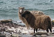
The North Ronaldsay or Orkney is a breed of sheep from North Ronaldsay, the northernmost island of Orkney, off the north coast of Scotland. It belongs to the Northern European short-tailed sheep group of breeds, and has evolved without much cross-breeding with modern breeds. It is a smaller sheep than most, with the rams (males) horned and ewes (females) mostly hornless. It was formerly kept primarily for wool, but now the two largest flocks are feral, one on North Ronaldsay and another on the Orkney island of Auskerry. The Rare Breeds Survival Trust lists the breed as a priority on its 2021–2022 watchlist, and they are in danger of extinction, with fewer than 600 registered breeding females in the United Kingdom.
The semi-feral flock on North Ronaldsay is the original flock that evolved to subsist almost entirely on seaweed – they are one of few mammals to do this. They are confined to the foreshore by a 1.8 m (6 ft) early 19th century drystane dyke, which completely encircles the island, forcing the sheep to evolve this unusual characteristic. The wall was built as kelping (the production of soda ash from seaweed) on the shore became uneconomical. Sheep were confined to the shore to protect the fields and crofts inside, and afterwards subsisted largely on seaweed.
This diet has caused a variety of adaptations in the sheep's digestive system. These sheep have to extract the trace element copper far more efficiently than other breeds as their diet has a limited supply of copper. This results in them being susceptible to copper toxicity, if fed on a grass diet, as copper is toxic to sheep in high quantities. Grazing habits have also changed to suit the sheep's environment. To reduce the chance of being stranded by an incoming tide, they graze at low tide and then ruminate at high tide.
A range of fleece colours are exhibited, including grey, brown and red. Meat from the North Ronaldsay has a distinctive flavour, described as "intense" and "gamey", possibly in part due to the high iodine content in their diet of seaweed. (Full article...)
Selected history & culture article
On 21 June 1919, shortly after the end of the First World War, the Imperial German Navy's High Seas Fleet was scuttled by its sailors while held off the harbour of the British Royal Navy base at Scapa Flow, in the Orkney Islands of Scotland. The fleet was interned there under the terms of the Armistice of 11 November 1918 while negotiations took place over its fate. Fearing that either the British would seize the ships unilaterally or the German government at the time might reject the Treaty of Versailles and resume the war effort (in which case the ships could be used against Germany), Admiral Ludwig von Reuter decided to scuttle the fleet.
Intervening British guard ships were able to beach some of the ships, but 52 of the 74 interned vessels sank. Many of the wrecks were salvaged over the next two decades and were towed away for scrapping. Those that remain are popular diving sites and a source of low-background steel. (Full article...)
Selected island

The Isle of Skye, or simply Skye (/skaɪ/; Scottish Gaelic: An t-Eilean Sgitheanach or Eilean a' Cheò), is the largest and northernmost of the major islands in the Inner Hebrides of Scotland. The island's peninsulas radiate from a mountainous hub dominated by the Cuillin, the rocky slopes of which provide some of the most dramatic mountain scenery in the country. Although Sgitheanach has been suggested to describe a winged shape, no definitive agreement exists as to the name's origins. (Full article...)
Did you know?
- ... that when Norman Heathcote climbed the St Kilda sea stack Stac Lee (pictured) in 1899, he found the climbing "comparatively easy" but getting ashore had been "a most appalling undertaking"?
- ... that the A968 in Shetland is Britain's northernmost A road?
- ...that in the year 1214, the Scot Ruaidhri mac Raghnaill, Lord of Kintyre, stole the treasures of Derry from its monastery?
- ... that a wheelhouse in archaeology is a prehistoric structure from the Iron Age found in Scotland that was neither a wheel, nor perhaps a house?
Selected portrait
Selected geography article
Threave Castle is situated on an island in the River Dee, 2.5 kilometres (1.6 mi) west of Castle Douglas in the historical county of Kirkcudbrightshire in the Dumfries and Galloway region of Scotland.
Built in the 1370s by Archibald the Grim, it was a stronghold of the "Black Douglases", Earls of Douglas and Lords of Galloway, until their fall in 1455. For part of this time, the castle and the lordship of Galloway were controlled by Princess Margaret, daughter of King Robert III and widow of the 4th Earl. In 1449 Threave was regained by the 8th earl, Scotland's most powerful magnate, who controlled extensive lands and numerous castles. He fortified Threave with an "artillery house", a sophisticated defence for its time. The excessive power of the Black Douglas lords led to their overthrow by King James II in 1455, after which Threave was besieged and captured by the King's men.
It became a royal castle, and in the 16th century hereditary responsibility for Threave was given to the Lords Maxwell. It was briefly held by the English in the 1540s, but did not see serious action until the Bishops' Wars, when in 1640 a royalist garrison was besieged by a force of Covenanters. Partially dismantled, the castle remained largely unused until given into state care in 1913. The ruins, comprising the substantially complete tower house and the L-shaped artillery house, are today maintained by Historic Environment Scotland as a scheduled monument.
The castle complex is open to the public. (Full article...)
Selected biography
Magnus III Olafsson (Old Norse: Magnús Óláfsson, Norwegian: Magnus Olavsson; 1073 – 24 August 1103), better known as Magnus Barefoot (Old Norse: Magnús berfœttr, Norwegian: Magnus Berrføtt), was the King of Norway from 1093 until his death in 1103. His reign was marked by aggressive military campaigns and conquest, particularly in the Norse-dominated parts of the British Isles, where he extended his rule to the Kingdom of the Isles and Dublin.
As the only son of King Olaf Kyrre, Magnus was proclaimed king in southeastern Norway shortly after his father's death in 1093. In the north his claim was contested by his cousin, Haakon Magnusson (son of King Magnus Haraldsson), and the two co-ruled uneasily until Haakon's death in 1095. Disgruntled members of the nobility refused to recognise Magnus after his cousin's death, but the insurrection was short-lived. After securing his position domestically, Magnus campaigned around the Irish Sea from 1098 to 1099. He raided through Orkney, the Hebrides and Mann (the Northern and Southern Isles), and ensured Norwegian control by a treaty with the Scottish king. Based on Mann during his time in the west, Magnus had a number of forts and houses built on the island and probably also obtained suzerainty of Galloway. He sailed to Wales later in his expedition, gaining the support of Anglesey (and the Gwynedd) after aiding against the invading Norman forces from the island.
Following his return to Norway, Magnus led campaigns into Dalsland and Västergötland in Sweden, claiming an ancient border with the country. After two unsuccessful invasions and a number of skirmishes Danish king Eric Evergood initiated peace talks among the three Scandinavian monarchs, fearing that the conflict would get out of hand. Magnus concluded peace with the Swedes in 1101 by agreeing to marry Margaret, daughter of the Swedish king Inge Stenkilsson. In return, Magnus gained Dalsland as part of her dowry. He set out on his final western campaign in 1102, and may have sought to conquer Ireland. Magnus entered into an alliance with Irish king Muirchertach Ua Briain of Munster, who recognised Magnus's control of Dublin. Under unclear circumstances, while obtaining food supplies for his return to Norway, Magnus was killed in an ambush by the Ulaid the next year; territorial advances characterising his reign ended with his death.
Into modern times, his legacy has remained more pronounced in Ireland and Scotland than in his native Norway. Among the few domestic developments known during his reign, Norway developed a more centralised rule and moved closer to the European model of church organisation. Popularly portrayed as a Viking warrior rather than a medieval monarch, Magnus was the last Norwegian king to fall in battle abroad, and he may in some respects be considered the final Viking king. (Full article...)
Related portals
Selected panorama
Topics
Categories
The main category is Islands of Scotland, with subcategories

Things you can do
- Add new articles to the project by placing {{WPSI|class=|importance=}} on the talk page
- Add a link to the portal in the "See also" section of relevant articles with {{Portal|Scottish islands}}
- Take requested photographs or create requested pages, including Prehistoric Hebrides, Trialabreac, Dog Isle...
- Expand a Scottish Islands stub into a full article, adding images, citations, references and infoboxes; did you know that if you expand one 5x, you can nominate it for Did You Know?
- Improve one of the highest priority articles, including Mull, Bute, North & South Uist, Columba, Highland Clearances, Sorley MacLean, St Magnus Cathedral...
- Follow these hints to improve a B-class article and nominate it for Good Article

- Suggest articles, pictures, interesting facts, events and news to be featured here on the portal
Wikiproject
Associated Wikimedia
The following Wikimedia Foundation sister projects provide more on this subject:
-
Commons
Free media repository -
Wikibooks
Free textbooks and manuals -
Wikidata
Free knowledge base -
Wikinews
Free-content news -
Wikiquote
Collection of quotations -
Wikisource
Free-content library -
Wikiversity
Free learning tools -
Wikivoyage
Free travel guide -
Wiktionary
Dictionary and thesaurus

