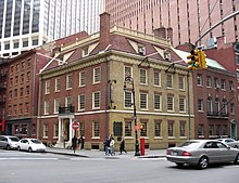
Pearl Street (Manhattan)

Pearl Street is a street in the Lower section of the New York City borough of Manhattan, running northeast from Battery Park to the Brooklyn Bridge, then turning west and terminating at Centre Street. Pearl Street generally marks the original eastern shoreline of the lower part of Manhattan Island; extensive use of landfill over the course of several hundred years has extended the shoreline roughly 700–900 feet further into the East River.
The name Pearl Street is an English translation of the Dutch Parelstraat (written as Paerlstraet around 1660). This street along the eastern shore of New Amsterdam was named for the many oysters found in the river. During the British years, Pearl Street was known as (Great) Queen Street. The "Great" was used often to differentiate from (Little) Queen Street, which in 1784 became Cedar Street.
In the mid 1650s a three storey tavern became NYC's first City Hall near what is now 73 Pearl Street.[1]
Thomas Edison's first power plant, Pearl Street Station, was located here. The IRT Third Avenue elevated railway also ran above Pearl Street until 1950. New York Telephone put up a large administrative building at 375 Pearl on the north side of the Street, east of the Brooklyn Bridge, in the 1970s.
See also
References
External links
40°42′33″N 74°00′07″W / 40.7092°N 74.0019°W
