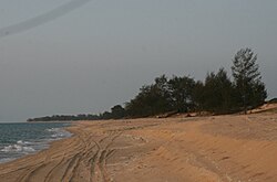
Pennefather River
| Pennefather River | |
|---|---|
 |
The Pennefather River in Queensland, Australia, is located on western Cape York Peninsula at 12°13′S 141°44′E / 12.217°S 141.733°E. The river is about 11 km long and up to about 2 km wide.
The mouth of the river was the site of the first recorded landfall in Australia by a European explorer, by Willem Janszoon in 1606.[1] Janszoon named it R. met het Bosch ("River with the Bush"), so that Australia's first recorded place name intriguingly was named after its iconic bush.[2]
In 1802 Matthew Flinders mistook the river for the Coen River named by Jan Carstensz in 1623 (now the Archer River), so that the Bosch / Pennefather River was named Coen River on maps in the 19th century. In 1880, Captain Charles Edward de Fonblanque Pennefather established that there were now two Coen Rivers,[3] and in 1894 Queensland authorities named the river after him, although the British Admiralty Chart for the Gulf of Carpentaria kept the name Coen River until 1967.[4]
See also
References
- ^ Mutch, T. D. (1942). The First Discovery of Australia. Sydney: Mutch, Project Gutenberg of Australia. p. 31. Retrieved 30 September 2012.
- ^ Jan Tent, Geographic and Linguistic Reflections on Moent and Dubbelde Ree: Two of Australia’s First Recorded Placenames, Geographical Research 44(4):372–385
- ^ The name Coen River eventually was only retained by a southern tributary of the original Coen River.
- ^ Pennefather River at Gutenberg.net.au
External links
- The Part Borne by the Dutch in the Discovery of Australia by J E heeres, 1894
- Placenames Australia, Newsletter of the Australian National Placenames Survey, September 2005
