
Plymouth, Pennsylvania
Plymouth, Pennsylvania | |
|---|---|
Borough | |
 Downtown Plymouth | |
 Location of Plymouth in Luzerne County, Pennsylvania. | |
 Plymouth, Pennsylvania | |
| Coordinates: 41°14′31″N 75°56′53″W / 41.24194°N 75.94806°W | |
| Country | United States |
| State | Pennsylvania |
| County | Luzerne |
| Settled | 1769 |
| Incorporated | 1866 |
| Government | |
| • Type | Borough Council |
| • Mayor | Dorothy Petrosky |
| Area | |
| • Total | 1.18 sq mi (3.07 km2) |
| • Land | 1.10 sq mi (2.84 km2) |
| • Water | 0.09 sq mi (0.22 km2) |
| Population (2010) | |
| • Total | 5,951 |
| • Estimate (2016)[2] | 5,792 |
| • Density | 5,279.85/sq mi (2,037.93/km2) |
| Time zone | UTC−5 (Eastern (EST)) |
| • Summer (DST) | UTC−4 (EDT) |
| Zip code | 18651 |
| Area code | 570 |
| FIPS code | 42-61648 |
Plymouth is an incorporated borough in Luzerne County, Pennsylvania, United States, 4 miles (6 km) west of Wilkes Barre, on the Susquehanna River. Prior to its incorporation in 1866, it was part of Plymouth Township, established in 1769 by the Susquehanna Company and claimed by Connecticut based on the charter of that colony. The Pennamite-Yankee War was fought in the environs.
Plymouth is situated in the rich hard coal fields of Pennsylvania. Coal was first shipped in 1807. In the past, the chief products of its industrial establishments included mining drilling machines, miners' squibs, silk hosiery, and lumber products. In 1890, Plymouth's population was 9,340; its population peaked in 1910 at 16,996. The population was 5,951 at the 2010 census.[3]
Geography
According to the United States Census Bureau, the borough has a total area of 1.2 square miles (3.1 km2), of which 1.1 square miles (2.8 km2) is land and 0.08 square miles (0.2 km2), or 7.31%, is water.[4]
Demographics
| Census | Pop. | Note | %± |
|---|---|---|---|
| 1870 | 2,684 | — | |
| 1880 | 6,065 | 126.0% | |
| 1890 | 9,344 | 54.1% | |
| 1900 | 13,649 | 46.1% | |
| 1910 | 16,996 | 24.5% | |
| 1920 | 16,500 | −2.9% | |
| 1930 | 16,543 | 0.3% | |
| 1940 | 15,507 | −6.3% | |
| 1950 | 13,021 | −16.0% | |
| 1960 | 10,401 | −20.1% | |
| 1970 | 9,536 | −8.3% | |
| 1980 | 7,605 | −20.2% | |
| 1990 | 7,134 | −6.2% | |
| 2000 | 6,507 | −8.8% | |
| 2010 | 5,951 | −8.5% | |
| 2016 (est.) | 5,792 | [2] | −2.7% |
| Sources:[5][6][7][8] | |||
At the 2010 census Plymouth had a population of 5,951. The reported racial and ethnic origin of the population was 90.6% non-Hispanic white, 4.3% African-American, 0.2% Native American, 0.5% Asian, 0.1% non-Hispanic from some other race, 2.0% reporting two or more races and 3.3% Hispanic or Latino.[9]
As of the census[7] of 2000, there were 6,507 people, 2,794 households, and 1,673 families residing in the borough. The population density was 5,924.2 people per square mile (2,284.0/km2). There were 3,260 housing units at an average density of 2,968.0 per square mile (1,144.3/km2). The racial makeup of the borough was 98.43% White, 0.75% African American, 0.15% Native American, 0.11% Asian, 0.22% from other races, and 0.34% from two or more races. Hispanic or Latino of any race were 0.80% of the population.
There were 2,794 households, out of which 26.8% had children under the age of 18 living with them, 40.6% were married couples living together, 14.6% had a female householder with no husband present, and 40.1% were non-families. 35.5% of all households were made up of individuals, and 20.9% had someone living alone who was 65 years of age or older. The average household size was 2.31 and the average family size was 3.02.
In the borough the population was spread out, with 23.2% under the age of 18, 8.5% from 18 to 24, 26.9% from 25 to 44, 20.7% from 45 to 64, and 20.7% who were 65 years of age or older. The median age was 39 years. For every 100 females there were 86.2 males. For every 100 females age 18 and over, there were 82.2 males.
The median income for a household in the borough was $27,379, and the median income for a family was $36,060. Males had a median income of $26,111 versus $20,429 for females. The per capita income for the borough was $14,207. About 10.8% of families and 15.2% of the population were below the poverty line, including 25.2% of those under age 18 and 13.4% of those age 65 or over.
History of Plymouth (1753–1972)
Coal mining in Plymouth
Buildings of Plymouth
Notable people
Among the noteworthy individuals who claimed Plymouth as their birthplace or former residence, and then gained a measure of fame beyond the town's borders were:
- Abe Cohen
- Stanley Woodward Davenport
- Harry Livingston French
- Arthur Horace James
- Col. Benjamin Washington Johnson
- Joe Katchik
- David Kautter
- John E. Mazur
- John G. Mellus
- Frank Comerford Walker
- Gwilym Gwent aka William Aubrey Williams
- Hendrick Bradley Wright
Gallery of Plymouth Maps
-
 Detail of 1858 Anthracite Map
 -
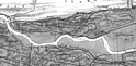
 Detail of 1864 David Schooley Luzerne County Map
 -
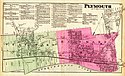 1873 Beers Map of Plymouth, Pennsylvania
 -
 1884 Aerial View of Plymouth
 -
 1884 PA State Mine Map of Plymouth


References
- ^ "2016 U.S. Gazetteer Files". United States Census Bureau. Retrieved Aug 14, 2017.
- ^ a b "Population and Housing Unit Estimates". Retrieved June 9, 2017.
- ^ "Profile of General Population and Housing Characteristics: 2010 Demographic Profile Data (DP-1): Plymouth borough, Pennsylvania". U.S. Census Bureau, American Factfinder. Retrieved April 12, 2012.
- ^ "Geographic Identifiers: 2010 Demographic Profile Data (G001): Plymouth borough, Pennsylvania". U.S. Census Bureau, American Factfinder. Retrieved April 12, 2012.
- ^ "Number of Inhabitants: Pennsylvania" (PDF). 18th Census of the United States. U.S. Census Bureau. Retrieved 22 November 2013.
- ^ "Pennsylvania: Population and Housing Unit Counts" (PDF). U.S. Census Bureau. Retrieved 22 November 2013.
- ^ a b "American FactFinder". United States Census Bureau. Retrieved 2008-01-31.
- ^ "Incorporated Places and Minor Civil Divisions Datasets: Subcounty Population Estimates: April 1, 2010 to July 1, 2012". U.S. Census Bureau. Retrieved 25 November 2013.
- ^ 2010 census report on Plymouth, Pennsylvania
External links
![]() Media related to Plymouth, Pennsylvania at Wikimedia Commons
Media related to Plymouth, Pennsylvania at Wikimedia Commons
