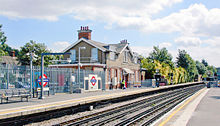
South Harrow tube station
| South Harrow | |
|---|---|
 Southern entrance | |
| Location | South Harrow |
| Local authority | London Borough of Harrow |
| Managed by | London Underground |
| Number of platforms | 2 |
| Fare zone | 5 |
| London Underground annual entry and exit | |
| 2019 | |
| 2020 | |
| 2021 | |
| 2022 | |
| 2023 | |
| Key dates | |
| 1903 | Opened as terminus (DR) |
| 1910 | Becomes through station |
| 1932 | Start (Piccadilly line, terminus) |
| 1932 | End (District line, eastbound) |
| 1933 | Start (Piccadilly line to Uxbridge) |
| 1932 | End (District line) |
| 3 April 1954 | Goods yard closed[6] |
| Other information | |
| External links | |

South Harrow is a London Underground station on the Uxbridge branch of the Piccadilly line. The station is between Sudbury Hill and Rayners Lane. It is located on Northolt Road (A312). The station is in Travelcard Zone 5. There are several bus stands outside the station as well as overnight train stabling sidings.
History
South Harrow station was opened on 28 June 1903 by the District Railway (DR, now the District line) as the terminus of its new extension from Park Royal & Twyford Abbey.[7]
This new extension was, together with the existing tracks back to Acton Town, the first section of the Underground's surface lines to be electrified and operate electric instead of steam trains.[8] The Deep level tube lines open at that time (City & South London Railway, Waterloo & City Railway and Central London Railway) had been electrically powered from the start.
On 1 March 1910, the DR was extended north to meet the Metropolitan Railway (MR, now the Metropolitan line) tracks at Rayners Lane and services commenced over the MR's tracks to Uxbridge.[7] North of the station the line crosses the Roxeth Marsh; the viaduct over it between South Harrow and Rayners Lane was an engineering feat of the time.
On 4 July 1932, the Piccadilly line was extended to run west of its original terminus at Hammersmith sharing the route with the District line to Ealing Common.[7] From Ealing Common to South Harrow, the District line was replaced by the Piccadilly line. From South Harrow north, an isolated District line service continued to operate to Uxbridge until 22 October 1933 when the Piccadilly line took over the service to Uxbridge.[7]
The original station building is located approximately 170m south of the existing station and can be accessed from South Hill Avenue. It is similar to the building still in use at North Ealing and remains, adjacent to the eastbound platform, in the car park on the north side of the tracks.Today it is used by London Underground as office space for drivers before and after stabling trains in the sidings and driver shift changes. On 5 July 1935, a new station was opened accessed from Northolt Road.[7] The new station building was designed by Charles Holden as a graduated structure stepping up on each side to the platforms of the high level tracks. The brick walls and bands of horizontal glazing are capped with a series of flat concrete slab roofs.
Stabling Sidings
The 5 west facing dead ended sidings are located to the east of South Harrow and are accessed from both platforms via a crossover. They are mainly used to stable trains at the close of service.
Services
The typical off-peak service is a train in each direction every ten minutes. Half of northbound trains terminate at Rayners Lane tube station and the other half continue to the terminus of the line at Uxbridge.
Connections
London Buses routes 114, 140, 258, 395, 398, 487, H9, H10 and H12 serve the station.
References
- ^ "Station Usage Data" (XLSX). Usage Statistics for London Stations, 2019. Transport for London. 23 September 2020. Archived from the original on 9 November 2020. Retrieved 9 November 2020.
- ^ "Station Usage Data" (XLSX). Usage Statistics for London Stations, 2020. Transport for London. 16 April 2021. Retrieved 1 January 2022.
- ^ "Station Usage Data" (XLSX). Usage Statistics for London Stations, 2021. Transport for London. 12 July 2022. Retrieved 7 September 2022.
- ^ "Station Usage Data" (XLSX). Usage Statistics for London Stations, 2022. Transport for London. 4 October 2023. Retrieved 10 October 2023.
- ^ "Station Usage Data" (XLSX). Usage Statistics for London Stations, 2023. Transport for London. 8 August 2024. Retrieved 16 September 2024.
- ^ Hardy, Brian, ed. (March 2011). "How it used to be - freight on The Underground 50 years ago". Underground News (591). London Underground Railway Society: 175–183. ISSN 0306-8617.
- ^ a b c d e Rose, Douglas (1999). The London Underground, A Diagrammatic History. Douglas Rose/Capital Transport. ISBN 1-85414-219-4.
- ^ "District Line, Dates". Clive's Underground Line Guides. Archived from the original on 10 January 2014.
{{cite web}}: Unknown parameter|deadurl=ignored (|url-status=suggested) (help)
External links
- "South Harrow station, 1913". Harrow Borough Council. Archived from the original on 27 March 2005.
{{cite web}}: Unknown parameter|deadurl=ignored (|url-status=suggested) (help) - "South Harrow". Photographic Archive. London Transport Museum. Archived from the original on 11 February 2014.
{{cite web}}: Unknown parameter|deadurl=ignored (|url-status=suggested) (help)- South Harrow station, 1926. A children's outting is leaving the station.
- Booking hall, 1928
- View along platforms, 1932
- New station, 1935
- Booking hall, 1935
- Booking hall, 1958. Looking towards entrance
- Use dmy dates from August 2012
- Rail transport stations in London fare zone 5
- Piccadilly line stations
- Tube stations in Harrow
- Former London Electric Railway stations
- Former Metropolitan District Railway stations
- Railway stations opened in 1903
- Railway stations closed in 1935
- Railway stations opened in 1935
- Charles Holden buildings
