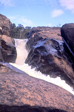
Tully Falls
Appearance
| Tully Falls | |
|---|---|
 Tully Falls, in 1959 | |
 | |
| Location | Far North Queensland, Australia |
| Type | Horsetail chute |
| Elevation | 673 metres (2,208 ft) AHD[3] |
| Total height | 180–210 metres (590–690 ft)[4] |
| Number of drops | 1 |
| Watercourse | Tully River |
The Tully Falls, a horsetail chute waterfall on the Tully River, is located in the UNESCO World Heritage–listed Wet Tropics in the Far North region of Queensland, Australia.
Location and features
From the Atherton Tableland at an approximate elevation of 673 metres (2,208 ft)[3] above sea level, the falls descend in the range of 180–210 metres (590–690 ft)[4] into the Tully Gorge National Park, near the town of Ravenshoe. Access to the falls is via a 1.6-kilometre (0.99 mi) graded track.[5]
Most of the water that would have otherwise flowed over the falls has been diverted to the Kareeya Hydro Power Station and dammed by Koombooloomba Dam. As a result, the falls flow only during a big wet season.[5]
See also
References
- ^ "Tully Falls (QLD)". Gazetteer of Australia online. Geoscience Australia, Australian Government.
- ^ "Tully Falls (entry 35300)". Queensland Place Names. Queensland Government. Retrieved 13 September 2015.
- ^ a b "Map of Tully Falls, QLD (the town)". Bonzle Digital Atlas of Australia. Retrieved 30 May 2014.
- ^ a b "Tully Falls". World Waterfall Database. 21 May 2011. Retrieved 30 May 2014.
- ^ a b "Things to Do Tully Falls". Wet Tropics Management Authority. Retrieved 29 January 2008.

