
User:Messechkova/sandbox

This article needs additional citations for verification. (March 2010) |
Vík í Mýrdal | |
|---|---|
Town | |
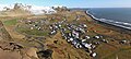
 Vík í Mýrdal from above | |
 Location of the Municipality of Mýrdalshreppur | |
 Vík í Mýrdal Location in Iceland | |
| Coordinates: 63°25′N 19°00′W / 63.417°N 19.000°W | |
| Country | Iceland |
| Constituency[1] | South Constituency |
| Region[2] | Southern Region |
| Municipality | Mýrdalshreppur |
| Population (2011) | |
| • Total | 291 |
| Time zone | UTC+0 (GMT) |
The village of Vík (ⓘ; or Vík í Mýrdal in full) is the southernmost village in Iceland, located on the main ring road around the island, around 180 km (110 mi) by road southeast of Reykjavík.
Despite its small size (291 inhabitants as of January 2011) it is the largest settlement for some 70 km (43 mi) around and is an important staging post, thus it is indicated on road signs from a long distance away. It is an important service center for the inhabitants and visitors to the coastal strip between Skógar and the west edge of the Mýrdalssandur glacial outwash plain.
Overview[edit]
In 1991, the US journal Islands Magazine counted this beach as one of the ten most beautiful beaches on Earth. Its stretch of black basalt sand is one of the wettest places in Iceland. The cliffs west of the beach are home to many seabirds, most notably puffins which burrow into the shallow soils during the nesting season. Offshore lie fingers of basalt rock (stacks) remnants of a once more extensive cliffline Reynisfjall, now battered by the sea. There is no landmass between here and Antarctica and the Atlantic rollers can attack with full force. Folklore tells us that they are former trolls who tried to drag their boats out to sea only to be caught by the rising dawn. The sea around them is rather wild and stormy, so travelers will not be surprised to discover a monument to the memory of drowned seamen on the beach.


The village was affected by volcanic ash during the 2010 eruptions of Eyjafjallajökull.[3][4][5]
Danger from Katla[edit]
Vík lies directly beneath the Mýrdalsjökull glacier, which itself is on top of the Katla volcano. Katla has not erupted since 1918, and this longer than typical repose period has led to speculation that an eruption may occur soon. An eruption of Katla could melt enough ice to trigger an enormous flash flood, potentially large enough to obliterate the entire town. The town's church, located high on a hill, is believed to be the only building that would survive such a flood.[6] Thus, the people of Vík practice periodic drills and are trained to rush to the church at the first sign of an eruption.[citation needed]
Climate[edit]
Like most of coastal Iceland, Vík í Mýrdal has a subpolar oceanic climate (Koppen: Cfc) with cold but not severe winters and cool, short summers. Because it lies on the windward side of the Gulf Stream, Vík í Mýrdal is the wettest coastal town in Iceland, with an annual rainfall of 2,275 millimetres (90 in), which is three times more than Reykjavík, five times more than Akureyri on the north coast of the island and many times more than its far northernly location would normally indicate. Precipitation on the Mýrdalsjökull and Vatnajökull glaciers near the town is believed to be as high as 160 inches (4,100 mm) of rainfall equivalent, which would mean at least 160 feet (49 m) of snow at those higher altitudes.
| Climate data for Vík í Mýrdal | |||||||||||||
|---|---|---|---|---|---|---|---|---|---|---|---|---|---|
| Month | Jan | Feb | Mar | Apr | May | Jun | Jul | Aug | Sep | Oct | Nov | Dec | Year |
| Record high °C (°F) | 9.4 (48.9) |
11.1 (52.0) |
9.4 (48.9) |
13.9 (57.0) |
16.1 (61.0) |
25.0 (77.0) |
27.7 (81.9) |
30.3 (86.5) |
16.1 (61.0) |
12.8 (55.0) |
10.6 (51.1) |
10.0 (50.0) |
30.3 (86.5) |
| Mean daily maximum °C (°F) | 3.3 (37.9) |
3.9 (39.0) |
5.6 (42.1) |
7.5 (45.5) |
10.0 (50.0) |
12.2 (54.0) |
14.4 (57.9) |
13.9 (57.0) |
11.1 (52.0) |
7.2 (45.0) |
5.0 (41.0) |
4.4 (39.9) |
8.1 (46.6) |
| Daily mean °C (°F) | 1.1 (34.0) |
1.4 (34.5) |
2.8 (37.0) |
4.5 (40.1) |
7.5 (45.5) |
9.5 (49.1) |
11.9 (53.4) |
11.4 (52.5) |
8.9 (48.0) |
5.0 (41.0) |
2.8 (37.0) |
2.5 (36.5) |
5.8 (42.4) |
| Mean daily minimum °C (°F) | −1.1 (30.0) |
−1.1 (30.0) |
0.0 (32.0) |
2.2 (36.0) |
5.0 (41.0) |
6.7 (44.1) |
9.4 (48.9) |
8.9 (48.0) |
6.7 (44.1) |
2.8 (37.0) |
0.6 (33.1) |
0.6 (33.1) |
3.4 (38.1) |
| Record low °C (°F) | −10.6 (12.9) |
−12.3 (9.9) |
−10.6 (12.9) |
−6.1 (21.0) |
−3.9 (25.0) |
−0.6 (30.9) |
3.9 (39.0) |
3.9 (39.0) |
0.6 (33.1) |
−5.6 (21.9) |
−7.8 (18.0) |
−6.7 (19.9) |
−12.3 (9.9) |
| Average precipitation mm (inches) | 182.9 (7.20) |
160.0 (6.30) |
165.1 (6.50) |
170.2 (6.70) |
137.2 (5.40) |
160.0 (6.30) |
177.8 (7.00) |
203.2 (8.00) |
243.8 (9.60) |
233.7 (9.20) |
205.7 (8.10) |
233.7 (9.20) |
2,273.3 (89.5) |
| Source: Sistema de Clasificación Bioclimática Mundial [7] | |||||||||||||
Landscape[edit]
The area around Vík í Mýrdal.[8] has a varied landscape typical for South Iceland. Some of the most popular sights are the Black Sand Beach, Reynisfjall with its basalt-lava rock formations and sea-made caves. Pétursey, Hjörleifshöfði with its historical palagonite mountains and Hafursey tower over the black expanse that surrounds them. In the furthest west point of the district is Mýrdalsjökull, Sólheimajökull. The Jökulsá river on Sólheimasandur has its origin from the hot springs beneath this glacier. It has a strong smell from the sulphuric hydrogen sulphide that its water contains which has led to it being named "Fúlilækur" (Smelly River). Between Höfðabrekkuafrétti and Mýrdalssandur you'll find Thakgil ("Þakgil") - "þak" meaning roof and "gil" meaning canyon.
Tourism[edit]
Gallery[edit]
-
 Vík í Mýrdal from above
 -
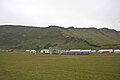
 Wool factory
 -
 Reynisdrangar – sea stacks
 -
 Vik Football Club
 -
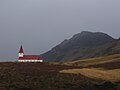 Vík church
 -
 Village of Vík
 -
 Black sand beach


See also[edit]
References[edit]
- ^ Political division
- ^ Mainly statistical division
- ^ "Volcanic ash covers Icelandic town". BBC News. 2010-05-08.
- ^ CBS News http://www.cbsnews.com/2100-202_162-20119947.html.
{{cite news}}: Missing or empty|title=(help) - ^ http://www.washingtontimes.com/news/2010/mar/21/volcano-erupts-southern-iceland/?page=all
- ^ "Threat of new, larger Icelandic eruption looms". yahoo.com. Yahoo Inc. Retrieved 2010-04-26. [dead link]
- ^ "ICELAND - VIK". Centro de Investigaciones Fitosociológicas. Retrieved 2011-09-17.
- ^ "Visit South Iceland". www.south.is. South Iceland Ltd.
External links[edit]

63°25′10″N 19°00′35″W / 63.41944°N 19.00972°W
Category:Populated places in Southern Region (Iceland)