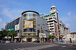
Zhonglou, Changzhou
Zhonglou
钟楼区 | |
|---|---|
 Clock tower located near Qingguo Lane | |
| Coordinates: 31°47′41″N 119°54′32″E / 31.7948°N 119.9090°E | |
| Country | People's Republic of China |
| Province | Jiangsu |
| Prefecture-level city | Changzhou |
| Area | |
• District | 133 km2 (51 sq mi) |
| Population (2020) | |
• District | 658,537 |
| • Density | 5,000/km2 (13,000/sq mi) |
| • Urban | 615,112 |
| Time zone | UTC+8 (China Standard) |
| Postal code | 213000 |
Zhonglou District (simplified Chinese: 钟楼区; traditional Chinese: 鐘樓區; pinyin: Zhōnglóu Qū; lit. 'Clock tower') is one of five districts under the jurisdiction of Changzhou in Jiangsu province of the People's Republic of China. The local language is the Changzhou dialect of Wu Chinese. The postal code for the district is 213002. Zhonglou covers an area of 71 square kilometers. In 2020 the total population was recorded at 658,537 people.[1]
It is also the location of the Nan Da Jie shopping mall (Chinese: 南大街; pinyin: Nán Dà Jiē; lit. 'South Avenue'), one of the unofficial centers of the city. Nan Da Jie is home to many restaurants and chain stores as well as a number of educational companies and apartment complexes.
The district takes its name from a large belfry that once stood in the area.[2]
Administrative divisions
[edit]At present, Zhonglou District has 7 subdistricts.[3]
- 7 subdistricts
References
[edit]- ^ "Zhōnglóu Qū (District, China) - Population Statistics, Charts, Map and Location". www.citypopulation.de. Retrieved 2024-11-20.
- ^ 走进钟楼 Archived September 19, 2008, at the Wayback Machine
- ^ "常州市-行政区划网 www.xzqh.org" (in Chinese). XZQH. Retrieved 2012-05-24.
External links
[edit]

