Beaurains
Beaurains | |
|---|---|
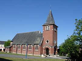
 The church of Beaurains | |
| Coordinates: 50°15′50″N 2°47′22″E / 50.2639°N 2.7894°E | |
| Country | France |
| Region | Hauts-de-France |
| Department | Pas-de-Calais |
| Arrondissement | Arras |
| Canton | Arras-3 |
| Intercommunality | CU d'Arras |
| Government | |
| • Mayor (2020–2026) | Pierre Ansart[1] |
| Area 1 | 5.99 km2 (2.31 sq mi) |
| Population (2021)[2] | 5,515 |
| • Density | 920/km2 (2,400/sq mi) |
| Time zone | UTC+01:00 (CET) |
| • Summer (DST) | UTC+02:00 (CEST) |
| INSEE/Postal code | 62099 /62217 |
| Elevation | 70–99 m (230–325 ft) (avg. 92 m or 302 ft) |
| 1 French Land Register data, which excludes lakes, ponds, glaciers > 1 km2 (0.386 sq mi or 247 acres) and river estuaries. | |
Beaurains (French pronunciation: [boʁɛ̃]) is a commune in the Pas-de-Calais department in the Hauts-de-France region in northern France.[3]
Geography
A suburban town located 3 miles (5 km) south of Arras at the junction of the N17 with the D5 road.
History

The first church here was built in 674. In the 12th century, the parish council created an important leprosarium that treated Jean Bodel, a French poet.
On 21 December 1922, a large treasure was discovered dating from the Roman era. Known as the Beaurains Treasure, much was squandered and the little that remains is now at Arras. However, a silver candelabra, gold coins and some jewellery from the treasure are also in the British Museum.[4]
The commune was all but destroyed during World War I.
The 19th-century French playwright and librettist Armand d'Artois was born in the village on 3 Octobre 1788
Population
| Year | Pop. | ±% p.a. |
|---|---|---|
| 1968 | 2,012 | — |
| 1975 | 3,982 | +10.24% |
| 1982 | 3,922 | −0.22% |
| 1990 | 4,379 | +1.39% |
| 1999 | 4,708 | +0.81% |
| 2007 | 5,066 | +0.92% |
| 2012 | 5,259 | +0.75% |
| 2017 | 5,662 | +1.49% |
| Source: INSEE[5] | ||
Sights
- The church of St. Martin, rebuilt after 1918, along with the rest of the village.
- Vestiges of an old castle.
- Two World War I cemeteries.
See also
References
- ^ "Répertoire national des élus: les maires". data.gouv.fr, Plateforme ouverte des données publiques françaises (in French). 2 December 2020.
- ^ "Populations légales 2021" (in French). The National Institute of Statistics and Economic Studies. 28 December 2023.
- ^ INSEE commune file
- ^ British Museum Collection
- ^ Population en historique depuis 1968, INSEE
External links
- Official website of Beaurains (in French)
- The CWGC cemetery at Beaurains
- communal cemetery at Beaurains


