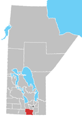
Rural Municipality of Roland
Rural Municipality of Roland | |
|---|---|
Location of Rural Municipality of Roland in Manitoba | |
| Coordinates: 49°21′17″N 97°53′59″W / 49.35472°N 97.89972°W | |
| Country | Canada |
| Province | Manitoba |
| Area | |
| • Land | 485.21 km2 (187.34 sq mi) |
| Population | |
| • Total | 1,129 |
| Time zone | UTC-6 (CST) |
| • Summer (DST) | UTC-5 (CDT) |
| Area codes | 204 and 431 |
Roland is a rural municipality located in the Pembina Valley Region of Manitoba, Canada. According to the Canada 2016 Census, it has a population of 1,129.
Communities
- Graham
- Jordan
- Kronsgart
- Myrtle
- Roland
Demographics
In the 2021 Census of Population conducted by Statistics Canada, Roland had a population of 1,145 living in 393 of its 424 total private dwellings, a change of 1.4% from its 2016 population of 1,129. With a land area of 484.47 km2 (187.05 sq mi), it had a population density of 2.4/km2 (6.1/sq mi) in 2021.[2]
Notable people
External links
References
- ^ a b "Population and dwelling counts, for Canada, provinces and territories, and census subdivisions (municipalities), 2016 and 2011 censuses – 100% data (Manitoba)". Statistics Canada. February 7, 2018. Retrieved January 15, 2022.
- ^ "Population and dwelling counts: Canada, provinces and territories, and census subdivisions (municipalities), Manitoba". Statistics Canada. February 9, 2022. Retrieved February 20, 2022.
- ^ Mowbray, G. E. (June 1, 1911), 1911 Canadian Census, Lisgar, Manitoba: Government of Canada, p. 24
- Manitoba Historical Society - Rural Municipality of Roland
- Roland RM, MB Community Profile
- Map of Roland R.M. at Statcan


