
Tasmanian Wilderness World Heritage Area
| UNESCO World Heritage Site | |
|---|---|
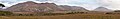
 Lake Judd from Mount Eliza, Southwest National Park | |
| Location | Tasmania, Australia |
| Criteria | Cultural: iii, iv, vi, vii; natural: viii, ix, x |
| Reference | 181 |
| Inscription | 1982 (6th Session) |
| Extensions | 1989 |
| Area | 1,584,233 ha (3,914,720 acres) |
| Coordinates | 42°35′45″S 146°10′22″E / 42.5957°S 146.1729°E |
 Tasmanian Wilderness World Heritage Area
 | |
The Tasmanian Wilderness World Heritage Area, abbreviated to TWWHA, is a World Heritage Site in Tasmania, Australia.[1][2] It is one of the largest conservation areas in Australia, covering 15,800 km2 (6,100 sq mi), or almost 25 per cent of Tasmania. It is also one of the last expanses of temperate wilderness in the world, and includes the South West Wilderness.
The main industry of the TWWHA is tourism, yet the region has a lack of development partially due to the juxtaposition of development with the idea of pristine nature. There is no permanent habitation in the area save for small parts on the periphery. The region is known for activities such as bushwalking, whitewater rafting, and climbing.
The Tasmanian Wilderness qualifies for 7 out of the 10 classification criteria evaluated for World Heritage. Along with Mount Tai in China, it is the highest measurement attained for World Heritage Site status on Earth.[3]
The TWWHA was first placed on the World Heritage List in 1982 under joint arrangements between the federal government of Australia and the Tasmanian government during the Franklin Dam controversy, and expanded in 1989 following the Helsham Inquiry, a decision to protect a eucalypt forest from logging. Due to the subpar planning and management of the area during the 1990s, a management plan was drawn up and promulgated in 1992, further replaced by a new management plan in 1999. In 2014, the Abbott government proposed de-listing the Tasmanian Wilderness as a World Heritage Site so as to allow the logging of trees within the protected area. This was rejected by the World Heritage Committee the same year. In 2016, the Tasmanian government withdrew the bid to allow logging in the Tasmanian Wilderness after a UNESCO report opposed the idea.
Background[edit]
Tasmania is one of the states of Australia. It is an island in the Southern Ocean, immediately south of mainland Australia. It has a temperate maritime climate, substantially different from most of mainland Australia.[4]: 7 Australia has 13 World Heritage Areas, the first of which was listed in 1981.[5]: 192 The best known are Kakadu, Uluru (formerly known as Ayers Rock) and the Great Barrier Reef. The Tasmanian Wilderness is probably the best known of the rest.[6]
Tasmania is approximately 296 km (184 mi) north to south and 315 km (196 mi) east to west,[7]: 6 and about 300 km (190 mi) south of mainland Australia. Around 30 per cent of the state's land is reserved under some category of conservation land tenure. The Tasmanian Wilderness covers approximately 20 per cent of the state. It comprises Tasmania's four largest national parks and several smaller areas of various other conservation land tenures. 3.4 million hectares out of the 6.8 million hectares of Tasmanian land is covered by forest, 70 per cent of which is in public land, 40 per cent in commercial forests, and 30 per cent on protected public land.[8]: 38 Tasmania has a population just under 500,000. It has the weakest economy of all the Australian states, and tourism is seen as one of the few economic growth areas. Tasmania's tourism marketing promotes ecotourism based on the state's natural values; particularly those of the Tasmanian Wilderness. This puts considerable environmental pressure on the Tasmanian Wilderness even though most tourist accommodation is outside the boundaries and most tourism occurs at a few well-developed sites near the periphery of the area.[6]
Geography[edit]
The Tasmanian Wilderness is an extensive, wet, temperate, wilderness area covering much of southern and western Tasmania. It is approximately 200 km (120 mi) north to south and averages 70 km (43 mi) east to west, or 1.38 million ha (3.4 million acres) before expansions in 2013.[9]: 229 The area of the region became 15,800 kilometres2, or almost 25% of Tasmania after extensions in 1989 and 2013.[10][11] Although the highest point is only 1,600 metres (5,000 feet) above sea level and there is no year-round snow cover, much of the area is very rugged and contains the only extensive, recently glaciated areas in Australia. The last glaciation ended 10,000 to 12,000 years ago.[6] It constitutes one of the last expanses of temperate wilderness in the world, and includes the South West Wilderness.[12][13]
Development and tourism[edit]
The Tasmanian Wilderness contains no permanent human habitation, apart from a small amount of accommodation near the periphery. Few roads penetrate the area.[14]: 2 There is also a trout fishery (introduced northern hemisphere species) in the Central Plateau lakes. Unlike most of the rest of the Tasmanian Wilderness, the Central Plateau section has a long history of use by local people. As well as fishing, some hunting, horse riding, four-wheel-driving and associated hut use continues. These established practices are seen by some groups to be at odds with achieving conservation outcomes.[6] This has led to the removal of roads, huts, and any other human traces in favor of the idea of a pristine wilderness.[15]: 112
Tourism and recreation is the predominant industry in the area.[6] There are about half a million visitors to the TWWHA annually. Activities within the TWWHA include cruises, commercial flights and landings,[16]: 431 bushwalking (it has been described as the Mecca of bushwalkers in Australia),[6] whitewater rafting, and climbing.[16]: 431 More remote regions of the TWWHA have no ports, and thus expedition ships are used for land-based activities.[14]: 2 However, due to management guidelines in the TWWHA, the region remains rarely visited by these ships, though there are also smaller commercial ships in the area.[17]: 475
Biology[edit]
Flora[edit]


The TWWHA is located in the Australasian realm. One of the supporting factors for its listing as a World Heritage Site is its biodiversity and natural qualities. There are six ecosystem groups in the TWWHA - rainforest, sclerophyll communities, alpine treeless vegetation, subalpine treeless vegetation, and wetland communities. The TWWHA includes many species of ancient origin, primitive taxa, and a high degree of plant diversity, with unusual features such as scleromorphic shrubs evolving in a maritime climate in alpine and subalpine treeless ecosystems. The TWWHA also contains the longest continuous pollen record in Australia at the Darwin Crater.[19]: 5–16
Fauna[edit]
The TWWHA includes 1,397 species from 293 families.[20] There are 30 species of terrestrial mammals, 120 species of terrestrial birds, 14 species of terrestrial reptiles, seven species of frogs, 16 species of freshwater fish, and 68 species of marine fish. Much of the fauna found within the TWWHA is unique to the area, such as the Moss Froglet and the Pedra Branca Skink.[21] In terms of invertebrates, the TWWHA includes 904 species of Uniramia, 179 species of Chelicerata, 90 species of Aschelminthes, 88 species of Crustacea, 69 species of Mollusca, 57 species of Annelida, eight species of Platyhelminthes, and one species each for Onychophora and Nemertea.[20]
History[edit]
Pre 20th century[edit]

.jpg)
The Tasmanian Wilderness, a network of parks and reserves with steep gorges, underwent severe glaciation. Human remains dating back more than 20,000 years have been found in limestone caves in the area.[22] The area was used for millennia by Aboriginals, who have left their signature on the area in the form of an ecology strongly influenced by their burning practices, as well as physical remains including middens and artwork. The aboriginal presence in the area dates back to the Pleistocene, 35,000 years ago.[14]: 3 Middens from the Holocene have been found in the area.[23]: 126 No Aboriginals now live permanently in the area,[6] but some places are of great significance to the present-day Tasmanian Aboriginal Community, which influenced the region's listing as a World Heritage Site.[24]: 357 Historically, the area was extensively explored and prospected during the 19th century, with a history of convicts in the area,[23]: 126 but the only economic activity in the area has been small-scale mining and logging, a limited amount of trapping (for furs) and, in a limited area, grazing, which continued until very recently. The area also contains one large and several smaller hydroelectric schemes. Apart from the hydroelectric impoundments, none of these activities have left much lasting trace.[6]
World heritage status[edit]
1980s[edit]
The area was placed on the World Heritage List in two stages, in 1982 and 1989. The 1982 listing came in the midst of a political furore over the proposed construction of a major hydroelectric dam within the area. Construction of the dam did not proceed as a result of federal government intervention using authority obtained as a result of the World Heritage listing.[9]: 229–30 [6] The factors influencing its listing include the aboriginal heritage of the site, geomorphic values, and biodiversity.[24]: 357
The area was expanded in 1989 as a result of the Helsham Inquiry, a decision to protect a major area of tall eucalypt forest from logging. This began a conflict regarding further inclusion of areas - the majority opinion stated that only five areas deserved to be listed, while the differing view was that there were additional areas to those five, ending up in an additional 600,000 hectares.[23]: 126 The latter of these views later prevailed, ending in the expansion of the area greatly.[25]: 49 In the same year, the region was given a statutory management plan.[9]: 231 Again, the area's World Heritage status gave the federal government the right to be involved, and reinforced the perception in some sections of the Tasmanian community that World Heritage listing was a ploy to give the federal government the right to intervene in land management issues which would otherwise be a matter for the state government alone.[6]

During the 1980s, the funding of the management of the area was greatly increased from around 1 million Australian dollars in the early 1980s to 3 million by the middle of the decade. In the mid-1990s, funding reached 9 million dollars, while the budget reached 11 million in 2008. This increase in funding importantly allowed for the employment of more staff.[9]: 230–31
There was also serious distrust of the Parks and Wildlife Service in some quarters, mostly dating back to when the Central Plateau was added to the Tasmanian Wilderness in 1989. Many established practitioners had been led to believe that all activities that had previously been permitted within the area would be allowed to continue after World Heritage listing. Soon after listing, some of their more environmentally unacceptable activities were restricted or banned to reflect the new status of the area (for example, several four-wheel-drive tracks into sensitive areas were closed). This resulted in a polarisation of strongly held views in the Tasmanian community on the future management of the area and, in some quarters, considerable antagonism towards the Parks and Wildlife Service.[6] Many people in the local communities were affected by the little consideration they got from "Wilderness ideology", leading to their acting against good management practices due to their mistrust of the Parks and Wildlife Service.[23]: 131
1990s[edit]
In 1990, planning for the area was still poorly coordinated. Only one of the four major national parks had a finalised management plan and, although plans were in varying stages of completion for several other parts of the Tasmanian Wilderness, the decision was made to prepare a single management plan for the entire area. Several stages of public comment, accompanied at times by considerable controversy in the local media, led to a very "pro-wilderness" draft management plan. A series of last-minute alterations to the plan, following a change of state government and after the closure of public comment, diluted the "pro-wilderness" nature of the plan and thereby antagonised the conservation lobby, but defused many of the strongly felt objections of established users, some of whom had threatened civil disobedience in relation to some plan prescriptions. However, some of these stakeholders, particularly local communities adjacent to the area, felt that their input to the planning process had been ignored and remained fundamentally dissatisfied with aspects of the plan, which was finalised in September 1992. Some aspects of the 1992 plan met with poor acceptance from "established practitioners" from the start, and some other problems (such as the absence of a mechanism to assess new development proposals) became apparent as the plan was implemented. Nevertheless, it guided management of the area for the next seven years, two years longer than its intended life.[6]
The 1992 plan helped develop a framework by which to gauge the effectiveness of management plans. Under Dr. Helen Hocking, the achievement of the plan's objectives was evaluated.[28]: 72 The plan was criticized as treating "wilderness" as the most important value of the region and disregarding all other values[29]: 368 The Parks and Wildlife Service was determined to overcome a number of the ongoing issues identified from the 1992 plan so, in 1994, the decision was made to review the plan with the aim of having the new plan in place by September 1997. This deadline was not met for a variety of reasons, including state and federal elections that delayed key approval processes. The new plan took effect in March 1999. The most controversial management issues dealt with in the development of the new plan were those related to tourism, established practices and fire management; the key nature conservation question being whether land managers should actively use fire to maintain the diversity of the ecosystem.[6] The plan also added into consideration Aboriginal cultural heritage and tourism.[29]: 368
21st century[edit]

In September 2004, the first State of the Tasmanian Wilderness World Heritage Area Report was released, which focused on ecological protection.[31]
Despite advising the UN World Heritage Committee (WHC) in 2010 that it had no intention to extend the property any further,[32] the federal government submitted a proposal for a minor boundary modification to the property in January 2013 which was accepted at the 37th session of the WHC in June 2013.[33]
In 2014, the Abbott government proposed de-listing the Tasmanian Wilderness as a World Heritage Site so as to allow the logging of trees within the protected area.[30] If successful, the proposal would have marked the first time a developed nation had de-listed a site for economic purposes. The proposal was rejected by the 38th Session of the World Heritage Committee in June 2014, which met in Doha, Qatar. The Abbott government stated after that it intended to respect the decision of the committee.[34]
In 2016, the Tasmanian government withdrew the bid to allow logging in the Tasmanian Wilderness after a UNESCO report opposed the idea,[35] despite UNESCO World Heritage procedures allowing for such an activity.[36]
Management[edit]
In Australia, land management is the responsibility of the states.[37]: 360 However, the World Heritage Convention is an international agreement, signed by the federal government. This gives the federal government a role in the management of Australia's World Heritage Areas. The area's World Heritage status also results in Tasmania receiving considerable federal funding for management of the area.[6]
The TWWHA is managed jointly by the federal government and the state of Tasmania through the Tasmanian Parks and Wildlife Service.[16]: 431 The arrangements developed between Tasmania and the federal government include organizations such as the Tasmanian Wilderness World Heritage Area Ministerial Council, a Steanding Committee, and the Tasmanian Wilderness World Heritage Area Consultative Committee, of which half of its members are appointed by the Tasmanian state government while the other half is appointed by the federal government.[9]: 229–31
National parks[edit]
The following national parks and reserves make up the Tasmanian Wilderness World Heritage Area:
- Central Plateau Conservation and Protected Areas
- Cradle Mountain-Lake St Clair National Park
- Devils Gullet State Reserve
- Franklin-Gordon Wild Rivers National Park
- Hartz Mountains National Park
- Mole Creek Karst National Park
- South East Mutton Bird Islet
- Southwest National Park
- Walls of Jerusalem National Park
- Mt Field National Park
- Panoramas of the Tasmanian Wilderness World Heritage Area
-
 Lake Pedder from Mount Eliza, Southwest National Park
 -
 View from Solomon's Throne, Walls of Jerusalem
 -
-

-
 Tarn Shelf, Mount Field National Park
 -
 Bathurst Harbour, Southwest Wilderness
 -

-

-
 Part of Bathurst Harbour, Southwest National Park
 -
 The Sentinels, Southwest
 -
 View from Hartz Mountain, Harz National Park
 -

-
 View from Mount Jerusalem, Walls of Jerusalem
 -
 View from Mount Ossa, Cradle Mountain-Lake St Clair

See also[edit]
References[edit]
- ^ World Heritage Centre. "World Heritage List". UNESCO. Archived from the original on 3 November 2018. Retrieved 2 May 2012.
- ^ Parks and Wildlife Service Tasmania. "Tasmanian Wilderness World Heritage Area". Tasmania Online. Archived from the original on 26 November 2016. Retrieved 2 May 2012.
- ^ "Tasmanian Wilderness World Heritage Area (TWWHA)". Tasmania Parks & Wildlife Service. Archived from the original on 24 May 2021. Retrieved 5 September 2021.
- ^ a b Williams, W.D. (6 December 2012). Biogeography and Ecology in Tasmania. Springer Science & Business Media. ISBN 978-94-010-2337-5. Archived from the original on 22 July 2021. Retrieved 22 July 2021.
- ^ Newsome, David (1 January 2017). Natural Area Tourism: Ecology, Impacts, and Management. Channel View Publications. ISBN 978-1-84541-276-0. Archived from the original on 22 July 2021. Retrieved 22 July 2021.
- ^ a b c d e f g h i j k l m n "The Development of the 1999 Management Plan for the Tasmanian Wilderness World Heritage Area (Australia)". Wilderness Science in a Time of Change Conference: Wilderness ecosystems, threats, and management. U.S. Department of Agriculture, Forest Service, Rocky Mountain Research Station. 2000. Archived from the original on 24 July 2021. Retrieved 24 July 2021.
- ^ The Pocket Year Book of Tasmania. Government Printer, South Africa. 1987. Archived from the original on 22 July 2021. Retrieved 22 July 2021.
- ^ Evans, Julian (15 April 2008). The Forests Handbook, Volume 2: Applying Forest Science for Sustainable Management. John Wiley & Sons. ISBN 978-0-470-75683-6. Archived from the original on 22 July 2021. Retrieved 22 July 2021.
- ^ a b c d e Allan, Catherine; Stankey, George Henry (5 June 2009). Adaptive Environmental Management: A Practitioner's Guide (PDF). Springer Science & Business Media. ISBN 978-1-4020-9632-7. Archived (PDF) from the original on 22 July 2021. Retrieved 22 July 2021.
- ^ Australia. Dept of the Environment and Heritage (2004), Tasmanian wilderness : inscribed on the World Heritage List in 1982, extended in 1989, Dept of the Environment and Heritage, archived from the original on 29 July 2021, retrieved 1 April 2012
- ^ Bridie Jabour: "Tasmania's old growth forests win protection after three-decade battle. World Heritage Centre has extended heritage listed boundary by more than 170,000 hectares" Archived 30 March 2018 at archive.today in The Guardian, 24 June 2013
- ^ Russell, J.A. (James Alexander); Matthews, J.H.; Jones, Richard; University of Tasmania. Board of Environmental Studies (1979), Wilderness in Tasmania, Board of Environmental Studies, University of Tasmania, ISBN 978-0-85901-120-4
- ^ Tasmania. Parks and Wildlife Service; Tasmania. Dept. of Tourism, Parks, Heritage and the Arts; Australia. Dept. of the Environment and Heritage (2005), Strategic partnerships project developing and improving partnerships to implement priority projects and research for the Tasmanian Wilderness World Heritage Area, Parks and Wildlife Service, archived from the original on 2 May 2012, retrieved 1 April 2012
{{citation}}: CS1 maint: multiple names: authors list (link) - ^ a b c Tourism in Marine Environments, Volumes 1-2. Cognizant Communication Corporation. 2004. Archived from the original on 22 July 2021. Retrieved 22 July 2021.
- ^ Allen, Steven; Møllegaard, Kirsten (12 December 2018). Narratives of Place in Literature and Film. Taylor & Francis. ISBN 978-1-351-01381-9. Retrieved 22 July 2021.
- ^ a b c Proceedings RMRS. Rocky Mountain Research Station. 1998. Archived from the original on 22 July 2021. Retrieved 22 July 2021.
- ^ Dowling, Ross; Weeden, Clare (25 January 2017). Cruise Ship Tourism, 2nd Edition. CABI. pp. 475–. ISBN 978-1-78064-608-4. Archived from the original on 22 July 2021. Retrieved 22 July 2021.
- ^ "Tasmania's World Heritage Wilderness". Discover Tasmania. Archived from the original on 23 July 2021. Retrieved 23 July 2021.
- ^ Balmer, J.; Whinam, J.; Kelman, J.; Kirkpatrick, J.B.; Lazarus, E. (2004). Floristic Values of the Tasmanian Wilderness World Heritage Area (PDF). Nature Conservation Branch, Department of Primary Industries, Water and Environment. Archived (PDF) from the original on 18 April 2021. Retrieved 22 July 2021.
- ^ a b Mallick, Stephen A.; Driessen, Michael M. (2005). "An inventory of the invertebrates of the Tasmanian Wilderness World Heritage Area". Pacific Conservation Biology. 11 (3): 198–211. doi:10.1071/PC050198. Archived from the original on 22 November 2019. Retrieved 23 July 2021.
- ^ Mallick, Stephen A.; Driessen, Michael M. (2003). "The vertebrate fauna of the Tasmanian Wilderness World Heritage Area". Pacific Conservation Biology. 9 (3): 187–206. doi:10.1071/PC030187. Archived from the original on 7 December 2019. Retrieved 23 July 2021.
- ^ United Nations Education; Scientific and Culture Organization. "Tasmanian Wilderness". UNESCO. Archived from the original on 9 March 2021. Retrieved 2 May 2012.
- ^ a b c d Russell, Jim; Jambrecina, Mirjana (2002). "Wilderness and Cultural Landscapes: Shifting management emphases in the Tasmanian Wilderness World Heritage Area". Australian Geographer. 33 (2): 125–139. doi:10.1080/00049180220150963. S2CID 144548897. Archived from the original on 22 July 2021. Retrieved 22 July 2021.
- ^ a b Reynard, Emmanuel; Brilha, José (5 December 2017). Geoheritage: Assessment, Protection, and Management. Elsevier Science. ISBN 978-0-12-809542-3. Archived from the original on 1 October 2021. Retrieved 22 July 2021.
- ^ Sharples, Chris (2003). "A Review of the Geoconservation Values of the Tasmanian Wilderness World Heritage Area". Nature Conservation Branch, Department of Primary Industries, Water and Environment. Archived from the original on 29 July 2021. Retrieved 22 July 2021.
- ^ Darby, Andrew (11 December 2003). "Biggest tree killed". The Age. Archived from the original on 28 June 2011. Retrieved 18 February 2011.
- ^ Lester, Libby (15 November 2010). Media and Environment. Polity. pp. 152–. ISBN 9780745644028. Archived from the original on 23 July 2021. Retrieved 19 February 2011.
- ^ Hockings, Marc; Stolton, Sue; Dudley, Nigel (2000). Evaluating Effectiveness: A Framework for Assessing the Management of Protected Areas. IUCN. ISBN 978-2-8317-0546-0. Archived from the original on 1 October 2021. Retrieved 22 July 2021.
- ^ a b Wilderness Science in a Time of Change Conference: Wilderness ecosystems, threats, and management. U.S. Department of Agriculture, Forest Service, Rocky Mountain Research Station. 2000. Archived from the original on 1 October 2021. Retrieved 22 July 2021.
- ^ a b "Unesco to rule on Tasmania forest and Great Barrier Reef". BBC. 15 June 2014. Archived from the original on 6 May 2018. Retrieved 16 June 2014.
- ^ UNEP-WCMC (22 May 2017). "Tasmanian Wilderness". World Heritage Datasheet. Archived from the original on 23 July 2021. Retrieved 23 July 2021.
- ^ "State Party Report on the State of Conservation of the Tasmanian Wilderness World Heritage Area 2010" (PDF). 14 April 2017. Archived (PDF) from the original on 10 March 2014. Retrieved 14 April 2017.
- ^ "Australian Senate Inquiry into the TWWHA 2014". Archived from the original on 15 April 2017. Retrieved 15 April 2017.
- ^ Glenday, James (24 June 2014). "Federal Government will respect UN committee's Tasmanian forest ruling". ABC. Australian Broadcasting Corporation. Archived from the original on 1 September 2014. Retrieved 11 December 2014.
- ^ "Australia drops Tasmanian Wilderness logging campaign". BBC. 20 March 2016. Archived from the original on 20 March 2016. Retrieved 20 March 2016.
- ^ UNESCO Managing Natural World heritage Properties Archived 16 May 2021 at the Wayback Machine 2012, S5.1, Sustainable Use and Benefit Sharing
- ^ MacLennan, W. (1996). Australians and the Environment. Australian Bureau of Statistics. ISBN 978-0-642-20690-9. Archived from the original on 1 October 2021. Retrieved 22 July 2021.
![]() This article incorporates public domain material from Nicholas Sawyer. The Development of the 1999 Management Plan for the Tasmanian Wilderness World Heritage Area (Australia). United States Department of Agriculture.
This article incorporates public domain material from Nicholas Sawyer. The Development of the 1999 Management Plan for the Tasmanian Wilderness World Heritage Area (Australia). United States Department of Agriculture.
External links[edit]
- Tasmanian Wilderness at the Department of Sustainability,Environment, Water, Population and Communities
- Tasmanian Parks & Wildlife Service Archived 7 October 2008 at the Wayback Machine
- UNESCO listing
- Tasmanian Wilderness World Heritage values
- Tasmanian Wilderness more information