
South Shields: Difference between revisions
→Public transport: 'Sea to Sea' seems more official; also wikilink it |
|||
| Line 237: | Line 237: | ||
Residents of South Shields identify as "[[Geordie]]", a term commonly associated with all residents of [[Tyneside]].<ref>{{cite web|url=http://www.askoxford.com/concise_oed/geordie?view=uk|title=AskOxford.com|accessdate=2007-10-13}}</ref><ref>{{cite book | quote=the engineer, a brawny Geordie from South Shields, imbued with a thoroughly English contempt for every thing foreign; | last = Dickens, Jnr | first = Charles | authorlink = Charles Dickens, Jr | title = [[All the Year Round]] | pages = 487 | publisher = [[Charles Dickens]] | series = new ser.:v.8 | year = 1872|accessdate=2007-10-06}}</ref> |
Residents of South Shields identify as "[[Geordie]]", a term commonly associated with all residents of [[Tyneside]].<ref>{{cite web|url=http://www.askoxford.com/concise_oed/geordie?view=uk|title=AskOxford.com|accessdate=2007-10-13}}</ref><ref>{{cite book | quote=the engineer, a brawny Geordie from South Shields, imbued with a thoroughly English contempt for every thing foreign; | last = Dickens, Jnr | first = Charles | authorlink = Charles Dickens, Jr | title = [[All the Year Round]] | pages = 487 | publisher = [[Charles Dickens]] | series = new ser.:v.8 | year = 1872|accessdate=2007-10-06}}</ref> |
||
A less commonly used [[colloquial]] term |
A less commonly used [[colloquial]] term that some South Shields people find offensive because of its racist origins is [[wikt:Sandancer|Sandancer]]. The term is widely presumed to originate from the town's beach and its large Yemeni population.{{Fact|date=June 2007}} The [[Wilson, Keppel and Betty|Sand-dance]] was a popular music-hall act that parodied [[Egypt]]ian and [[Arab]] culture as it was understood in Britain at the time. |
||
==People== |
==People== |
||
Revision as of 19:29, 27 September 2009
| South Shields | |
|---|---|
| Population | 82,854 |
| OS grid reference | NZ365665 |
| Metropolitan borough | |
| Metropolitan county | |
| Region | |
| Country | England |
| Sovereign state | United Kingdom |
| Post town | SOUTH SHIELDS |
| Postcode district | NE33, NE34 |
| Dialling code | 0191 |
| Police | Northumbria |
| Fire | Tyne and Wear |
| Ambulance | North East |
| UK Parliament | |
South Shields is a coastal town in Tyne and Wear, England, located at the mouth of the River Tyne. The town has a population of 82,854,[1] and is part of the metropolitan borough of South Tyneside, which includes the riverside towns of Jarrow and Hebburn and the villages of Boldon, Cleadon and Whitburn. South Shields is represented in parliament by Labour MP David Miliband.
History
Roman Era
Early inhabitants of the area were the Brigantes, a strong and fiercely independent Ancient British tribe. However, there is no evidence to suggest they built a settlement where the present day town now stands. It was John Leland in the 16th century who first suggested the town had been known as 'Caer Urfa.'[2] The Brythonic word 'Caer' meaning a fortified place[2] or seat of royal power.
A large Roman fort, Arbeia, has been excavated in South Shields on the Lawe Top overlooking the River Tyne. In 2005, it was the setting for an investigation by the Channel 4 Time Team programme.[3][4] Founded c. AD 120 the fort is mentioned in The Notitia Dignitatum (a list of forts and bases compiled in the 4th century) where it is referred to as Vide Infra. [Note: Vide Infra is Latin for "see below".[5]] Arbeia was intended as the maritime supply fort for Hadrian's Wall and contains the only permanent stone-built granaries yet found in Britain. It was occupied until the Romans left Britain in the 5th century. A Roman gatehouse and barracks have been reconstructed on their original foundations, while a museum holds artefacts such as an altarpiece to a previously unknown god, and a Roman-era gravestone set up by a native Palmyrene to his freedwoman and wife, a Briton of the Catuvellauni tribe. There is also a tablet bearing the name of the emperor Alexander Severus.
The fort was at the end of a road named Wrekendike connected to a larger road which led between Newcastle upon Tyne (Pons Aelivs) and Chester-le-Street (Congangis). Parts of this road are still visible in Wrekenton near Gateshead. The Romans also built a small wharf in nearby Marsden Bay for the purposes of loading sandstone from a quarry. The wharf's remnants remain today although time and tide have left little to see. Arbeia was abandoned by the Romans c. AD 400, when Emperor Honorius informed the people of Britain that they must look to their own country's defences.
Dark Ages
When the Romans left Britain in the fifth century, migration by Angles and Saxons began. The North East of England became a centre of learning and education in this period. King Oswald of Northumbria united the kingdoms of Bernicia to the north of the River Tees and Deira stretching south to the River Humber, creating the powerful and influential Kingdom of Northumbria. In AD 647 King Oswy of Northumbria (Oswald's brother)[6] at the request of St. Aidan allowed a nunnery to be built in South Shields. The site today is in the town centre at St. Hilda's Church,[7] although the original Anglo-Saxon building is but a remnant under the present Norman nave. St. Hilda's was one of many monastic institutions along the coast of north east England including Jarrow, where the Venerable Bede lived and worked.
Circa AD 865 the monastery at St. Hilda's was raided by the Vikings. However, the Vikings were not merely raiders; they created settlements, and after their struggle with King Alfred effectively controlled much of northern and eastern England. This area became known as the Danelaw. Anglo-Saxon and Danish influence can be seen to this day; the Geordie dialect and accent spoken throughout the North East contains more words and pronunciations of Anglo-Saxon and Danish origin than standard English.
Middle Ages
The first reference to 'Scheles' (fishermens' huts) occurs in 1235, and the town proper was founded by the Prior and Convent of Durham in 1245. On account of the complaints of the burgesses of Newcastle-upon-Tyne, an order was made in 1258, stipulating that no ships should be laden or unladen at 'Scheles,' and that no shoars or quays should be built there. South Shields then developed as a fishing port.
Salt panning along the Tyne began in 1499 and achieved major importance; Daniel Defoe speaks of the clouds of smoke being visible for miles, while a witness in 1743 mentions two hundred boiling-pans. Glass manufacturing was begun by Isaac Cookson in the 1730s[8] and there were eight glassworks by 1827. Coalmining and chemical manufacture also became important. South Shields had the largest alkali works in the world.
In 1644, during the English Civil War, Parliament's Scottish allies under Alexander Leslie, 1st Earl of Leven laid siege to Newcastle-upon-Tyne and captured the watchtower on the Lawe Top at South Shields (Sunderland declared for Parliament and invited the Scottish army in). The Royalist forces retreated to the south but turned to fight at the small town of Boldon (halfway between South Shields and Sunderland). The ensuing battle is known as the Battle of Boldon Hill and was a victory for the Scots who later destroyed the rest of the Royalist army at the Battle of Marston Moor.
19th century
Following the Reform Act of 1832, championed by Lord Grey and the Whigs, County Durham was able to return two members for two divisions, and the boroughs of Gateshead and South Shields acquired representation.
The coal industry flourished in Victorian times, drawing immigrants from far and wide. In South Shields the population soared from approximately 12,000 in 1801 to 75,000 by the late 1860s. Collieries in South Shields included:
- Templetown (1805-1825)
- St. Hilda's (1810-1940)
- West Harton (1844-1969)
- Boldon (1869-1982)
- Marsden (1879-1968)
- Whitburn (1879-1968)
- Westoe (1909-1993)
Coal mining was very hazardous. Shafts could collapse at any time and before the safety lamp was invented in 1815 naked flames carried by miners to light their way could ignite gas underground causing explosions and many deaths. Some mines even had shafts that stretched several miles out under the sea.
Overcrowding in the town made sanitation a problem, partly solved by Cleadon Water Pumping Station (a large tower erected in 1858 above the town following an outbreak of cholera).
South Shields' place at the mouth of the Tyne with shifting and unpredictable sand bars and channels into the river meant that ships frequently ran aground. Following one such incident the world's first self-righting lifeboat was designed by William Wouldhave in 1790.
In the 1850s, with the Tyne’s growing shipbuilding industry and the mouth of the Tyne. South and North Shields needed to stop the flow of sand that threatened shipping. In 1854 the first foundations were laid of the North and South Piers. They were both completed in 1885.[9]
An engineering problem was encountered in managing the new piers. The sand on Littlehaven Beach was now flowing up the Tyne through the incoming tide. As a solution the Herd Groyne Pier was erected in 1882.[9]
South Shields-born Charles Palmer opened his shipyard in 1851 at Jarrow, at first building wooden ships and then moving onto iron. His shipyard patented rolled armour-plate for warships. In 1865 Alderman John Readhead founded his shipyard John Readhead & Sons in South Shields, which built small cargo ships and colliers for clients the world over until the yard was closed in 1968. Various slipways and dry docks can still be seen today stretching from Tyne Dock towards the mouth of the Tyne.

Turner made an engraving of Shields on the River Tyne in 1823.[10] This is now in Tate Britain in London. He also painted Keelmen Hauling Coals by Night in 1835, having himself rowed out into the Tyne at Jarrow Slake in order to do so.
The town became famous for its maritime industries and the Marine School was founded by Dr. Thomas Winterbottom in 1837.[11] Originally in Ocean Road, it is now part of South Tyneside College in Westoe Village and has an international reputation. From the late 1980s to 2008 it possessed the nationally unique combined public observatory and planetarium,[12] which has provided education and entertainment for twenty thousand children a year. During the industrial boom years of the 19th and early 20th centuries, many notable public buildings were built across the town, reflecting its wealth. These included the town hall of 1910, and the Customs House.
South Shields was incorporated as a municipal borough in 1850 under the Municipal Corporations Act 1835. It became a county borough in 1889 with the passing of the Local Government Act 1888, and remained as such until 1974 when it became part of the Metropolitan Borough of South Tyneside in the (now former) county of Tyne and Wear.
The Shields Gazette, founded in 1849, is the oldest provincial evening newspaper in the United Kingdom.[13]
20th century
The impressive South Shields Town Hall of 1910 bears a copper weather vane in the form of a galleon. The town's crest (pre-1974) featured the lifeboat and the associated motto - Always Ready - which was later adopted as the motto of South Tyneside.
Zeppelin airships raided the Tyne in World War I and the town's seafront amusement park was attacked in 1915. In World War II, South Shields suffered well over 200 air raid alerts and 156 people were killed. Many houses were damaged, particularly by incendiary bombs and parachute mines. One direct hit on the market place killed more than 40 people who had taken shelter in tunnels below the square. There was a memorial to them in the form of a cobbled Union Flag on the ground of the market square, however, this was removed as part of an overhaul of the town centre in the late 1990s.
South Shields lost more seafarers than any other port in Britain during World War II.
The celebrated artist L S Lowry spent frequent periods at the Seaburn Hotel in Sunderland, and painted a number of works in South Shields
In 1977 the town was visited by boxer Mohammed Ali, whose wedding was blessed in the local mosque at Laygate. The visit has since been the subject of a BBC documentary. Ali visited the town after receiving an invitation from a local boys' boxing club.[14]
South Shields has undergone significant economic change in the light of de-industrialisation. Service industries, including tourism and retail, play an increasing role in the economic make-up of the town and indeed across the wider area.

Geography


South Shields is situated in a peninsula setting, where the River Tyne meets the North Sea. It has six miles of coastline and three miles of river frontage, dominated by the massive piers at the mouth of the Tyne. These are best viewed from the Lawe Top, which also houses two replicas of cannon captured from the Russians during the Crimean War, the originals having been melted during World War Two.
The town slopes gently from the Cleadon Hills down to the river. The Cleadon Hills are made conspicuous by the Victorian water pumping station (opened in 1860 to improve sanitation) and a now derelict windmill which can be seen from many miles away and also out at sea.
The town has extensive beaches including sand dunes as well as dramatic sandstone cliffs with grassy areas above known as The Leas, which cover three miles of this coastline and are a National Trust protected area. Marsden Bay, with its famous Marsden Rock, is one of the largest seabird colonies in Britain.
One of the most historic parts of the town is Westoe village, which consists of a quiet street of Georgian and Victorian houses, many being built by Victorian business leaders in the town, including those who owned mines and shipyards. This street was the setting for a number of books by the novelist Catherine Cookson.[17] Westoe village was once a separate village about a mile from South Shields but urban sprawl has now consumed it along with the village of Harton slightly further along the same South Shields to Sunderland road.
Demography
Having been a predominantly rural economy with some small-scale shipbuilding, glass making and salt processing along the riverside, the area was populated in the main by migration at the beginning of the Industrial Revolution. The majority of the people are descendants of those who migrated to the area during the Industrial Revolution from up the Tyne, with others from rural County Durham, Northumberland, Scotland and Ireland who settled there to work in coalmines and shipyards.
Yemeni community
South Shields has been home to a Yemeni British community since the 1890s. The main reason for the Yemeni arrival was the supply of seamen, such as engine room firemen, to British merchant vessels. Similar communities were founded in Hull, Liverpool and Cardiff.[18] In 1909, the first Arab Seamen's Boarding House opened in the Holborn riverside district of the town. At the time of the First World War there was a shortage of crews due to the demands of the fighting and many Yemenis were recruited to serve on British ships at the port of Aden, then under British protection. At the end of the war, the Yemeni population of South Shields had swelled to well over 3,000. Shields lost one of the largest proportions of Merchant Navy sailors. Approximately 1 in 4 of these men was of Yemeni background.
Disputes over jobs led to riots - also called the Arab Riots - in 1919. Often incorrectly reported as 'race riots', these were in fact trades union disputes involving equal pay protests championed by Communist union activists. In fact, the Yemeni had already become a successfully integrated into the wider community. In 1930 a further dispute broke out over working practices, which the Yemeni seamen felt to be discriminatory, and led to more rioting. However, over time, attitudes to Yemenis in the town were softened and there was no significant recurrence of this violence.[19]
After World War II, the Yemeni population declined, partly due to migrations to other industrial areas such as Birmingham, Liverpool and Sheffield.[20]. However, the main reason for the reduction in numbers was the end of the shipping industry and the need for sailors as coal burning ships decreased in numbers. Today, the Yemeni population of South Shields numbers around 1,000.[21] Many Yemeni sailors married local women and became integrated with the wider community, resulting with a migrant population less distinct than in other mixed communities across the UK. The Yemeni are the first, settled Muslim community in Britain and a successful example of multi-culturalism.
There is a mosque at Laygate, including the Yemeni School, which was visited by American boxer Mohammed Ali in 1977. He had his marriage blessed at the Al-Ahzar Mosque, the first purpose-built in the UK. This story is covered in a documentary film, The King of South Shields film website. Throughout April and early May 2008, the BALTIC Arts Centre in Gateshead chronicled the Yemeni community of South Shields, including interviews with the last remaining survivors of the first Yemeni generation. The exhibition depicted the Yemeni story as an example of early successful multi-cultural integration in Britain, as well as showcasing the high-profile 1977 visit by Mohammed Ali.
In 2008 South Shields resident and filmmaker Tina Gharavi unveiled plans for a plaque to mark Ali's visit. [22]
Economy
The last shipbuilder, John Readhead & Sons, closed in 1984 and the last pit, Westoe Colliery in 1991. Today, the town relies largely on service industries, while many residents commute to work in Newcastle, Gateshead, North Tyneside and Sunderland.
Despite a skilled local workforce, for many years South Tyneside had the highest unemployment rate in mainland Britain,[23] but between December 2002 and 2008 South Shields unemployment fell by 17.8%,[23] and that of South Tyneside by 17.7%[23] the best performance in the North East region over that time period.
The Port of Tyne is one of the UK's most important and is further developing its freight and passenger activities. In 2007 it imported two million tonnes of coal. Manufacturing and ship repair/engineering are other significant sectors.
There is continuing extensive work to the town centre of South Shields, part-financed by grants from One North East and the European Regional Development Fund. There is increasing private sector interest in the town and wider area.
Landmarks and tourism

As well as being the oldest and largest town in South Tyneside, South Shields is also one of the region's most popular seaside resorts. The area markets itself as Catherine Cookson Country, which attracts many visitors. Further improvements and developments to the seafront are planned.[24]
The town and region include:
- the reconstructed Roman Fort and excavations at Arbeia, which form part of the Hadrian's Wall World Heritage Site
- the town's museum & art gallery, including a permanent exhibition dedicated to the life and times of Catherine Cookson
- the Customs House theatre and arts venue and the historic Mill Dam riverside
- traditional, continental and farmers' markets and high street shopping
- seafront complete with promenade, parks, fairground and amusement arcades, crazy golf, skate complex, quasar laser, miniature steam railway and boating lake and live entertainment
- coastal scenery, beaches and dunes at Littlehaven, Sandhaven and Marsden Bay
- the National Trust-owned Souter Lighthouse and The Leas cliff tops
- Temple Park Leisure Centre, and
- an extensive network of cycle paths and trails
- a newly refurbished multi-purpose family friendly complex at the seafront called Dunes Adventure Island, including a bowling alley, a soft play area, a fully licensed bar, Italian resteraunt and an arcade.
There is a good choice of restaurants, cafes, public houses and nightlife as well as hotels, guest houses and caravan parks. South Shields plays host to an annual free summer festival and each autumn the town is the seaside finish to the world-famous Great North Run. Colmans Fish and Chip Restaurant has won several awards in recent years.[25][26][27]
Education
South Shields is home to South Tyneside College, one of the two leading maritime training centres in the UK, with facilities including a marine safety training centre and a simulated ship's bridge for the training of deck officers. The college was also home to the only planetarium in the region, as well as an observatory; and in its time was a popular visitor attraction for local schools and visitors in general. The observatory was used for 20 years and in 2008 it was deemed redundant to the 2008 and future curriculum needs of the college.[12] The college provides a wide range of other flexible vocational and training courses.[28]
Local schooling is generally regarded as being very good, which is reflected in continuing improvements to school results and independent inspections.
In 2007, Brinkburn Comprehensive and King George V Comprehensive merged forming South Shields Community School; the school will be built at a cost of £19million; the school will be built on the King George V School site. The new school buildings could possibly be open in 2011.[29][30]
Regional identity

Residents of South Shields identify as "Geordie", a term commonly associated with all residents of Tyneside.[31][32]
A less commonly used colloquial term that some South Shields people find offensive because of its racist origins is Sandancer. The term is widely presumed to originate from the town's beach and its large Yemeni population.[citation needed] The Sand-dance was a popular music-hall act that parodied Egyptian and Arab culture as it was understood in Britain at the time.
People

A number of notable people have been associated with South Shields. They include Ridley Scott, William Wouldhave (creator of the lifeboat), Eric Idle, John N. Gray (Philosopher), Sir Frank Williams, Phil Brown (manager of Hull City AFC), Elinor Brent-Dyer, Lauren Luke, Catherine Cookson, Jack Brymer and Ginger (Wildhearts singer and guitar).
Sport
Football
South Shields FC is the town's main football team. Originally formed during the first decade of the 20th century, the team played in the Football League during the 1920s. As of 2008, the club plays in the Northern League's first division.
Rugby
South Shields is the home of two rugby clubs, Westoe RFC and South Tyneside College RUFC.
South Tyneside College RUFC[43] have been playing at Grosvenor Road since they were formed.
Westoe RFC, formed in 1875, still play at their original ground, Wood Terrace.[44][45] In 2005 they had an Intermediate Cup run and got to Twickenham but were beaten by Morley RFC from Yorkshire.[45][46]
Politics
South Shields is a safe Labour Party Parliamentary seat, currently held by David Miliband, who is currently Foreign Secretary.[47]
The local authority (South Tyneside Metropolitan Borough Council) is also controlled by Labour.
The town also has a local independent political party, the Progressive Party. This broadly centre-right party was formed in the 1950s to address hostility towards the Conservative Party. The Progressives have no representation beyond South Shields. Having controlled the old County Borough of South Shields council until 1974, they still hold several seats on the borough council and have experienced a resurgence in recent years, sitting in alliance with independent members of the council.[48]
Public transport

South Shields is bounded by the A19 trunk road to the West and situated close to the Tyne Tunnel at Jarrow. The town is well connected to other areas of Tyne & Wear and to the strategic road network - the A194(M) motorway provides a direct link between the Borough and the A1/A1(M).
The Tyne and Wear Metro light rail system was introduced in the 1980s and replaced British Rail services. The Metro network serves South Tyneside, Gateshead, Newcastle, North Tyneside, Sunderland and Newcastle Airport. The platform at South Shields Metro Station is situated on a bridge directly above King Street - the town's main shopping area. When Metro services were introduced, the railway line at the former High Shields LNER station at Laygate was re-routed eastwards to the then-new Chichester Metro and bus interchange. The former South Shields LNER station was also closed and the Victorian buildings survived as an entrance to the Metro station until they were demolished in 1998. There are other Metro stations at Tyne Dock and Brockley Whins, while a new station at Simonside opened in early 2008. Plans by Nexus to re-open the former West Harton and Westoe mineral lines between Tyne Dock, Brockley Whins and East Boldon would create a direct rail service between South Shields and Sunderland, without the need for passengers to change trains at Pelaw in Gateshead.
There is a frequent pedestrian ferry service to North Shields on the opposite bank of the Tyne. The Shields Ferry carries tens of thousands of commuters and pleasure trippers each year. There has been a cross-river ferry service between the two towns since 1377.[49]
The Port of Tyne headquarters and international freight terminal are located at Tyne Dock in South Shields. The Port has a freight rail connection.
Local bus routes are operated by Stagecoach North East and Go North East, which are planned to integrate with Metro services.
There is a National Express coach service direct to London.
The town's extensive network of strategic footpaths and cycle routes includes the Sea to Sea Cycle Route and National Cycle Route 1.
Gallery
-
 Westoe Village 1904
 -
 The retired ‘Tyne’ life boat in 1904; A tribute to all crewmen who served on her, some mistakenly think this is a tribute to William Wouldhave
 -
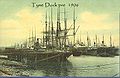 The River Tyne Docks in 1906
 -
 Tyne Docks 1902
 -
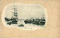
 Tyne Docks 1886
 -
 The sands South Shields 1903
 -
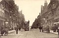 King Street 1905
 -
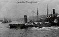
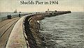 South Shields pier in 1904
 -
 Early 1900’s Tyne Ferry Boat
 -
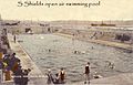 Not many people know South Shields once had an open air swimming pool
 -
 Market Place 1904
 -
 King Street 1906
 -
 King Street 1904
 -
 Early 20th century South Shields Pier


See also
References
- ^ Office for National Statistics : Census 2001 : Urban Areas : Table KS01 : Usual Resident Population Retrieved 2009-08-26
- ^ a b "Arbeia Fort and Settlement". 2005-03-07. Retrieved 2007-10-24.
The sixteenth-century antiquary, John Leland, gives the name as Caer Urfa, which appears to be a simple corruption of the earlier Roman name, prefixed by Caer, a Welsh word meaning 'a fortified place' which is typical of the early Saxon era. The modern name is first recorded in 1235 as Scheles, which is a Middle English term for a group of makeshift huts or shelters
{{cite web}}: CS1 maint: date and year (link) - ^ "South Shields Tyneside Tower Blocks and Togers". Time Team, Channel4. 2005-03-20. Retrieved 2008-01-17.
South Shields is well known for the Roman fort of Arbeia at the end of Hadrian's Wall. A few tombstones and burials have been found here in the past hundred years, but these account for only a small fraction of the legionaries and others who must have been buried on this site.
{{cite web}}: CS1 maint: date and year (link) - ^ "Time Team Series 12 South Shields, Tyneside. Tower blocks and togas". Time Team, Channel4. 2005-03-20. Retrieved 2008-01-17.
{{cite web}}: Cite has empty unknown parameter:|month=(help)CS1 maint: date and year (link) - ^ World dictionary of foreign expressions. Bolchazy-Carducci Publishers. 1999. ISBN 0865164231, 9780865164239.
Vide infra [i]abbr.[/i] V.I. or v.i. v. [L.vide see (1); infra below, beneath (2): See below.] Used in books to refer the reader to a subsequent passage or item. See vide post.
{{cite book}}: Check|isbn=value: invalid character (help); Unknown parameter|coauthors=ignored (|author=suggested) (help) - ^ Swanton, Michael (1996). The Anglo Saxon Chronicles. p. 287. ISBN 0-460-87737-2.
{{cite book}}:|access-date=requires|url=(help) - ^ "Welcome to the Parish Church of South Shields". 2005-03-07. Retrieved 2007-10-24.
{{cite web}}: CS1 maint: date and year (link) - ^ Isaac Cookson at Oxford Dictionary of National Biography
- ^ a b "Industrial Heritage". Retrieved 2008-01-08.
Tyne Dock was opened in 1859 with the capacity to hold 500 vessels.
- ^ "Tate.org.uk - after Joseph Mallord William Turner 1775-1851". 1823. Retrieved 2007-12-22.
Shields, on the River Tyne, engraved by C.Turner 1823
- ^ "South Shields History". Retrieved 2007-12-23.
Today it attracts seafaring students from all over the world.
- ^ a b Reed, Angela (2008-07-21). "Planetarium's future saved - with move out of town!". South Shields Gazette. Retrieved 2008-08-21.
THE future of South Tyneside College's planetarium and observatory has been secured – with a move outside the borough.
- ^ "History of North East Press". Shields Gazette. Johnston Press. Retrieved 2007-05-20.
The Gazette is the UK's oldest provincial evening newspaper and was first published in 1849.
- ^ BBC - Tyne - History - The King of South Shields: A knockout royal visit
- ^ "Tyne Salmon Trail". 2008. Retrieved 2008-08-22.
Ten cubes inspired by the textures, changing colours, movement and journey of the salmon will migrate along the River Tyne, following the amazing journey of the salmon.
- ^ Strug, Leah (2008-07-21). "Attraction's sending art lovers fishy messages". South Shields Gazette.
{{cite news}}: CS1 maint: date and year (link) - ^
"Dame Catherine Cookson". Retrieved 2007-12-22.
4. Sir William Fox Hotel, Westoe village, South Shields. This conservation village was the setting for many of her books including Katie Mulholland and Kate Hannigan.
- ^ The British Yemeni Society
- ^ The North East's Yemeni Race Riots
- ^ American Institute for Yemeni Studies
- ^ David Miliband MP - Maiden Speech to Parliament
- ^ Reed, Angela (2008-08-08). "MP backs moves to mark Muhammad Ali's South Shields visit". South Shields Gazette. Retrieved 2008-08-16.
Ms Gharavi, from South Shields, creative director of Bridge + Tunnel Productions in Newcastle, said: "Mr Miliband's support for the plaque project is exciting and has brought momentum to the campaign. "I'm sure the people of South Shields will be glad to hear that it is another step closer to reality.
- ^ a b c "Version 5, Change in Claimant Count / Unemployment rate in the borough". southtyneside.info. 2008-05-05. Retrieved 2008-08-30.
- ^ "Foreshore set for big revamp". South Shields Gazette. 2007-03-13. Retrieved 2007-12-24.
{{cite news}}: CS1 maint: date and year (link) - ^ "Awards". Colmans Fish and Chip Restaurant. Cooldot Web Design. Retrieved 2008-11-28.
- ^ Staines, Shelly (2008-03-07). "Chip Shop Helps Embassy Offer Right Royal Treat". Shields Gazette.
{{cite news}}:|access-date=requires|url=(help) - ^ Sharma, Sonia (2008-03-06). "His Royal Fryness". Evening Chronicle.
{{cite news}}:|access-date=requires|url=(help) - ^ "College Info - Courses by Subject". South Tyneside College. 2008. Retrieved 2008-08-21.
- ^ "ANY QUESTIONS?". South Shields Gazette. 2007-02-09. Retrieved 2008-01-19.
{{cite news}}: CS1 maint: date and year (link) - ^ Shaw, Leah (2007-02-10). "PARENTS MEET TO DISCUSS CONCERNS OVER SUPERSCHOOL". The South Shields Gazette. Retrieved 2008-01-19.
"King George V and Brinkburn schools will merge on April 16 to form South Shields Community School on split sites in Nevinson Avenue and McAnany Avenue. "Pupils will then move to Brinkburn School's buildings while a new £19m superschool, due to open in 2009 at the earliest…"
{{cite web}}: CS1 maint: date and year (link) - ^ "AskOxford.com". Retrieved 2007-10-13.
- ^ Dickens, Jnr, Charles (1872). All the Year Round. new ser.:v.8. Charles Dickens. p. 487.
the engineer, a brawny Geordie from South Shields, imbued with a thoroughly English contempt for every thing foreign;
{{cite book}}:|access-date=requires|url=(help) - ^ "Not Only A Hero, An Illustrated Life of Simpson, the Man with the Donkey". Retrieved 2007-11-05.
- ^ "Not Only A Hero, Tyneside". Retrieved 2007-11-05.
- ^ "Not Only A Hero, Jack in Australia". Retrieved 2007-11-05.
- ^ "Not Only A Hero, Training". Retrieved 2007-11-05.
- ^ "Not Only A Hero, The Landing". Retrieved 2007-11-05.
- ^ "Not Only A Hero, The Donkey". Retrieved 2007-11-05.
- ^ "Not Only A Hero, The Clown Prince". Retrieved 2007-11-05.
- ^ "Not Only A Hero, Anzac Cove". Retrieved 2007-11-05.
- ^ "Not Only A Hero, May 19th". Retrieved 2007-11-05.
- ^ "Not Only A Hero, Monuments to Jack Simpson". Retrieved 2007-11-05.
- ^ "South Tyneside College RFC". Retrieved 2008-05-25.
- ^ "Westoe RFC". Official site. Westoe RFC. Retrieved 2008-09-08.
- ^ a b "Westoe RFC History". Official site. Westoe RFC. Retrieved 2008-09-08.
- ^ "WESTOE GRIT WIPES STAINES CLEAN AWAY". South Shields Gazette. 2005-03-07. Retrieved 2007-10-24.
- ^ 2005 General Election results - South Shields
- ^ "South Tyneside Alliance". Politics. southtynesidealliance.info. Retrieved 2008-08-30.
- ^
"Ferry gets first woman boss in 700 years". Shields Gazette. Johnston Press. 2008-08-12. Retrieved 2008-08-16.
There has been a ferry service between North Shields and South Shields since 1377.
External links
- South Tyneside Council & Community website - Local council website
- [1] History website of South Shields
- [2] - Arbeia information website
- [3] St. Hilda's Parish website
- South Shields Sanddancers - Local Information website
- Curly's Corner Shop, the blog! Local commentary
- Café Buttercups - local coffee shop, sandwich bar, catering and buffet services
- Photos of South Shields
- South Shields Daily Photo A South Shields or North of England picture every day, comments invited
- South Shields: The Sites, The People, The Place - Tourist Information Website
- Boarding House, a 2009 short documentary film about the Yemeni community in South Shields, by David Campbell