
Herat: Difference between revisions
m robot Adding: lmo:Herat |
demography section + sources |
||
| Line 95: | Line 95: | ||
Herāt lies on the ancient [[trade route]]s of the [[Middle East]], [[Central Asia|Central]] and [[South Asia]]. The roads from Herāt to [[Iran]], Turkmenistan, [[Mazar-e Sharif]] and [[Kandahar]] are still strategically important. The city is the gateway to Iran, collecting the highest amount of customs revenue for Afghanistan.<ref>http://news.bbc.co.uk/2/hi/south_asia/8180832.stm</ref> |
Herāt lies on the ancient [[trade route]]s of the [[Middle East]], [[Central Asia|Central]] and [[South Asia]]. The roads from Herāt to [[Iran]], Turkmenistan, [[Mazar-e Sharif]] and [[Kandahar]] are still strategically important. The city is the gateway to Iran, collecting the highest amount of customs revenue for Afghanistan.<ref>http://news.bbc.co.uk/2/hi/south_asia/8180832.stm</ref> |
||
==Climate== |
|||
| ⚫ | |||
| ⚫ | |||
| ⚫ | |||
| ⚫ | |||
| ⚫ | |||
| ⚫ | |||
| ⚫ | |||
| ⚫ | |||
| ⚫ | |||
| ⚫ | |||
| ⚫ | |||
| ⚫ | |||
| ⚫ | |||
| ⚫ | |||
| ⚫ | |||
| ⚫ | |||
| ⚫ | |||
| ⚫ | |||
| ⚫ | The winter is tolerably mild; snow melts as it falls, and even on the mountains does not lie long. Three years out of four it does not freeze hard enough for the people to store ice. The eastern reaches of the Hari River, including the rapids, are frozen hard in the winter, and people travel on it as on a road. |
||
==History== |
==History== |
||
[[File:Median Empire.jpg|thumb|200px|left|During the period of the [[Medes|Median Empire]] (about 600 BCE) and the [[Achaemenid Empire]] (ca. 550-330 BC), Herāt was often recognized as '''Aria'''.]] |
[[File:Median Empire.jpg|thumb|200px|left|During the period of the [[Medes|Median Empire]] (about 600 BCE) and the [[Achaemenid Empire]] (ca. 550-330 BC), Herāt was often recognized as '''Aria'''.]] |
||
| Line 151: | Line 172: | ||
By 2009, Iran invested funds into Herāt. As a result, Herāt now enjoys 24-hour electricity, well-paved roads, and a higher sense of security than other Afghan cities. Some locals jokingly called Herāt the "[[Dubai]] of [[Afghanistan]]."<ref>Motlagh, Jason. "[http://www.time.com/time/world/article/0,8599,1900013,00.html?xid=rss-topstories-cnnpartner Iran's Spending Spree in Afghanistan]." ''[[TIME (magazine)|TIME]]''. Wednesday May 20, 2009. Retrieved on May 24, 2009.</ref> |
By 2009, Iran invested funds into Herāt. As a result, Herāt now enjoys 24-hour electricity, well-paved roads, and a higher sense of security than other Afghan cities. Some locals jokingly called Herāt the "[[Dubai]] of [[Afghanistan]]."<ref>Motlagh, Jason. "[http://www.time.com/time/world/article/0,8599,1900013,00.html?xid=rss-topstories-cnnpartner Iran's Spending Spree in Afghanistan]." ''[[TIME (magazine)|TIME]]''. Wednesday May 20, 2009. Retrieved on May 24, 2009.</ref> |
||
== |
== Demography == |
||
The population of Herat numbers 397,500.<ref>[http://www.mrrd.gov.af/nabdp/Provincial%20Profiles/Herat%20PDP%20Provincial%20profile.pdf UNDSS Provincial Profile], Afghanistan's "Ministry of Rural Rehabilitation and development (MRRD)", 2009</ref> [[Persian language|Persian-speaking]] [[Tajik people|Tajiks]] and [[Farsiwan]] form the overwhelming majority of the city, comprising ca. 80%. [[Pashtun people|Pashtuns]] (10%), [[Hazara people|Hazaras]] (2%), [[Uzbek people|Uzbeks]] (2%), and [[Turkmen people|Turkmens]] (1%) form sizable minorities.<ref>[http://ngm.nationalgeographic.com/ngm/0311/feature2/images/mp_download.2.pdf Population Map], [[National Geographic]], 2003</ref> |
|||
| ⚫ | |||
| ⚫ | |||
| ⚫ | |||
| ⚫ | |||
| ⚫ | |||
| ⚫ | |||
| ⚫ | |||
| ⚫ | |||
| ⚫ | |||
| ⚫ | |||
| ⚫ | |||
| ⚫ | |||
| ⚫ | |||
| ⚫ | |||
| ⚫ | |||
| ⚫ | |||
| ⚫ | |||
| ⚫ | |||
| ⚫ | The winter is tolerably mild; snow melts as it falls, and even on the mountains does not lie long. Three years out of four it does not freeze hard enough for the people to store ice. The eastern reaches of the Hari River, including the rapids, are frozen hard in the winter, and people travel on it as on a road. |
||
==Transport== |
==Transport== |
||
Revision as of 22:27, 25 October 2009
This article needs additional citations for verification. (May 2009) |
Herāt
هرات | |
|---|---|
City | |
 View from citadel | |
| Country | |
| Province | Herat Province |
| District | Herat District |
| Elevation | 920 m (3,020 ft) |
| Population (2006) | |
| • Total | 349,000 |
| Central Statistics Office of Afghanistan | |
| Time zone | UTC+4:30 (Afghanistan Standard Time) |
Herāt (Persian: هرات), classically called the Aria, is a major city in western Afghanistan, in the province also known as Herāt. It is situated in the valley of the Hari River, which flows from the mountains of central Afghanistan to the Karakum Desert in Turkmenistan. It is the third largest city of Afghanistan, with a population of 349,000 (2006 official estimate). Persian-speaking Tajiks (or Fārsīwān) are the main inhabitants of the city, and are roughly the same as the Persians of Eastern Iran.[1][2]
Situated in a fertile area, Herāt was traditionally known for its wine. It is a very old city with many historic buildings, although these have suffered damage in various military conflicts during the last few decades. The city is dominated by the remains of a citadel constructed by Alexander the Great. During the Middle Ages Herāt became one of the important cities of Khorasan, it was known as the Pearl of Khorasan.
Herāt lies on the ancient trade routes of the Middle East, Central and South Asia. The roads from Herāt to Iran, Turkmenistan, Mazar-e Sharif and Kandahar are still strategically important. The city is the gateway to Iran, collecting the highest amount of customs revenue for Afghanistan.[3]
Climate
| Herāt | ||||||||||||||||||||||||||||||||||||||||||||||||||||||||||||
|---|---|---|---|---|---|---|---|---|---|---|---|---|---|---|---|---|---|---|---|---|---|---|---|---|---|---|---|---|---|---|---|---|---|---|---|---|---|---|---|---|---|---|---|---|---|---|---|---|---|---|---|---|---|---|---|---|---|---|---|---|
| Climate chart (explanation) | ||||||||||||||||||||||||||||||||||||||||||||||||||||||||||||
| ||||||||||||||||||||||||||||||||||||||||||||||||||||||||||||
| ||||||||||||||||||||||||||||||||||||||||||||||||||||||||||||
Although Herāt is approximately 240 m (790 ft) lower than Kandahar, the summer climate is more temperate, and the climate throughout the year is far from disagreeable. From May to September, the wind blows from the northwest with great force.
The winter is tolerably mild; snow melts as it falls, and even on the mountains does not lie long. Three years out of four it does not freeze hard enough for the people to store ice. The eastern reaches of the Hari River, including the rapids, are frozen hard in the winter, and people travel on it as on a road.
History

| History of Afghanistan |
|---|
 |
| Timeline |
According to a recent study by German archeologists, Herat is believed to be 2,700 years old.[4] During the period of the Achaemenid Empire (ca. 550-330 BC), the surrounding district was known as Haraiva (in Old Persian), and in classical sources the region was correspondingly known as Aria (Areia). In the Zoroastrian Avesta, the district is mentioned as Haroiva. The name of the district and its main town is derived from that of the chief river of the region, the Hari River (Old Iranian Harayu, "with velocity"), which traverses the district and passes some 5 km (3.1 mi) south of modern Herāt. The naming of a region and its principal town after the main river is a common feature in this part of the world—compare the adjoining districts/rivers/towns of Arachosia and Bactria.
The district Aria of the Persian Achaemenid Empire is mentioned in the provincial lists that are included in various royal inscriptions, for instance, in the Behistun inscription of Darius I (ca. 520 BC).[5] Representatives from the district are depicted in reliefs, e.g., at the royal Achaemenid tombs of Naqsh-e Rustam and Persepolis.
Herodotus described Herāt as the bread-basket of Central Asia. At the time of Alexander the Great, Aria was obviously an important district. It was administered by a satrap called Satibarzanes, who was one of the three main Persian officials in the East of the Empire, together with the satrap Bessus of Bactria and Barsaentes of Arachosia. In late 330 BC, Alexander the Great captured the Arian capital that was called Artacoana. The town was rebuilt and the citadel was constructed. It became part of the Seleucid Empire but was captured by others on various occasions and became part of the Parthian Empire in 167 BC.
In the Sasanian period (226-652), Harēv is listed in an inscription on the Ka'ba-i Zartosht at Naqsh-e Rustam; and Hariy is mentioned in the Pahlavi catalogue of the provincial capitals of the empire. In around 430, the town is also listed as having a Christian community, with a Nestorian bishop.
In the last two centuries of Sasanian rule, Aria (Herāt) had great strategic importance in the endless wars between the Sasanians, the Chionites and the Hephthalites who had been settled in modern northern Afghanistan since the late fourth century.
Islamic conquest

The city of Herāt became well known with the advent of the Arabs in the middle of the seventh century. When the Arab armies appeared in Khorasan in the 650s, Herāt was counted among the twelve capital towns of the Sasanian Empire. Herāt was taken in AD 652 by General Abdul Rehman ibn Samrah. Around 786-809, Herāt was part of the Abbasid Caliphate, later, it was ruled by the Tahirid dynasty, and after 867-869, the Saffarid dynasty took control.
Herāt was under the rule of King Nuh II of Samanid[6]—the seventh of the Samanid line—at the time of Sebük Tigin and his older son, Mahmud of Ghazni.
The governor of Herāt was a noble by the name of Faik[citation needed] , who governed on behalf of Nuh II. Faik was a powerful, but insubordinate governor of Nuh II; and had been punished by Nuh II. Faik made overtures to Bogra Khan and Ughar Khan of Turkestan. Bogra Khan answered Faik's call, came to Herāt and became its master. The Samanids fled, betrayed at the hands of Faik to whom the defence of Herāt had been entrusted by Nuh II.
In 994, Nuh II invited Alp Tigin to come to his aid. Alp Tigin, along with Mahmud of Ghazni, defeated Faik and annexed Herāt, Nishapur and Tous. [7]
Before 1040, Herāt was ruled by the Ghaznavids. In 1040, it was captured by the Seljuk Empire. Yet, in 1175, it was captured by the Ghorids and then came under the Khawarazm Empire. In this period Herāt became an important center for the production of metal goods, especially in bronze, often decorated with elaborate inlays in precious metals.
Herāt was captured by the Mongols in 1221 and destroyed by Genghis Khan. The city was given to one of Ghenghis Khan's sons, Tuli, but the locals revolted and killed the mongol garrison. After hearing the news, Genghis Khan rode furiously upon the city with 80,000 soldiers and besieged it for about six months, killing everyone except some forty.[8] In 1245, it was given to the Kart Maliks. Around 1381, the city was destroyed again by Timur. Under his son Shah Rukh Herāt was rebuilt and became an important center under the Timurid Empire. In the late 1400s, the Musallah complex, with many minarets, was built under the rule of Queen Gawharshad. Her tomb complex is considered one of the great monuments of Timurid architectural carving. The Black Sheep Turkomans (Qara Qoyunlu) at one point established their capital in Herāt during the fifteenth century[9], and in 1506 it was captured by the Uzbeks. Only few years later the city was taken by Shah Ismail Safavi, to become part of a new Safavid Persian Empire. Mughal Emperor Babur, who had his first drink of wine in Herat, visited the city in early 1500s but decided to abandon it.[10]
Modern history
In 1710 the city fell to Mirwais Khan Hotak and was ruled by the Ghilzai Afghans until 1736 when Nader Shah Afsharid swept through with his Afsharid forces. After Nader Shah's death in 1747, Ahmad Shah Durrani took possession of Herāt after almost a year of siege and bloody conflict, and the city became part of the Durrani Empire. In 1824, the city became independent for several years when the Empire was split between the Durranis and the Barakzais. The city was invaded by the Persians in 1852 and again in 1856; both times the British helped to repel the invaders, the second time through the Anglo-Persian War. The city fell to Dost Mohammad Khan of the Barakzai dynasty in 1863.
Most of the Musallah complex in Herat was cleared in 1885 by the British army to get a good line of sight for their artillery against Russian invaders who never came. This was but one small sidetrack in the Great Game, a century-long conflict between the British Empire and the Russian Empire in 19th century.

During the Democratic Republic of Afghanistan, Herat Airport was used by the Soviet forces. Even before the Soviet invasion at the end of 1979, there was a substantial presence of Soviet advisors in the city with their families. From 10 to 20 March 1979 the army in Herāt under the control of Ismail Khan mutinied, and some 35 Soviet citizens were killed. The Afghan Air Force, aided by the Red Army, bombed the city, causing massive destruction and some 24,000 civilian deaths. City itself was recaptured with tanks and airborne forces.
Ismail Khan became the leading Mujahedin commander in Herāt. After the departure of the Soviets, he became governor of Herāt. In September 1995 the city was captured by the Taliban without much resistance, forcing Ismail Khan to flee. However, after the US invasion of Afghanistan, on November 12, 2001, it was liberated from the Taliban by the Northern Alliance and Ismail Khan returned to power (see Battle of Herat). In 2004, Mirwais Sadiq, Aviation Minister of Afghanistan and the son of Ismail Khan, was ambushed and killed in Herāt by a local rival group. More than 200 people were arrested under suspicion of involvement.[11]
Herāt is presently in full control of Afghanistan's new central government, led by Hamid Karzai, who was initially backed by the United States. The Afghan National Army and the Afghan National Police provide security in the city as well as the whole province. There are also presence of the International Security Assistance Force (ISAF) peacekeeping forces in the area, which is led by Italy and assisting the Military of Afghanistan.
By 2009, Iran invested funds into Herāt. As a result, Herāt now enjoys 24-hour electricity, well-paved roads, and a higher sense of security than other Afghan cities. Some locals jokingly called Herāt the "Dubai of Afghanistan."[12]
Demography
The population of Herat numbers 397,500.[13] Persian-speaking Tajiks and Farsiwan form the overwhelming majority of the city, comprising ca. 80%. Pashtuns (10%), Hazaras (2%), Uzbeks (2%), and Turkmens (1%) form sizable minorities.[14]
Transport
Air
Rail
In 2007, Iran and Afghanistan finalized an agreement for the establishment of a rail service between the two countries. Construction of the 191 km (119 mi) railway, from Khaf in Iran to Herāt, is in progress on the Iranian side of the border [15]. There is also the prospect of an extension across Afghanistan to Sher Khan Bandar. See railway stations in Afghanistan.
Tourism and sightseeing


- City Districts
- Shahr-e Naw (Downtown)
- Welayat (Office of the governor)
- Qol-Ordue (Army's HQ)
- Farqa (Army's HQ)
- Darwaze Khosh
- Chaharsu
- Pul-e rangine
- Sufi-abad
- New-abad
- Pul-e malaan
- Thakhte Safar
- Howz-e-Karbas
- Baramaan
- Darwaze-ye Qandahar
- Darwaze-ye Iraq
- Darwaze Az Kordestan
- Hotels
- Serena Hotel (coming soon)
- Diamond Hotel
- Marcopolo Hotel
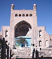
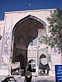
- Monuments
- Citadel of Alexander
- Mosallah Complex
- Herat Old Fort
- Museums
- Herāt National Museum (currently closed, relocating to the Citadel)
- Jihad Museum
- Mosques
- Masjid-e Jame (Friday Mosque)
- Gazargah Sharif
- Khalghe Sharif
- Shah Zahdahe
- Parks
- Park-e Taraki
- Park-e Millat
- Khane-ye Jihad Park
- Stadiums
- Herat Stadium
- Universities
Historical minarets
Of the more than dozen minarets that once stood in Herāt, many have been toppled from war and neglect over the past century. Recently, however, everyday traffic threatens many of the remaining unique towers by shaking the very foundations they stand on. Cars and trucks that drive on a road encircling the ancient city rumble the ground every time they pass these historic structures.UNESCO personnel and Afghan authorities have been working to stabilize the Fifth Minaret.[16][17]
Famous people from Herāt
- Khwājah Abdullāh Ānsārī, a famous Persian poet of the 11th century
- Nūr ud-Dīn Jāmī, a famous Persian Sufi poet of the 15th century
- Nizām ud-Din ʿAlī Shīr Navā'ī, famous poet and politician of the Timurid era
- Ustād Kamāl ud-Dīn Behzād, the greatest of the medieval Persian painters
- Gowharšād, wife of Shāhrūkh Mīrzā
- Mīrzā Shāhrūkh bin Tīmur Barlas, Emperor of the Timurid Dynasty of Herāt
- Mīrzā Husseyn Bāyqarāh, Emperor of the Timurid Dynasty of Herāt
- Shāh Abbās The Great, Emperor of Safavid Persia
- Abbās Qullī Khān Shāmlū, Safavid Governor of Herāt (1812)
- Latīf Nazemī, famous poet of modern times
- Mowlānā Fayzānī, famous reformer and philosopher of the 20th century
- Amīr Jān Ṣabūrī, famous composer and singer from Adraskan District
Gallery
- Images of Herāt
-
-
 Portal
 -
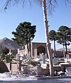 Cemetery
 -
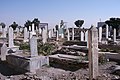 Cemetery
 -
 The ancient citadel sometimes attributed to Alexander the Great
 -
A commercial center in Herāt
-
 Clothes bazaar
 -
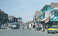 Street


Herāt in fiction
- The beginning of Khaled Hosseini's 2007 novel A Thousand Splendid Suns is set in and around Herāt.
- Salman Rushdie's novel The Enchantress of Florence makes frequent reference to events in Herāt in the middle ages.
References
- ^ H. F. Schurmann, The Mongols of Afghanistan: an Ethnography of the Moghols and Related Peoples of Afghanistan. The Hague: Mouton, 1962:[1] ; p. 75: "... the Tajiks of Western Afghanistan [are] roughly the same as the Khûrâsânî Persians on the other side of the line ..."
- ^ Afghanistan's Provinces– Herat at NPS
- ^ http://news.bbc.co.uk/2/hi/south_asia/8180832.stm
- ^ Pajhwok Afghan News, Archaeologists say Herat 2,700 years old, October 8, 2009.
- ^ Translated by Herbert Cushing Tolman. "The Behistan Inscription of King Darius". Vanderbilt University, Nashville, Tennessee.
- ^ See talk page at Nuh II of Samanid—there seems to be some ambiguity with Nuh II and Nuh III.
- ^ Skrine, Francis Henry; Ross, Edward Denison (2004). The heart of Asia: a history of Russian Turkestan and the Central Asian Khanates from the earliest times. Routledge. p. 117. ISBN 9780700710171.
- ^ http://www.intercontinentalkabul.com/Herat.htm
- ^ Patrick Clawson (2005). Eternal Iran. Palgrave Macmillan. p. 23. ISBN 1-4039-6276-6.
- ^ Packard Humanities Institute - Persian Literature in Translation - Memoirs of Babur
- ^ "More arrests after Herat killing". BBC News. 2004-03-25.
- ^ Motlagh, Jason. "Iran's Spending Spree in Afghanistan." TIME. Wednesday May 20, 2009. Retrieved on May 24, 2009.
- ^ UNDSS Provincial Profile, Afghanistan's "Ministry of Rural Rehabilitation and development (MRRD)", 2009
- ^ Population Map, National Geographic, 2003
- ^ Railway Gazette: Opening up Afghan trade route to Iran
- ^ Bendeich, Mark (June 25, 2007). "Cars, Not War, Threaten Afghan Minarets". Islam Online. Retrieved 2009-09-24.
- ^ Podelco, Grant (July 18, 2005). "Afghanistan: Race To Preserve Historic Minarets of Herat, Jam". Radio Free Europe/Radio Liberty. Retrieved 2009-09-24.
This article incorporates text from a publication now in the public domain: Chisholm, Hugh, ed. (1911). Encyclopædia Britannica (11th ed.). Cambridge University Press. {{cite encyclopedia}}: Missing or empty |title= (help)
See also
External links
- Heratonline.com: Information and news about Herāt
- Herat.co.uk
- Detailed map of Herāt city
- Map of Herāt and surroundings in 1942, Perry-Castañeda Library Map Collection, University of Texas, Austin
- A satellite view map of Herāt.
- Herat a leading city in Afghanistan
- Photo Gallery of Herat
- Poyaa.com - Local News From Herāt
- FallingRain Map - elevation 933 metres (3,061 ft)
- Three Women of Herat: A Memoir of life, Love and Friendship in Afghanistan" by Veronica Doubleday
- Ethnomusicological Research in Afghanistan:
| Periods |
|  | ||||
|---|---|---|---|---|---|---|
| Types | ||||||
| Elements | ||||||
| Traditional cities | ||||||
| Theory and analysis | ||||||
| Lists | ||||||
| Districts |  | |
|---|---|---|
| Populated places | ||
| Landmarks | ||