Salcete taluka: Difference between revisions
Nolicamaca (talk | contribs) No edit summary Tags: Mobile edit Mobile web edit |
Nolicamaca (talk | contribs) No edit summary Tags: Mobile edit Mobile web edit |
||
| Line 63: | Line 63: | ||
</ref> Historically, the sixty-six villages south of the [[Zuari River|Zuari river]] formed the original Salcette territory.<ref>Rodrigues 1990, p. 231</ref> Salcete forms a part of the bigger [[Konkan region]] thats stretches along much of India's north-western shoreline.<ref>{{cite book|title=Gram Panchayats in Goa: A Critical Study|last=Halarnakar|first=Tanaji D.|publisher=Rajhauns Vitaran|year=1990|page=48}}</ref> |
</ref> Historically, the sixty-six villages south of the [[Zuari River|Zuari river]] formed the original Salcette territory.<ref>Rodrigues 1990, p. 231</ref> Salcete forms a part of the bigger [[Konkan region]] thats stretches along much of India's north-western shoreline.<ref>{{cite book|title=Gram Panchayats in Goa: A Critical Study|last=Halarnakar|first=Tanaji D.|publisher=Rajhauns Vitaran|year=1990|page=48}}</ref> |
||
In the erstwhile [[Portuguese |
In the erstwhile [[Portuguese Goa and Damaon]], the [[municipality]] of the ''Salcette [[concelho]]'' located in the ''[[Velhas Conquistas]]'' (Old Conquests), was co-[[railway terminal|terminous]] within the undivided Salcette (Salcete and [[Mormugao taluka]]s).<ref>{{cite book|title=Houses of Goa|last1=Pandit|first1=Heta|last2=Mascarenhas|first2=Annabel|last3=Koshy|first3=Ashok|last4=Dalvi|first4=Sunita|date=1999|publisher=Architecture Autonomous|edition=2, illustrated|page=15}}</ref> In 1917, the territory was bifurcated into the present-day talukas.<ref name="mmg"> |
||
{{cite book |
{{cite book |
||
| last = Pinho |
| last = Pinho |
||
Revision as of 09:07, 13 July 2022
Salcete
Saxtti/Xaxtti Salcette | |
|---|---|
Taluka (sub-district) | |
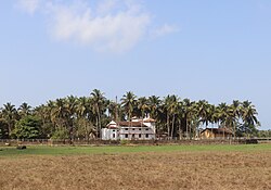
 Salcete countryside | |
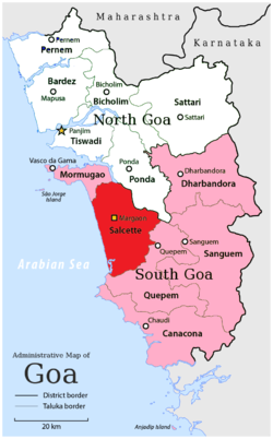
 Location of Salcete in South Goa, Goa | |
| Coordinates: 15°12′45″N 74°04′24″E / 15.212450°N 74.07323°E | |
| Country | |
| State | Goa |
| District | South Goa |
| Headquarters | Margao |
| Settlements (as of 2011) | 2 cities 11 towns 35 villages |
| Government | |
| • Deputy Collector | Jyoti Kumari, IAS[1] |
| • Talukadar[1] | Prataprao Gaunkar |
| Population (2011)[2] | |
| • Total | 294,504 |
| Demonym | Saxtticar/Xaxtticar |
| PIN | 4036XX, 4037XX |
| Vehicle registration | GA-08 |
Salcete (Goan Konkani: साष्टी/षाष्टी, sāṣṭī/ṣāṣṭī; Romi Konkani: Xaxtti; Template:Lang-pt) is a sub-division of the South Goa district, for the purpose of local administration in the Goa state, situated by the south-west coast of India.[3] The Sal river and its backwaters dominate the landscape of Salcete.[4] Historically, the sixty-six villages south of the Zuari river formed the original Salcette territory.[5] Salcete forms a part of the bigger Konkan region thats stretches along much of India's north-western shoreline.[6]
In the erstwhile Portuguese Goa and Damaon, the municipality of the Salcette concelho located in the Velhas Conquistas (Old Conquests), was co-terminous within the undivided Salcette (Salcete and Mormugao talukas).[7] In 1917, the territory was bifurcated into the present-day talukas.[8] The contemporary Salcette taluka of the civil district of South Goa is a rurban area.[9] Margao serves as the administrative headquarters of both Salcete taluka and the South Goa district.[10]
Etymology
'Salcete' is the anglicised spelling of the lusitanised version "Salcette" that was derived from the Konkani word "Saxtti" which in turn is a corruption of the Sanskrit word "षट-षष्टि" ṣaṭ-ṣaṣṭi[a] meaning "sixty-six".[11] According to Hindu mythology of the Konkan, the original sixty-six settlements of the Salcette territory were established by sixty-six Saraswat Brahmin clans who had emigrated here from northern India.[12] In Konkani, the natives are referred to as Saxtticar or Xaxtticar (साष्टीकार/षाष्टीकार; Sāṣṭīkār/ṣāṣṭīkār; IPA: [/'saːʂʈiːkaːɾ/] / [/'ʂaːʂʈiːkaːɾ/]).[3] The Salcete Konkani dialect of southern Goa known as 'Saxtti' is notably different from the 'Antruzi' (Ponda) and 'Bardescari' (Bardez) dialects of northern Goa.[13]
History
King Viramarmadeva of the Kadamba dynasty issued a copper-plate inscription in 1049 CE concerning a grant of a piece of land called Tudukapura in Kudtarika agrahara of Chhat sathi desha. This inscription suggests that Chhat sathi refers to modern Salcete, known as Sāshṭi in the local language.[14]
Salcette territory
Historical Salcette
The original sixty-six settlements of Salcette are as follows:[15]
- Sernabatim
- Vanelim
- Colva
- Seraulim
- Gandaulim
- Duncolim
- Betalbatim
- Nuvem
- Calata
- Gonsua
- Majorda
- Utorda
- Nagoa
- Verna
- Loutulim
- Camurlim
- Ambora
- Raia
- Rachol
- Curtorim
- Nesai
- Macasana
- Guirdolim
- Chandor
- Cavorim
- Paroda
- Mulem
- Sarzora
- Talvorda
- Veroda
- Cuncolim
- Betul
- Velim
- Ambelim
- Assolna
- Cavelossim
- Chinchinim
- Deussua
- Carmona
- Orlim
- Varca
- Sirlim
- Dramapur
- Dicarpale
- Davorlim
- Aquem
- Telaulim
- Navelim
- Margao
- Benaulim
- Adsuli
- Cana
- Mormugao
- Vadem
- Chicalim
- Dabolim
- Sancoale
- Cortalim
- Quelossim
- Cuelim
- Arossim
- Cansaulim
- Velsao
- Pale
- Issorcim
- Chilcona
Contemporary Salcete

Salcete taluka comprises nine comunidades: Benaulim, Betalbatim, Colva, Curtorim, Loutolim, Margao, Nuvem, Raia, and Verna.
The subdistrict consists of two cities, eleven towns, and thirty-five villages as per the 2011 Census of India.
| Salcete Taluka (Census 2011)[2] | ||
|---|---|---|
| # | Settlements | Population |
| Municipal Councils | ||
| 1. | Margao | 87,650 |
| 2. | Cuncolim | 16,623 |
| Census Towns | ||
| 1. | Davorlim | 15,350 |
| 2. | Curtorim | 12,886 |
| 3. | Navelim | 12,323 |
| 4. | Benaulim | 11,919 |
| 5. | Raia | 10,706 |
| 6. | São José de Areal | 10,229 |
| 7. | Nuvem | 9,288 |
| 8. | Chinchinim | 6,908 |
| 9. | Verna | 6,632 |
| 10. | Aquem | 6,511 |
| 11. | Varca | 5,439 |
| Villages | ||
| 1. | Adsulim | 214 |
| 2. | Ambelim | 2,853 |
| 3. | Assolna | 3,410 |
| 4. | Betalbatim | 3,551 |
| 5. | Calata | 1,739 |
| 6. | Camurlim | 2,247 |
| 7. | Cana | 494 |
| 8. | Carmona | 3,864 |
| 9. | Cavelossim | 1,955 |
| 10. | Cavorim | 2,228 |
| 11 | Chandor | 707 |
| 12. | Colva | 3,141 |
| 13. | Deussua | 1,479 |
| 14. | Dicarpale | 3,057 |
| 15. | Dramapur | 3,441 |
| 16. | Duncolim | 748 |
| 17. | Gandaulim | 438 |
| 18. | Gonsua | 222 |
| 19. | Guirdolim | 3,622 |
| 20. | Loutolim | 6,121 |
| 21. | Macasana | 1,972 |
| 22. | Majorda | 2,813 |
| 23. | Mulem | 2,799 |
| 24. | Nagoa | 3,873 |
| 25. | Orlim | 2,049 |
| 26. | Paroda | 620 |
| 27. | Rachol | 1,686 |
| 28. | Sarzora | 2,270 |
| 29. | Seraulim | 3,250 |
| 30. | Sernabatim | 1,548 |
| 31. | Sirlim | 845 |
| 32. | Talaulim | 2,911 |
| 33. | Utorda | 2,018 |
| 34. | Vanelim | 1,860 |
| 35. | Velim | 5,955 |
| Total | 2,94,504 | |
Notes
- ^ Founded by the immigrant Brahmins (circa 4–12 CE), Salcette is the Portuguese corruption of the word Sāṣaṭī, the sixty-six settlements.[16]
Citations
- ^ a b "Archived copy". southgoa.nic.in. Archived from the original on 25 March 2021. Retrieved 15 January 2022.
{{cite web}}: CS1 maint: archived copy as title (link) - ^ a b Chandramouli, C. (2015) [2010–11]. "Salcete Taluka — South Goa". Office of the Registrar General and Census Commissioner, India. Government of India. Census Organization of India. Retrieved 12 December 2019.
- ^ a b Sequeira, Newton (21 December 2014). "The true soul of Goa's South". The Times of India. Retrieved 16 April 2020.
- ^ Nambirajan, M. (2007). Coastal Archaeology of Western India: With Special Reference to Goa. Kaveri Books. p. 134. ISBN 9788174790798.
- ^ Rodrigues 1990, p. 231
- ^ Halarnakar, Tanaji D. (1990). Gram Panchayats in Goa: A Critical Study. Rajhauns Vitaran. p. 48.
- ^ Pandit, Heta; Mascarenhas, Annabel; Koshy, Ashok; Dalvi, Sunita (1999). Houses of Goa (2, illustrated ed.). Architecture Autonomous. p. 15.
- ^ Pinho, Vasco (2007). "Snapshots" of Indo-Portuguese history, Volume 1. p. 122.
- ^ Deshpande, Abhijeet. "Exploring Salcete, places near Margao". Indiatimes.com. The Times Group. Retrieved 30 November 2019.
- ^ Deshpande, Abhijeet. "Margao, the cultural capital of Goa". Indiatimes.com. The Times Group. Retrieved 30 November 2019.
- ^ Macdonell, Arthur Anthony (1929). A practical Sanskrit dictionary with transliteration, accentuation, and etymological analysis throughout. London: Oxford University Press. p. 168.
- ^ De Souza, Teotonio R. (1990). De Souza, Teotonio R. (ed.). Goa Through th Ages: An Economic History, Volume II, Issue VI. Goa University Publication. Concept Publishing Company. p. 6. ISBN 9788170222590.
- ^ Fernandes, Joaquim (15 February 2010). "Saxtti dialect draws the laughs on Konkani stage". The Times of India. The Times Group. Retrieved 30 November 2019.
- ^ Kadamb 2013, pp. 1–14
- ^ Rodrigues 1990, p. 245
- ^ Kosambi, Damodar Dharmanand (1962). Myth and Reality: Studies in the Formation of Indian Culture (reprint ed.). Popular Prakashan. p. 169. ISBN 9788171548705.
References
- Kadamb, S. G. (2013). Sources of History of the Kadambas of Goa: Inscriptions (First ed.). Broadway Publishing House. pp. 1–14. ISBN 9789380837314.
- Rodrigues, L. A. (1990). "The Peninsula of Salcete". In Kusuman, K. K. (ed.). A Panorama of Indian Culture: Professor A. Sreedhara Menon Felicitation Volume. Mittal Publications. pp. 231–246. ISBN 9788170992141.
