
Triglav: Difference between revisions
m Dating maintenance tags: {{Fact}} |
added some more material to 'Aljaž Tower' in order to fill the section; copied from Aljaž Tower; more should be added to all section to improve the layout |
||
| Line 36: | Line 36: | ||
[[File:Triglav Aljazev stolp.jpg|thumb|left|Aljaž Tower at the top of the mountain]] |
[[File:Triglav Aljazev stolp.jpg|thumb|left|Aljaž Tower at the top of the mountain]] |
||
{{main|Aljaž Tower}} |
{{main|Aljaž Tower}} |
||
At the top of the mountain stands a small metal structure, the [[Aljaž Tower]] ({{lang-sl|Aljažev stolp}}), symbolic of Slovenian territorial sovereignty. |
At the top of the mountain stands a small metal structure, the [[Aljaž Tower]] ({{lang-sl|Aljažev stolp}}), symbolic of Slovenian territorial sovereignty. Along with Triglav, it is a landmark of Slovenia and a symbol of [[Slovenes]]. |
||
| ⚫ | |||
The tower's namesake was the priest, mountaineer and patriot [[Jakob Aljaž]], who around 1900 purchased the [[Kredarica]] waypoint and the summit for the sum of five [[Austro-Hungarian florin]]s. Having done so, he secured himself the right to erect a building on his own real property. In early 1895, he drew up plans for a cylindrical tower with a flag on its top and ordered its construction.<ref name="Kam">{{cite web |url=http://www.kam.si/izleti/aljazev_stolp_na_triglavu.html |title=Aljažev stolp na Triglavu |first=Andreja |last=Praznik |accessdate=2008-09-12 |language=Slovene}}</ref> |
|||
The tower was carried in parts to the top of Triglav and put together on 7 August 1895. The opening took place that same day. Aljaž donated the shelter to the [[Slovene Mountaineering Society]].<ref name="Matica">{{cite web|url=http://www.planinskodrustvo-ljmatica.si/zgodovina_aljazev_stolp.html|title=Aljažev stolp vrh Triglava|publisher=Mountaneering club Ljubljana-Matica|accessdate=2007-11-13|language=Slovene |archiveurl = http://web.archive.org/web/20071227194809/http://www.planinskodrustvo-ljmatica.si/zgodovina_aljazev_stolp.html <!-- Bot retrieved archive --> |archivedate = 2007-12-27}}</ref> It was later several times repainted and renovated, but has more or less retained its original appearance.<ref name="Gore-ljudje">{{cite web |url=http://www.gore-ljudje.net/novosti/3900/ |title=Stolp ima 110 let |publisher=Gore-ljudje.net |first=Maja |date=2007-07-25 |last=Belimezov |accessdate=2008-09-12 |language=Slovene}}</ref> |
|||
| ⚫ | |||
==Triglav Glacier== |
==Triglav Glacier== |
||
[[File:Burger_Slika_TriglavskiLedenik_Sep_2002.jpg|thumb|Remains of the Triglav Glacier in 2002]] |
[[File:Burger_Slika_TriglavskiLedenik_Sep_2002.jpg|thumb|Remains of the Triglav Glacier in 2002]] |
||
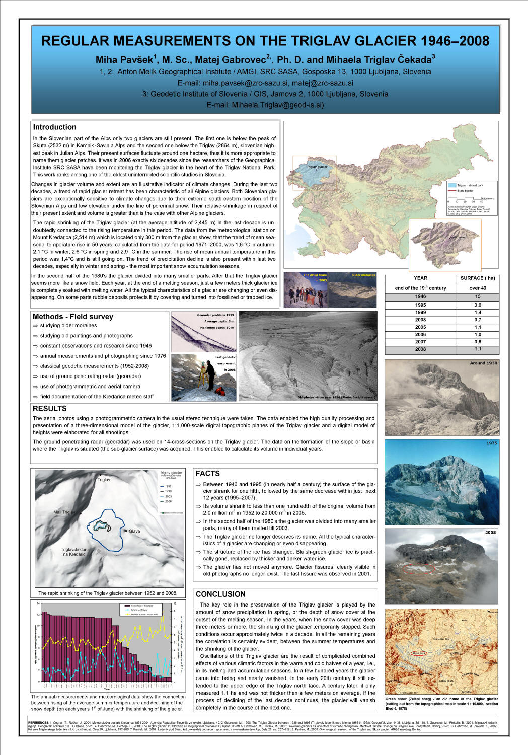
The [[Triglav Glacier]] ({{lang|sl|''Triglavski ledenik''}}) is situated on the northeastern side of the mountain below the summit. Covering over {{convert|40|ha}} at the end of the 19th century, the glacier shrunk to {{convert|15|ha}} until 1946,<ref>{{cite web |url=http://www.gore-ljudje.net/objave/BORKUM/0810Dnevnik/Triglav_Glacier_1946_2008_MM_MTC_MG_1.jpg |title=Regular Measurements on the Triglav Glacier 1946–2008: A Poster |first1=Miha |last1=Pavšek |first2=Matej |last2=Gabrovec |first3=Mihaela |last2=Triglav Čekada |year=2008 |publisher=Geographical Institute of Anton Melik, Scientific Research Centre of the Slovenian Academy of Sciences and Arts}}</ref> and after further shrinkage fell into two parts in 1992.<ref name="ARSO2011-11">{{cite web |url=http://kazalci.arso.gov.si/?data=indicator&ind_id=413 |first1=Matej |last1=Gabrovec |first2=Matej |last2=Pavšek |title=Spreminjanje obsega ledenika |language=Slovene |trans_title=Changes of the Extent of the Glacier |publisher=Environmental Agency of the Republic of Slovenia, Ministry of Agriculture and Environment |date=2 November 2011}}</ref> It now covers an area of 1–3 hectares only, depending on the season.<ref name="ARSO2011-11" /> |
|||
{{-}} |
|||
==Cultural significance== |
==Cultural significance== |
||
{{Expand section|date=December 2009}} |
|||
===Folk literature=== |
===Folk literature=== |
||
The Triglav area is the setting of an old Slovene folktale concerning a hunter seeking a treasure guarded by an enchanted [[chamois]] buck named ''[[Zlatorog]]'' (''Goldhorn'', after its golden horns). |
The Triglav area is the setting of an old Slovene folktale concerning a hunter seeking a treasure guarded by an enchanted [[chamois]] buck named ''[[Zlatorog]]'' (''Goldhorn'', after its golden horns). |
||
| Line 56: | Line 59: | ||
In 1986, the [[Laibach (band)|Laibach]]/[[IRWIN]]/[[Neue Slowenische Kunst]] theater production ''[[Baptism (Laibach album)|Krst pod Triglavom - Baptism Below Triglav]]'' was produced and released as an album. The performance was centered around the theme of Slovenia's conversion to Christianity by invading Germanic peoples.<ref>[http://www.gla.ac.uk/~dc4w/laibach/baptism1986.html Krst Pod Triglavom], ''The Unofficial Laibach Site''.</ref> |
In 1986, the [[Laibach (band)|Laibach]]/[[IRWIN]]/[[Neue Slowenische Kunst]] theater production ''[[Baptism (Laibach album)|Krst pod Triglavom - Baptism Below Triglav]]'' was produced and released as an album. The performance was centered around the theme of Slovenia's conversion to Christianity by invading Germanic peoples.<ref>[http://www.gla.ac.uk/~dc4w/laibach/baptism1986.html Krst Pod Triglavom], ''The Unofficial Laibach Site''.</ref> |
||
{{clear|left}} |
{{clear|left}} |
||
===National symbol=== |
===National symbol=== |
||
A stylized depiction of Triglav's distinctive shape is the central element of the [[Coat of arms of Slovenia|Slovenian coat of arms]], and is in turn featured on the [[flag of Slovenia]] (and, formerly, on the coat of arms of the [[Socialist Republic of Slovenia]]). A Slovene flag was unfurled from the summit of Triglav on 26 June 1991, the night of the declaration of independence of Slovenia from Yugoslavia. A photorealistic relief of the mountain is the design on the national side of the Slovenian [[Slovenian euro coins|50 eurocent coin]]. |
A stylized depiction of Triglav's distinctive shape is the central element of the [[Coat of arms of Slovenia|Slovenian coat of arms]], and is in turn featured on the [[flag of Slovenia]] (and, formerly, on the coat of arms of the [[Socialist Republic of Slovenia]]). A Slovene flag was unfurled from the summit of Triglav on 26 June 1991, the night of the declaration of independence of Slovenia from Yugoslavia. A photorealistic relief of the mountain is the design on the national side of the Slovenian [[Slovenian euro coins|50 eurocent coin]]. |
||
Revision as of 10:58, 3 May 2012
This article needs additional citations for verification. (March 2008) |
| Triglav | |
|---|---|
 Triglav viewed from Debela Peč, 2002 | |
| Highest point | |
| Elevation | 2,864 m (9,396 ft) |
| Prominence | 2,052 m (6,732 ft) |
| Listing | Country high point Ultra |
| Geography | |
 Triglav | |
| Parent range | Julian Alps |
| Climbing | |
| First ascent | 1778 |
| Easiest route | scramble / via ferrata |
Triglav (Italian: Tricorno, German: Terglau) is the highest mountain in Slovenia and the highest peak of the Julian Alps. While its name, meaning "three-headed", can describe its shape as seen from the Bohinj area, the mountain was most probably named after the Slavic god Triglav. The mountain is the preeminent symbol of the Slovene nation. Since 1961, the mountain has been the centerpiece of Triglav National Park, Slovenia's only national park.
History
The ascent on Triglav was connected with the competition between Slovenes and Germans.[citation needed] The first recorded ascent of Triglav was made on 26 August 1778, by Luka Korošec, Matija Kos, Štefan Rožič and Lovrenc Willomitzer, on the initiative of the industrialist and polymath Sigmund Zois. Its height was first measured in 1808 by Valentin Stanič.
During World War II, Triglav symbolically captured the primary drive for the Slovene resistance to the Fascist and Nazi armies, a national liberation.[1] The Slovene Partisans wore the Triglav cap from 1942 until after 1944.[2]
Triglav was the highest peak of (now defunct) Yugoslavia; it was both the most prominent peak and, together with the southern Vardar river (now in Republic of Macedonia), the symbol of Yugoslav "brotherhood and unity".
Aljaž Tower

At the top of the mountain stands a small metal structure, the Aljaž Tower (Slovene: Aljažev stolp), symbolic of Slovenian territorial sovereignty. Along with Triglav, it is a landmark of Slovenia and a symbol of Slovenes.
The tower's namesake was the priest, mountaineer and patriot Jakob Aljaž, who around 1900 purchased the Kredarica waypoint and the summit for the sum of five Austro-Hungarian florins. Having done so, he secured himself the right to erect a building on his own real property. In early 1895, he drew up plans for a cylindrical tower with a flag on its top and ordered its construction.[3]
The tower was carried in parts to the top of Triglav and put together on 7 August 1895. The opening took place that same day. Aljaž donated the shelter to the Slovene Mountaineering Society.[4] It was later several times repainted and renovated, but has more or less retained its original appearance.[5]
Triglav Glacier

The Triglav Glacier ([Triglavski ledenik] Error: {{Lang}}: text has italic markup (help)) is situated on the northeastern side of the mountain below the summit. Covering over 40 hectares (99 acres) at the end of the 19th century, the glacier shrunk to 15 hectares (37 acres) until 1946,[6] and after further shrinkage fell into two parts in 1992.[7] It now covers an area of 1–3 hectares only, depending on the season.[7]
Cultural significance
Folk literature
The Triglav area is the setting of an old Slovene folktale concerning a hunter seeking a treasure guarded by an enchanted chamois buck named Zlatorog (Goldhorn, after its golden horns).
Arts

The earliest know depiction of Triglav is on the front page of the work Oryctographia Carniolica, written by Belsazar Hacquet.[8] It was a copper engraving made in 1778 by C. Conti after a drawing by Franz Xaver Baraga.[9]
Since 1968, a certain provocative controversy has been at work in contemporary Slovene arts. This experimental, retro, avant-garde, "artivistic", and artistic-political controversy seemingly refers to the famed happening of the group OHO's Mount Triglav, which originally took place on 30 December 1968 in Ljubljana's Zvezda Park. It was later resurrected and reimagined, first by the group IRWIN in 2004 as Like to Like/ Mount Triglav, and in 2007, it was performed atop Mount Triglav by the artists Janez Janša (director), Janez Janša (artist) and Janez Janša (performance artist) as Mount Triglav on Mount Triglav.[citation needed]
In 1986, the Laibach/IRWIN/Neue Slowenische Kunst theater production Krst pod Triglavom - Baptism Below Triglav was produced and released as an album. The performance was centered around the theme of Slovenia's conversion to Christianity by invading Germanic peoples.[10]
National symbol
A stylized depiction of Triglav's distinctive shape is the central element of the Slovenian coat of arms, and is in turn featured on the flag of Slovenia (and, formerly, on the coat of arms of the Socialist Republic of Slovenia). A Slovene flag was unfurled from the summit of Triglav on 26 June 1991, the night of the declaration of independence of Slovenia from Yugoslavia. A photorealistic relief of the mountain is the design on the national side of the Slovenian 50 eurocent coin.
See also
References
- ^ Snel, Guido (2004). "Dreaming of Friends, Living with Foes". Alter Ego: Twenty Confronting Views on the European Experience. Amsterdam University Press. p. 57. ISBN 9789053566886.
- ^ Luštek, Miroslav. "Nekaj zunanjih znakov partizanstva". In Bevc, Milan.; et al. (eds.). Letopis muzeja narodne osvoboditve 1958 (in Slovene and with a summary in French). Vol. II. Museum of the National Liberation of the People's Republic of Slovenia. COBISS 172143. Retrieved 22 February 2012.
{{cite book}}: Explicit use of et al. in:|editor=(help); Unknown parameter|trans_chapter=ignored (|trans-chapter=suggested) (help); Unknown parameter|trans_title=ignored (|trans-title=suggested) (help)CS1 maint: unrecognized language (link) - ^ Praznik, Andreja. "Aljažev stolp na Triglavu" (in Slovene). Retrieved 12 September 2008.
{{cite web}}: CS1 maint: unrecognized language (link) - ^ "Aljažev stolp vrh Triglava" (in Slovene). Mountaneering club Ljubljana-Matica. Archived from the original on 27 December 2007. Retrieved 13 November 2007.
{{cite web}}: CS1 maint: unrecognized language (link) - ^ Belimezov, Maja (25 July 2007). "Stolp ima 110 let" (in Slovene). Gore-ljudje.net. Retrieved 12 September 2008.
{{cite web}}: CS1 maint: unrecognized language (link) - ^ Pavšek, Miha; Triglav Čekada, Matej (2008). "Regular Measurements on the Triglav Glacier 1946–2008: A Poster". Geographical Institute of Anton Melik, Scientific Research Centre of the Slovenian Academy of Sciences and Arts.
{{cite web}}:|first3=missing|last3=(help) - ^ a b Gabrovec, Matej; Pavšek, Matej (2 November 2011). "Spreminjanje obsega ledenika" (in Slovene). Environmental Agency of the Republic of Slovenia, Ministry of Agriculture and Environment.
{{cite web}}: Unknown parameter|trans_title=ignored (|trans-title=suggested) (help)CS1 maint: unrecognized language (link) - ^ Jerele, Ines. "Geologija alpskega sveta Slovenije". Enciklopedija naravne in kulturne dediščine na Slovenskem – DEDI (in Slovene). Retrieved 3 May 2012.
{{cite encyclopedia}}: Unknown parameter|editors=ignored (|editor=suggested) (help); Unknown parameter|trans_title=ignored (|trans-title=suggested) (help)CS1 maint: unrecognized language (link) - ^ Savenc, Franci (2 April 2009). "Zgodovina slovenskega planinstva". Gore-ljudje.
- ^ Krst Pod Triglavom, The Unofficial Laibach Site.
External links
- Triglav on Hribi.net
- Triglav on SummitPost
- Computer generated summit panoramas North South Index