Battagram District: Difference between revisions
m Adding categories |
Rescuing 2 sources and tagging 0 as dead. #IABot (v1.2.6) |
||
| Line 53: | Line 53: | ||
==Administration== |
==Administration== |
||
'''Battagram''' obtained the status of district in July 1993 when it was upgraded from a [[Tehsil]] and separated from [[Mansehra District]]. Before Battagram obtained the status of district, it was a [[Tehsil]] of the [[Mansehra District]]. It has geographical borders with [[Kohistan District (Pakistan)|Kohistan District]], the Tribal Area of [[Kala Dhaka]] (Black Mountain of Hazara), [[Shangla District]] and [[Malakand Division]]. The district consists of two sub-divisions or [[Tehsil]]s, containing 20 in total. [[Union Councils of Pakistan|Union Councils]]:<ref>{{citation|url=http://www.nrb.gov.pk/lg_election/union.asp?district=72&dn=Battagram |title=Tehsils & Unions in the District of Battagram – Government of Pakistan|publisher=NRB|accessdate=19 March 2012}}</ref> |
'''Battagram''' obtained the status of district in July 1993 when it was upgraded from a [[Tehsil]] and separated from [[Mansehra District]]. Before Battagram obtained the status of district, it was a [[Tehsil]] of the [[Mansehra District]]. It has geographical borders with [[Kohistan District (Pakistan)|Kohistan District]], the Tribal Area of [[Kala Dhaka]] (Black Mountain of Hazara), [[Shangla District]] and [[Malakand Division]]. The district consists of two sub-divisions or [[Tehsil]]s, containing 20 in total. [[Union Councils of Pakistan|Union Councils]]:<ref>{{citation|url=http://www.nrb.gov.pk/lg_election/union.asp?district=72&dn=Battagram |title=Tehsils & Unions in the District of Battagram – Government of Pakistan |publisher=NRB |accessdate=19 March 2012 |deadurl=yes |archiveurl=https://web.archive.org/web/20120209042910/http://www.nrb.gov.pk/lg_election/union.asp?district=72&dn=Battagram |archivedate=9 February 2012 |df= }}</ref> |
||
{| class="wikitable" style="text-align:center; width:50%; margin:auto" |
{| class="wikitable" style="text-align:center; width:50%; margin:auto" |
||
| Line 70: | Line 70: | ||
|} |
|} |
||
The district is represented in the [[Provincial Assembly of the North-West Frontier Province|provincial assembly]] by two MPAs from its constituencies PF-59 (Battagram-1) and PF-60 (Battagram-2).<ref>{{citation|url=http://www.panwfp.gov.pk/index.php/members/bydistrict/en/9/54 |title=Constituencies and MPAs – Website of the Provincial Assembly of the NWFP|publisher=PANWFP|accessdate=19 March 2012}}</ref> |
The district is represented in the [[Provincial Assembly of the North-West Frontier Province|provincial assembly]] by two MPAs from its constituencies PF-59 (Battagram-1) and PF-60 (Battagram-2).<ref>{{citation|url=http://www.panwfp.gov.pk/index.php/members/bydistrict/en/9/54 |title=Constituencies and MPAs – Website of the Provincial Assembly of the NWFP |publisher=PANWFP |accessdate=19 March 2012 |deadurl=yes |archiveurl=https://web.archive.org/web/20080428094058/http://www.panwfp.gov.pk:80/index.php/members/bydistrict/en/9/54 |archivedate=28 April 2008 |df= }}</ref> |
||
==Earthquake 2005== |
==Earthquake 2005== |
||
Revision as of 11:06, 28 October 2016
Battagram District
ضلع بټګرام | |
|---|---|
 | |
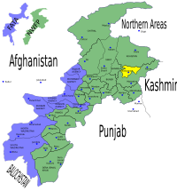
 Location of Battagram District (highlighted in yellow) | |
| Country | Pakistan |
| Province | Khyber Pakhtunkhwa |
| Capital | Battagram |
| Established | July 1993[citation needed] |
| Government | |
| • MNA | Qari Muhammad Yousuf (2013-Present) |
| Area | |
| • Total | 1,301 km2 (502 sq mi) |
| Elevation | 1,038 m (3,406 ft) |
| • Density | 236/km2 (610/sq mi) |
| Time zone | UTC5 (PST) |
| Zip/Postal Code | 21040 |
| Area code | 0997 |
| Number of Tehsils | 2 |
Battagram (Urdu: ضلع بٹگرام; Pashto: ضلع بټګرام) is a district in the Khyber Pakhtunkhwa province of Pakistan. It has a total land area of 1301 square kilometres.
Administration
Battagram obtained the status of district in July 1993 when it was upgraded from a Tehsil and separated from Mansehra District. Before Battagram obtained the status of district, it was a Tehsil of the Mansehra District. It has geographical borders with Kohistan District, the Tribal Area of Kala Dhaka (Black Mountain of Hazara), Shangla District and Malakand Division. The district consists of two sub-divisions or Tehsils, containing 20 in total. Union Councils:[1]
| Tehsil | No. of Unions | Name of Unions |
|---|---|---|
| Allai Tehsil | 8 | Banna, Bateela, Batkul, Biari, Jambera, Pashto, Rashang and Sakargah |
| Batagram Tehsil | 12 | Ajmera, Banian, Battagram, Batamori, Gijbori, Kuza Banda, Paimal Sharif, Peshora, Rajdhari, Shumlai, Thakot and Trand |
The district is represented in the provincial assembly by two MPAs from its constituencies PF-59 (Battagram-1) and PF-60 (Battagram-2).[2]
Earthquake 2005
Battagram was one of the areas affected by the Pakistan earthquake of October 8, 2005[3] when more than 4,500 people were killed and approximately 35,000 were injured. Many residents of the area were rendered homeless and without shelter. Since October 8, 2005, the NGOs and the governmental organization Earthquake Reconstruction and Rehabilitation Authority have been engaged in reconstruction work but as of 2009, the reconstruction work is not completed. In some cases residents have rebuilt houses themselves.
References
- ^ Tehsils & Unions in the District of Battagram – Government of Pakistan, NRB, archived from the original on 9 February 2012, retrieved 19 March 2012
{{citation}}: Unknown parameter|deadurl=ignored (|url-status=suggested) (help) - ^ Constituencies and MPAs – Website of the Provincial Assembly of the NWFP, PANWFP, archived from the original on 28 April 2008, retrieved 19 March 2012
{{citation}}: Unknown parameter|deadurl=ignored (|url-status=suggested) (help) - ^ Educational Institutes in Battagram, Hazara, retrieved 19 March 2012
External links
- BATTAGRAM-District Profile ERRA
- %22Chappargram%22&hl=en&gl=us&pid=bl&srcid=ADGEESjeb7GU1cZhB4hBOTw5QO4yzRYq2_4TetLI-Jbq3PBnrDtQCUqnaldyQJlyi6JkbsEAy7dniG5g40g6U5QZ4munxYKUOt5SzqS2QA5oCgSfh8Ig8Xwdr71fWtlbKWXiEs1PI1Zs&sig=AHIEtbTU5A-OcZVlflPbhTt4dREh40B9jA "List of polling stations" – The Gazette of Pakistan
- "NRC PAKISTAN EARTHQUAKE SITUATION REPORT – WEEK ENDING 5TH FEB 2006" – Norwegian Refugee Council

