Clay County, Kentucky
Clay County | |
|---|---|
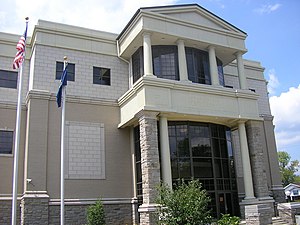
 Clay County courthouse in Manchester, Kentucky | |
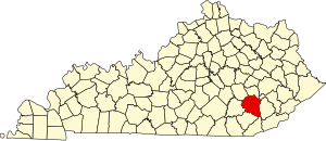
 Location within the U.S. state of Kentucky | |
 Kentucky's location within the U.S. | |
| Coordinates: 37°10′N 83°43′W / 37.16°N 83.71°W | |
| Country | |
| State | |
| Founded | 1807 |
| Named for | Green Clay (1757–1828), military general and surveyor. |
| Seat | Manchester |
| Area | |
| • Total | 471 sq mi (1,220 km2) |
| • Land | 471 sq mi (1,220 km2) |
| • Water | 0 sq mi (0 km2) 0.01% |
| Population (2000) | |
| • Total | 24,556 |
| • Density | 52/sq mi (20/km2) |
| Time zone | UTC−5 (Eastern) |
| • Summer (DST) | UTC−4 (EDT) |
Clay County is a county located in the U.S. state of Kentucky. It was formed in 1807. As of 2000, the population was 24,556. Its name is in honor of Green Clay (1757-1826). Clay was a member of the Virginia and Kentucky State legislatures, first cousin once removed of Henry Clay, U.S. Senator from Kentucky and Secretary of State in the 19th century. Its county seat is Manchester, Kentucky. The county is a prohibition or dry county.Template:GR
Geography
According to the U.S. Census Bureau, the county has a total area of 471 square miles (1,220 km²), of which, 471 square miles (1,220 km²) of it is land and 0 square miles (0 km²) of it (0.01%) is water. Coincidentally, the soil in the county has a high clay content.
Adjacent counties
- Owsley County (north)
- Perry County (northeast)
- Leslie County (east)
- Bell County (southeast)
- Knox County (southwest)
- Laurel County (west)
- Jackson County (northwest)
Demographics
| Census | Pop. | Note | %± |
|---|---|---|---|
| 1810 | 2,398 | — | |
| 1820 | 4,393 | 83.2% | |
| 1830 | 3,548 | −19.2% | |
| 1840 | 4,607 | 29.8% | |
| 1850 | 5,421 | 17.7% | |
| 1860 | 6,652 | 22.7% | |
| 1870 | 8,297 | 24.7% | |
| 1880 | 10,222 | 23.2% | |
| 1890 | 12,447 | 21.8% | |
| 1900 | 15,364 | 23.4% | |
| 1910 | 17,789 | 15.8% | |
| 1920 | 19,795 | 11.3% | |
| 1930 | 18,526 | −6.4% | |
| 1940 | 23,901 | 29.0% | |
| 1950 | 23,116 | −3.3% | |
| 1960 | 20,748 | −10.2% | |
| 1970 | 18,481 | −10.9% | |
| 1980 | 22,752 | 23.1% | |
| 1990 | 21,746 | −4.4% | |
| 2000 | 24,556 | 12.9% | |
| http://ukcc.uky.edu/~census/21051.txt | |||
As of the censusTemplate:GR of 2000, there were 24,556 people, 8,556 households, and 6,442 families residing in the county. The population density was 52 people per square mile (20/km²). There were 9,439 housing units at an average density of 20 per square mile (8/km²). The racial makeup of the county was 93.92% White, 4.80% Black or African American, 0.21% Native American, 0.12% Asian, 0.02% Pacific Islander, 0.23% from other races, and 0.71% from two or more races. 1.36% of the population were Hispanics or Latinos of any race.
There were 8,556 households out of which 36.90% had children under the age of 18 living with them, 58.60% were married couples living together, 12.40% had a female householder with no husband present, and 24.70% were non-families. 22.50% of all households were made up of individuals and 9.00% had someone living alone who was 65 years of age or older. The average household size was 2.62 and the average family size was 3.06.
The age distribution was 25.40% under the age of 18, 9.20% from 18 to 24, 32.60% from 25 to 44, 22.50% from 45 to 64, and 10.30% who were 65 years of age or older. The median age was 35 years. For every 100 females there were 111.70 males. For every 100 females age 18 and over, there were 112.60 males.
The median income for a household in the county was $16,271, and the median income for a family was $18,925. Males had a median income of $24,164 versus $17,816 for females. The per capita income for the county was $9,716. About 35.40% of families and 39.70% of the population were below the poverty line, including 47.60% of those under age 18 and 31.30% of those age 65 or over. The county's per-capita income makes it one of the poorest counties in the United States, and the poorest that is majority non-Hispanic white.
Presidential elections
The county has been solidly Republican for decades.[1] In the last 16 years the only Republican to receive less than 60% was Bob Dole, who still won the county by nearly 25%. In 2008 John McCain received 77.5% of the vote.[2]
Murder of census worker
In 2009, a census worker Bill Sparkman] was found dead, hanged from a tree with the word "fed" scrawled on his chest, after conducting door-to-door interviews in the area. A nearby sociology professor mentioned that he has not seen a display of anti-government sentiment here, as has been seen in other parts of the US.[3]

