
Palestine (region)
_showing_Israel%27s_1948_and_1967_borders.svg)
Palestine (Greek: Παλαιστίνη, Palaistinē; Latin: Palaestina; Hebrew: ארץ־ישראל Eretz-Yisra'el, formerly also פלשת, Peleshet; Arabic: فلسطين Filasṭīn, Falasṭīn, Filisṭīn) was a conventional name, among others, used between 450 BC and 1948 AD to describe the geographic region between the Mediterranean Sea and the Jordan River, and various adjoining lands.[1][2][3][4][5]
The boundaries of the region have changed throughout history, and were first defined in modern times by the Franco-British boundary agreement (1920) and the Transjordan memorandum during the British Mandate for Palestine. Today, the region comprises the country of Israel and the Palestinian territories.
Today, the term Palestine is also used to refer to either the Palestinian territories or the State of Palestine.
Other terms for the same area include Canaan, Zion, the Land of Israel, Syria Palaestina, Southern Syria, Jund Filastin, Outremer, the Holy Land and the Southern Levant.[6]
Etymology
The term Peleset (transliterated from hieroglyphs as P-r-s-t) is found in numerous Egyptian documents referring to a neighboring people or land starting from c.1150 BCE during the Twentieth dynasty of Egypt. The first mention is thought to be in texts of the temple at Medinet Habu which record a people called the Peleset among the Sea Peoples who invaded Egypt in Ramesses III's reign.[7] The Assyrians called the same region Palashtu or Pilistu, beginning with Adad-nirari III in the Nimrud Slab in c.800 BCE through to emperor Sargon II in his Annals approximately a century later.[8][9][10] Neither the Egyptian or Assyrian sources provided clear regional boundaries for the term.
The first clear use of the term Palestine to refer to the region synonymous with that defined in modern times was in 5th century BC Ancient Greece. Herodotus wrote of a 'district of Syria, called Palaistinê" in The Histories, the first historical work clearly defining the region, which included the Judean mountains and the Jordan Rift Valley.[11][12][13][14][15][16] Approximately a century later, Aristotle used a similar definition in Meteorology, writing "Again if, as is fabled, there is a lake in Palestine, such that if you bind a man or beast and throw it in it floats and does not sink, this would bear out what we have said. They say that this lake is so bitter and salt that no fish live in it and that if you soak clothes in it and shake them it cleans them," understood by scholars to be a reference to the Dead Sea.[17] Later writers such as Polemon and Pausanias also used the term to refer to the same region. This usage was followed by Roman writers such as Ovid, Tibullus, Pomponius Mela, Pliny the Elder, Dio Chrysostom, Statius, Plutarch as well as Roman Judean writers Philo of Alexandria and Josephus[18]. Other writers, such as Strabo, a prominent Roman-era geographer (although he wrote in Greek), referred to the region as Coele-Syria around 10-20 CE.[19][20] The term was first used to denote an official province in c.135 CE, when the Roman authorities, following the suppression of the Bar Kokhba Revolt, combined Iudaea Province with Galilee and other surrounding cities such as Ashkelon to form "Syria Palaestina" (Syria Palaestina), which some scholars state was in order to complete the dissociation with Judaea.[21][22]
The Hebrew name Peleshet (פלשת Pəlésheth)- usually translated as Philistia in English, is used in the Bible more than 250 times. In the Torah / Pentateuch the term is used 10 times and its boundaries are undefined. The later Historical books (see Deuteronomistic history) include most of the biblical references, almost 200 of which are in the Book of Judges and the Books of Samuel, where the term is used to denote the southern coastal region to the west of the ancient Kingdom of Judah.[23][8][9][18]
During the Byzantine period, the entire region (Syria Palestine, Samaria, and the Galilee) was named Palaestina, subdivided into provinces Palaestina I and II.[24] The Byzantines also renamed an area of land including the Negev, Sinai, and the west coast of the Arabian Peninsula as Palaestina Salutaris, sometimes called Palaestina III.[24] The Arabic word for Palestine is فلسطين (commonly transcribed in English as Filistin, Filastin, or Falastin).[25] Moshe Sharon writes that when the Arabs took over Greater Syria in the 7th century, place names that were in use by the Byzantine administration before them, generally continued to be used. Hence, he traces the emergence of the Arabic form Filastin to this adoption, with Arabic inflection, of Roman and Hebrew (Semitic) names.[8] Jacob Lassner and Selwyn Ilan Troen offer a different view, writing that Jund Filastin, the full name for the administrative province under the rule of the Arab caliphates, was traced by Muslim geographers back to the Philistines of the Bible.[26] The use of the name "Palestine" in English became more common after the European renaissance.[27] It was officially revived by the British after the fall of the Ottoman Empire and applied to the territory that was placed under The Palestine Mandate.
Some other terms that have been used to refer to all or part of this land include Canaan, Greater Israel, Greater Syria, the Holy Land, Iudaea Province, Judea,[28] Israel, "Israel HaShlema", Kingdom of Israel, Kingdom of Jerusalem, Land of Israel (Eretz Yisrael or Ha'aretz), Zion, Retenu (Ancient Egyptian), Southern Syria, and Syria Palestina.
History
Overview
Situated at a strategic location between Egypt, Syria and Arabia, and the birthplace of the Abrahamic religions, the region has a long and tumultuous history as a crossroads for religion, culture, commerce, and politics. The region has been controlled by numerous different peoples, including Ancient Egyptians, Canaanites, Ancient Israelites, Assyrians, Babylonians, Persians, Ancient Greeks, Romans, Byzantines, the Sunni Arab Caliphate, the Shia Fatimid Caliphate, Crusaders, Ayyubids, Mameluks, Ottomans, the British and modern Israelis and Palestinians. Modern archaeologists and historians of the region refer to their field of study as Syro-Palestinian archaeology.

Ancient period

The region was among the earliest in the world to see human habitation, agricultural communities and civilization. During the Bronze Age, independent Canaanite city-states were established, and were influenced by the surrounding civilizations of ancient Egypt, Mesopotamia, Phoenicia, Minoan Crete, and Syria. Between 1550-1400 BCE, the Canaanite cities became vassals to the Egyptian New Kingdom who held power until the 1178 BCE Battle of Djahy (Canaan) during the wider Bronze Age collapse. The Philistines arrived and mingled with the local population, and according to Biblical tradition, the United Kingdom of Israel was established in 1020 BC and split within a century to form the northern Kingdom of Israel, and the southern Kingdom of Judah. The region became part of the Neo-Assyrian Empire from c740 BCE, which was itself replaced by the Neo-Babylonian Empire in c.627 BCE. According to the bible, a war with Egypt culminated in 586 BCE when Jerusalem was destroyed by the Babylonian king Nebuchadnezzar II and the local leaders of the region of Judea were deported to Babylonia. In 539 BCE, the Babylonian empire was replaced by the Achaemenid Empire. According to the bible and implications from the Cyrus Cylinder, the exiled population of Judea was allowed to return to Jerusalem.
Classical antiquity

In the 330s BCE, Alexander the Great conquered the region, and the region changed hands numerous times during the wars of the Diadochi. ultimately joining the Seleucid Empire between 219-200 BCE. In 116 BCE, a Seleucid civil war resulted in the independence of certain regions including the minor Hasmonean principality in the Judean Mountains. From 110 BCE, the Hasmoneans extended their authority over much of Palestine, creating a Judean-Samaritan-Idumaean-Ituraean-Galilean alliance. The Judean (Jewish, see Ioudaioi) control over the wider region resulted in it also becoming known as Judaea, a term which had previously only referred to the smaller region of the Judean Mountains. Between 73-63 BCE, the Roman Republic extended its influence in to the region in the Third Mithridatic War, conquering of Judea in 63 BCE, and splitting the former Hasmonean Kingdom into five districts. The three year Ministry of Jesus, culminating in his crucifixion, is estimated to have occurred from 28-30 CE, although the historicity of Jesus is disputed by scholars. In 70 AD, Titus sacked Jerusalem, resulting in the dispersal of the city's Jews and Christians to Yavne and Pella. In 132 AD, Hadrian joined the province of Iudaea with Galilee to form new province of Syria Palaestina, and Jerusalem was renamed "Aelia Capitolina". Between 259-272, the region fell under the rule of Odaenathus as King of the Palmyrene Empire. Following the victory of Christian emperor Constantine in the Civil Wars of the Tetrarchy (306–324), the Christianization of the Roman Empire began, and in 326, Constantine's mother Saint Helena visited Jerusalem and began the construction of churches and shrines. Palestine became a center of Christianity, attracting numerous monks and religious scholars. The Samaritan Revolts during this period caused their near extinction. In 614 AD, Palestine was annexed by another Persian dynasty; the Sassanids, until returning to Byzantine control in 628 AD.[29]
Middle Ages

Palestine joined the Islamic Empire following at the 636 AD Battle of Yarmouk during the Muslim conquest of Syria. In 661 CE, with the assassination of Ali, Muawiyah I became the uncontested Caliph of the Islamic World after being crowned in Jerusalem. In 691, the Dome of the Rock became the world's first great work of Islamic architecture. The Umayyad were replaced by the Abbasids in 750. From 878 Palestine was ruled from Egypt by semi-autonomous rulers for almost a century, beginning with Ahmad ibn Tulun, and ending with the Ikhshidid rulers who were both buried in Jerusalem. The Fatimids conquered the region in 969. In 1073 Palestine was captured by the Great Seljuq Empire, only to be recaptured by the Fatimids in 1098, who then lost the region to the Crusaders in 1099. Their control of Jerusalem and most of Palestine lasted almost a century until defeat by Saladin's forces in 1187, after which most of Palestine was controlled by the Ayyubids. A rump crusader state in the northern coastal cities survived for another century, but, despite seven further crusades the crusaders was no longer a significant power in the region. The Mamluk Sultanate was indirectly created in Egypt as a result of the Seventh Crusade. The Mongol Empire reached Palestine for the first time in 1260, beginning with the Mongol raids into Palestine under Nestorian Christian general Kitbuqa and reaching an apex at the pivotal Battle of Ain Jalut. In 1486, hostilities broke out between the Mamluks and the Ottoman Turks in a battle for control over western Asia and the Ottomans captured Palestine in 1516.
Modern period

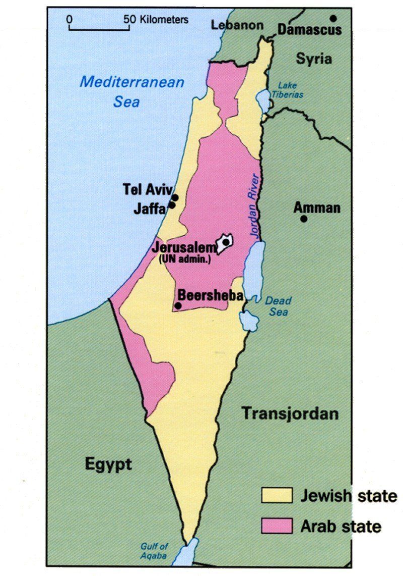
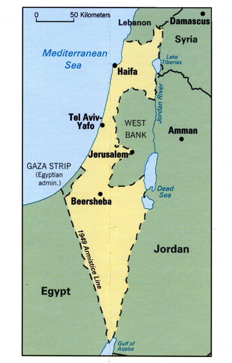
In 1832 Palestine was conquered by Muhammad Ali's Egypt, but in 1840 Britain intervened and returned control of the Levant to the Ottomans in return for further capitulations. The end of the 19th century saw the beginning of Zionist immigration and the Revival of the Hebrew language. The movement was publicly supported by Great Britain during World War I with the Balfour Declaration of 1917. The British captured Jerusalem a month later, and were formally awarded a mandate in 1922. The non-Jewish Palestinians revolted in 1920, 1929 and 1936. In 1947, following World War II and the Holocaust, the British Government announced their desire to terminate the Mandate, and the United Nations General Assembly voted to partition the territory into a Jewish state and an Arab state. The Jewish leadership accepted the proposal but the Arab Higher Committee rejected it; a civil war began immediately, and Israel was declared in 1948. The 700,000 Palestinians who fled or were driven from their homes were unable to return following the Lausanne Conference, 1949. In the 1948 Arab-Israeli War, Israel captured and incorporated a further 26% of the Mandate territory, Jordan captured the region today known as the West Bank and the Gaza Strip was captured by Egypt. In the course of the Six Day War in June 1967, Israel captured the rest of Mandate Palestine from Jordan and Egypt, and began a policy of Israeli settlements. From 1987 to 1993, the First Palestinian Intifada against Israel took place, ending with the 1993 Oslo Peace Accords. In 2000, the Second or Al-Aqsa Intifada began, and Israel built a security barrier. Following Israel's unilateral disengagement plan of 2004, it withdrew all settlers and most of the military presence from the Gaza strip, but maintained control of the air space and coast.
Boundaries
The boundaries of Palestine have varied throughout history.[30][31]
The boundaries of the land of the Philistines is not defined in the Torah / Pentateuch. However, according to the Deuteronomistic history of the Bible the Philistine confederation in circa 1185 BC comprised five city states: Gaza, Ashkelon, Ashdod on the coast and Ekron, and Gath inland.[10] Its northern border was the Yarkon River, the southern border extending to Wadi Gaza, its western border the Mediterranean Sea, with no fixed border to the east.[7]
The boundaries of the area and the ethnic nature of the people referred to by Herodotus in the 5th century BC as Palaestina vary according to context. Sometimes, he uses it to refer to the coast north of Mount Carmel. Elsewhere, distinguishing the Syrians in Palestine from the Phoenicians, he refers to their land as extending down all the coast from Phoenicia to Egypt.[32] Pliny, writing in Latin in the 1st century AD, describes a region of Syria that was "formerly called Palaestina" among the areas of the Eastern Mediterranean.[33]
Since the Byzantine Period, the Byzantine borders of Palaestina (I and II, also known as Palaestina Prima, "First Palestine", and Palaestina Secunda, "Second Palestine"), have served as a name for the geographic area between the Jordan River and the Mediterranean Sea. Under Arab rule, Filastin (or Jund Filastin) was used administratively to refer to what was under the Byzantines Palaestina Secunda (comprising Judaea and Samaria), while Palaestina Prima (comprising the Galilee region) was renamed Urdunn ("Jordan" or Jund al-Urdunn).[8]
The Zionist Organization provided their definition concerning the boundaries of Palestine in a statement to the Paris Peace Conference in 1919; it also includes a statement about the importance of water resources that the designated area includes.[34][35] On the basis of a League of Nations mandate, the British administered Palestine after World War I, promising to establish a Jewish homeland therein.[36] The original Mandate Palestine included what is now Israel, the West Bank (of the Jordan), and Transjordan (the present kingdom of Jordan), although the latter was disattached by an administrative decision of the British in 1922.[37] To the Palestinian people who view Palestine as their homeland, its boundaries are those of Mandate Palestine excluding the Transjordan, as described in the Palestinian National Charter.[38]
Demographics
Early demographics
Estimating the population of Palestine in antiquity relies on two methods – censuses and writings made at the times, and the scientific method based on excavations and statistical methods that consider the number of settlements at the particular age, area of each settlement, density factor for each settlement.
According to Magen Broshi, an Israeli archaeologist "... the population of Palestine in antiquity did not exceed a million persons. It can also be shown, moreover, that this was more or less the size of the population in the peak period—the late Byzantine period, around AD 600"[39] Similarly, a study by Yigal Shiloh of The Hebrew University suggests that the population of Palestine in the Iron Age could have never exceeded a million. He writes: "... the population of the country in the Roman-Byzantine period greatly exceeded that in the Iron Age...If we accept Broshi's population estimates, which appear to be confirmed by the results of recent research, it follows that the estimates for the population during the Iron Age must be set at a lower figure."[40]
Late Ottoman and British Mandate periods
In the middle of the 1st century of the Ottoman rule, i.e. 1550 AD, Bernard Lewis in a study of Ottoman registers of the early Ottoman Rule of Palestine reports:[41]
From the mass of detail in the registers, it is possible to extract something like a general picture of the economic life of the country in that period. Out of a total population of about 300,000 souls, between a fifth and a quarter lived in the six towns of Jerusalem, Gaza, Safed, Nablus, Ramle, and Hebron. The remainder consisted mainly of peasants, living in villages of varying size, and engaged in agriculture. Their main food-crops were wheat and barley in that order, supplemented by leguminous pulses, olives, fruit, and vegetables. In and around most of the towns there was a considerable number of vineyards, orchards, and vegetable gardens.
By Volney's estimates in 1785, there were no more than 200,000 people in the country.[42] According to Alexander Scholch, the population of Palestine in 1850 had about 350,000 inhabitants, 30% of whom lived in 13 towns; roughly 85% were Muslims, 11% were Christians and 4% Jews[43]
According to Ottoman statistics studied by Justin McCarthy,[44] the population of Palestine in the early 19th century was 350,000, in 1860 it was 411,000 and in 1900 about 600,000 of which 94% were Arabs. In 1914 Palestine had a population of 657,000 Muslim Arabs, 81,000 Christian Arabs, and 59,000 Jews.[45] McCarthy estimates the non-Jewish population of Palestine at 452,789 in 1882, 737,389 in 1914, 725,507 in 1922, 880,746 in 1931 and 1,339,763 in 1946.[46]
In 1920, the League of Nations' Interim Report on the Civil Administration of Palestine stated that there were 700,000 people living in Palestine:
Of these 235,000 live in the larger towns, 465,000 in the smaller towns and villages. Four-fifths of the whole population are Moslems. A small proportion of these are Bedouin Arabs; the remainder, although they speak Arabic and are termed Arabs, are largely of mixed race. Some 77,000 of the population are Christians, in large majority belonging to the Orthodox Church, and speaking Arabic. The minority are members of the Latin or of the Uniate Greek Catholic Church, or—a small number—are Protestants.
The Jewish element of the population numbers 76,000. Almost all have entered Palestine during the last 40 years. Prior to 1850 there were in the country only a handful of Jews. In the following 30 years a few hundreds came to Palestine. Most of them were animated by religious motives; they came to pray and to die in the Holy Land, and to be buried in its soil. After the persecutions in Russia forty years ago, the movement of the Jews to Palestine assumed larger proportions.[47]
By 1948, the population had risen to 1,900,000, of whom 68% were Arabs, and 32% were Jews (UNSCOP report, including bedouin).
Current demographics
According to Israel's Central Bureau of Statistics, as of May 2006, of Israel's 7 million people, 77% were Jews, 18.5% Arabs, and 4.3% "others".[48] Among Jews, 68% were Sabras (Israeli-born), mostly second- or third-generation Israelis, and the rest are olim — 22% from Europe,the former Soviet republics, Russia, and the Americas, and 10% from Asia and Africa, including the Arab countries.[49]
Of Israel's 7 million citizens, 516,569 Jewish ones live in enclaves referred to as Israeli settlements and outposts in various lands adjacent to the state of Israel occupied by Israel during the Six Day War.[50][51][52]
According to Palestinian evaluations, The West Bank is inhabited by approximately 2.4 million Palestinians and the Gaza Strip by another 1.4 million. According to a study presented at The Sixth Herzliya Conference on The Balance of Israel's National Security[53] there are 1.4 million Palestinians in the West Bank. This study was criticised by demographer Sergio DellaPergola, who estimated 3.33 million Palestinians in the West Bank and Gaza Strip combined at the end of 2005.[54]
According to these Israeli and Palestinian estimates, the population in Israel and the Palestinian Territories stands between 9.8 and 10.8 million.
Jordan has a population of around 6,000,000 (2007 estimate).[55][56] Long term Palestinian war refugees constitute approximately half of this number.[57]
See also
- Israeli-Palestinian conflict
- Names of the Levant
- Outline of the Palestinian territories
- Place names of Palestine
- Province of Judah ("Yehud Medinata")
References
- ^ "The Palestine Exploration Fund". The Palestine Exploration Fund. Retrieved 2008-04-04.
- ^ "Palestine:". JewishEncyclopedia.com. Retrieved 2011-09-15.
- ^ Pappe, Ilan (2006). A History of Modern Palestine: One Land, Two Peoples. Cambridge University Press. ISBN 0521683157. Retrieved 6 Feb 2011.
{{cite book}}: Cite has empty unknown parameter:|coauthors=(help) - ^ Kramer, Gudrun (2008). A History of Palestine: From the Ottoman Conquest to the Founding of the State of Israel. Princeton University Press. ISBN 0691118973. Retrieved 6 Feb 2011.
- ^ Ahlstrom, Gosta (1993). The History of Ancient Palestine. Augsburg Fortress Publishers. ISBN 0800627709. Retrieved 6 Feb 2011.
- ^ de Geus, 2003, p. 7.
- ^ a b Fahlbusch et al., 2005, p. 185.
- ^ a b c d Sharon, 1988, p. 4.
- ^ a b Room, 1997, p. 285.
- ^ a b Carl S. Ehrlich "Philistines" The Oxford Guide to People and Places of the Bible. Ed. Bruce M. Metzger and Michael D. Coogan. Oxford University Press, 2001.
- ^ Jacobson, David M., Palestine and Israel, Bulletin of the American Schools of Oriental Research, No. 313 (Feb., 1999), pp. 65–74
- ^ The Southern and Eastern Borders of Abar-Nahara Steven S. Tuell Bulletin of the American Schools of Oriental Research, No. 284 (Nov., 1991), pp. 51–57
- ^ Herodotus' Description of the East Mediterranean Coast Anson F. Rainey Bulletin of the American Schools of Oriental Research, No. 321 (Feb., 2001), pp. 57–63
- ^ In his work, Herodotus referred to the practice of male circumcision associated with the Hebrew people: "the Colchians, the Egyptians, and the Ethiopians, are the only nations who have practised circumcision from the earliest times. The Phoenicians and the Syrians of Palestine themselves confess that they learnt the custom of the Egyptians.... Now these are the only nations who use circumcision." The History of Herodotus
- ^ Beloe, W., Rev., Herodotus, (tr. from Greek), with notes, Vol.II, London, 1821, p.269 "It should be remembered that Syria is always regarded by Herodotus as synonymous with Assyria. What the Greeks called Palestine the Arabs call Falastin, which is the Philistines of Scripture."
- ^ Elyahu Green, Geographic names of places in Israel in Herodotos This is confirmed by George Rawlinson in the third book (Thalia) of The Histories where Palaestinian Syrians are part of the fifth tax district spanning the territory from Phoenicia to the borders of Egypt, but excludes the kingdom of Arabs who were exempt from tax for providing the Assyrian army with water on its march to Egypt. These people had a large city called Cadytis, identified as Jerusalem.
- ^ Meteorology By Aristotle
- ^ a b Robinson, Edward, Physical geography of the Holy Land, Crocker & Brewster, Boston, 1865, p.15. Robinson, writing in 1865 when travel by Europeans to the Ottoman Empire became common asserts that, "Palestine, or Palestina, now the most common name for the Holy Land, occurs three times in the English version of the Old Testament; and is there put for the Hebrew name פלשת, elsewhere rendered Philistia. As thus used, it refers strictly and only to the country of the Philistines, in the southwest corner of the land. So, too, in the Greek form, Παλαςτίνη), it is used by Josephus. But both Josephus and Philo apply the name to the whole land of the Hebrews ; and Greek and Roman writers employed it in the like extent."
- ^ Studies in Hellenistic Judaism :Louis H. Feldman
- ^ The Hellenistic settlements in Syria, the Red Sea Basin, and North Africa :Getzel M. Cohen
- ^ Lehmann, Clayton Miles (1998). "Palestine: History: 135–337: Syria Palaestina and the Tetrarchy". The On-line Encyclopedia of the Roman Provinces. University of South Dakota. Retrieved 2008-07-06.
{{cite web}}: Unknown parameter|month=ignored (help) - ^ Sharon, 1998, p. 4. According to Moshe Sharon: "Eager to obliterate the name of the rebellious Judaea", the Roman authorities (General Hadrian) renamed it Palaestina or Syria Palaestina.
- ^ Lewis, 1993, p. 153.
- ^ a b Kaegi, 1995, p. 41.
- ^ Marshall Cavendish, 2007, p. 559.
- ^ Lassner and Troen, 2007, pp. 54–55.
- ^ Gudrun Krämer (2008) A History of Palestine: From the Ottoman Conquest to the Founding of the State of Israel Translated by Gudrun Krämer and Graham Harman Princeton University Press, ISBN 0-691-11897-3 p 16
- ^ Judea[dead link]
- ^ Greatrex-Lieu(2002), II, 196
- ^ According to the Jewish Encyclopedia published between 1901 and 1906: "Palestine extends, from 31° to 33° 20′ N. latitude. Its southwest point (at Raphia = Tell Rifaḥ, southwest of Gaza) is about 34° 15′ E. longitude, and its northwest point (mouth of the Liṭani) is at 35° 15′ E. longitude, while the course of the Jordan reaches 35° 35′ to the east. The west-Jordan country has, consequently, a length of about 150 English miles from north to south, and a breadth of about 23 miles at the north and 80 miles at the south. The area of this region, as measured by the surveyors of the English Palestine Exploration Fund, is about 6,040 square miles. The east-Jordan district is now being surveyed by the German Palästina-Verein, and although the work is not yet completed, its area may be estimated at 4,000 square miles. This entire region, as stated above, was not occupied exclusively by the Israelites, for the plain along the coast in the south belonged to the Philistines, and that in the north to the Phoenicians, while in the east-Jordan country the Israelitic possessions never extended farther than the Arnon (Wadi al-Mujib) in the south, nor did the Israelites ever settle in the most northerly and easterly portions of the plain of Bashan. To-day the number of inhabitants does not exceed 650,000. Palestine, and especially the Israelitic state, covered, therefore, a very small area, approximating that of the state of Vermont." From the Jewish Encyclopedia Boundaries and Extent
- ^ According to the Encyclopædia Britannica Eleventh Edition (1911), [1] Palestine is:
- "[A] geographical name of rather loose application. Etymological strictness would require it to denote exclusively the narrow strip of coast-land once occupied by the Philistines, from whose name it is derived. It is, however, conventionally used as a name for the territory which, in the Old Testament, is claimed as the inheritance of the pre-exilic Hebrews; thus it may be said generally to denote the southern third of the province of Syria.
- Except in the west, where the country is bordered by the Mediterranean Sea, the limit of this territory cannot be laid down on the map as a definite line. The modern subdivisions under the jurisdiction of the Ottoman Empire are in no sense conterminous with those of antiquity, and hence do not afford a boundary by which Palestine can be separated exactly from the rest of Syria in the north, or from the Sinaitic and Arabian deserts in the south and east; nor are the records of ancient boundaries sufficiently full and definite to make possible the complete demarcation of the country. Even the convention above referred to is inexact: it includes the Philistine territory, claimed but never settled by the Hebrews, and excludes the outlying parts of the large area claimed in Num. xxxiv. as the Hebrew possession (from the " River of Egypt " to Hamath). However, the Hebrews themselves have preserved, in the proverbial expression " from Dan to Beersheba " (Judg. xx.i, &c.), an indication of the normal north-and-south limits of their land; and in defining the area of the country under discussion it is this indication which is generally followed.
- Taking as a guide the natural features most nearly corresponding to these outlying points, we may describe Palestine as the strip of land extending along the eastern shore of the Mediterranean Sea from the mouth of the Litany or Kasimiya River (33° 20' N.) southward to the mouth of the Wadi Ghuzza; the latter joins the sea in 31° 28' N., a short distance south of Gaza, and runs thence in a south-easterly direction so as to include on its northern side the site of Beersheba. Eastward there is no such definite border. The River Jordan, it is true, marks a line of delimitation between Western and Eastern Palestine; but it is practically impossible to say where the latter ends and the Arabian desert begins. Perhaps the line of the pilgrim road from Damascus to Mecca is the most convenient possible boundary. The total length of the region is about 140 m (459.32 ft); its breadth west of the Jordan ranges from about 23 m (75.46 ft) in the north to about 80 m (262.47 ft) in the south."
- ^ Herodotus, The Histories Bk.7.89
- ^ cf. Pliny, Natural History V.66 and 68.
- ^ "Zionist Organization Statement on Palestine, Paris Peace Conference, (February 3, 1919) The Boundaries of Palestine". Jewishvirtuallibrary.org. Retrieved 2010-08-24.
- ^ "Statement of the Zionist Organization Regarding Palestine Presented to the Paris Peace Conference (with proposed map of Zionist borders) February 3, 1919". Mideastweb.org. Retrieved 2010-08-24.
- ^ "Middle East Documents Balfour Declaration". Mideastweb.org. Retrieved 2009-06-16.
- ^ "The British Mandate for Palestine". Mideastweb.org. Retrieved 2009-06-16.
- ^ Said and Hitchens, 2001, p. 199.
- ^ Magen Broshi, The Population of Western Palestine in the Roman-Byzantine Period, Bulletin of the American Schools of Oriental Research, No. 236, p.7, 1979.
- ^ Yigal Shiloh, The Population of Iron Age Palestine in the Light of a Sample Analysis of Urban Plans, Areas, and Population Density, Bulletin of the American Schools of Oriental Research, No. 239, p.33, 1980.
- ^ Bernard Lewis, Studies in the Ottoman Archives—I, Bulletin of the School of Oriental and African Studies, University of London, Vol. 16, No. 3, pp. 469–501, 1954
- ^ Katz, 115 citing C.F.C Conte de Volney: Travels through Syria & Egypt in the years 1783, 1784, 1785 (London, 1798). Vol II p. 219
- ^ Scholch, 1985, p. 503.
- ^ McCarthy, 1990, p.26.
- ^ McCarthy, 1990.
- ^ McCarthy, 1990, pp. 37–38.
- ^ Interim Report on the Civil Administration of Palestine[dead link]
- ^ Central Bureau of Statistics, Government of Israel. "Population, by religion and population group" (PDF). Retrieved 2006-04-08.
- ^ Central Bureau of Statistics, Government of Israel. "Jews and others, by origin, continent of birth and period of immigration" (PDF). Retrieved 2006-04-08.
- ^ Israel Central Bureau of Statistics: [2] [3] [4]
- ^ Jerusalem Institute for Israel Studies: [5] [6] [7] [8]
- ^ Foundation for Middle East Peace: [9] [10].
- ^ Bennett Zimmerman & Roberta Seid (January 23, 2006). "Arab Population in the West Bank & Gaza: The Million Person Gap". American-Israel Demographic Research Group. Retrieved 2006-09-27.
- ^ Sergio DellaPergola (Winter 2007, No. 27). "Letter to the Editor". Azure. Archived from the original on 2007-09-27. Retrieved 2007-01-11.
{{cite web}}: Check date values in:|date=(help) - ^ Jordan: Facts & Figures, accessed 22 May 2007.
- ^ CIA World Factbook, accessed 22 May 2007.
- ^ Assessment for Palestinians in Jordan, Minorities at Risk, accessed 22 May 2007.
Bibliography
|
|
External links
This article's use of external links may not follow Wikipedia's policies or guidelines. (November 2010) |
- www.palestinecenter.org - A website with current and historical information about Palestine
- Palestine Royal Commission Report (the Peel Report) (London, 1937) Jewishvirtuallibrary.org
- www.mideastweb.org - A website with a wealth of statistics regarding population in Palestine
- Coins and Banknotes of Palestine under the British Mandate
- WorldStatesmen- Maps, flags, chronology, see Israel and Palestinian National Authority
- hWeb - Israel-Palestine in Maps
- Palestine Fact Sheet from the Common Language Project
- 1911 Encyclopedia description of Palestine
- Liberal Democrat Friends of Palestine
Maps
- Sykes-Picot Agreement, 1916
- 1947 UN Partition Plan
- 1949 Armisitice Lines
- Israel After 1949 Armistice Agreements


![[4]](http://www.cbs.gov.il/archive/shnaton47/st02-07.gif)
Palestine region articles | |||||||||
|---|---|---|---|---|---|---|---|---|---|
| History |  | ||||||||
|
| Regimes |
| ||||||||