
Kołobrzeg: Difference between revisions
Filling in 2 references using Reflinks |
|||
| Line 47: | Line 47: | ||
== History == |
== History == |
||
=== Early Middle Ages: Slavic Pomeranian stronghold === |
=== Early Middle Ages: Slavic Pomeranian stronghold === |
||
Kołobrzeg's official city website dates the town's existence to 5th and 6th century<ref name="Kalendarium">[http://serwis.kolobrzeg.eu/historia_kalendarium.htm] Historic calendar of the city's Official webpage </ref> and mentions a local [[Slavic]] [[gród]] which existed in the nearby area. The local Slavic population engaged in fishery, salt trade and various crafts and that in 10th century the trade of salt and fish led to the development of the settlement into a town.<ref name="Epoki">[http://serwis.kolobrzeg.eu/historia_epoki.htm] ‘Historical eras’ Official webpage of the city</ref> |
|||
Slavic immigration reached [[Farther Pomerania]] in the 7th century.<ref>Jan M Piskorski, Pommern im Wandel der Zeit, 1999, p.29 ISBN 839061848</ref><ref>Ole Harck, Christian Lübke, Zwischen Reric und Bornhöved: Die Beziehungen zwischen den Dänen und ihren slawischen Nachbarn vom 9. Bis ins 13. Jahrhundert: Beiträge einer internationalen Konferenz, Leipzig, 4.-6. Dezember 1997, Franz Steiner Verlag, 2001, p.15, ISBN 3515076719</ref> In the late 9th century, a [[Pomeranians (Slavic tribe)|Slavic Pomeranian]] stronghold was built at the site of modern [[Budzistowo]]<ref name=Schich>Winfried Schich, Ralf Gebuhr, Peter Neumeister, ''Wirtschaft und Kulturlandschaft: Gesammelte Beiträge 1977 bis 1999 zur Geschichte der Zisterzienser und der "[[Germania Slavica]]", BWV Verlag, 2007, p.280, ISBN 3830503784</ref> near modern Kołobrzeg,<ref name=Koebler341>Gerhard Köbler, ''Historisches Lexikon der Deutschen Länder: die deutschen Territorien vom Mittelalter bis zur Gegenwart'', 7th edition, C.H.Beck, 2007, p.341, ISBN 3406549861</ref> replacing nearby [[Bardy-Świelubie]], a multi-ethnic emporium, as the center of the region.<ref name=Harck1516>Ole Harck, Christian Lübke, Zwischen Reric und Bornhöved: Die Beziehungen zwischen den Dänen und ihren slawischen Nachbarn vom 9. Bis ins 13. Jahrhundert: Beiträge einer internationalen Konferenz, Leipzig, 4.-6. Dezember 1997, Franz Steiner Verlag, 2001, pp.15,16, ISBN 3515076719</ref> The [[Parseta]] valley, where both the emporium and the stronghold were located, was one of the [[Pomeranians (Slavic tribe)|Slavic Pomeranians]]' core settlement areas.<ref>Jörg Jarnut, Peter Johanek, ''Die Frühgeschichte der europäischen Stadt im 11. Jahrhundert'', Köln-Weimar-Wien 1998, pp.273-305, republished in Winfried Schich, Ralf Gebuhr, Peter Neumeister, ''Wirtschaft und Kulturlandschaft - Siedlung und Wirtschaft im Bereich der [[Germania Slavica]]'', BWV Verlag, 2007, p.263, ISBN 3830503784</ref> The stronghold consisted of a fortified [[burgh]] with a suburbium.<ref name=Mueller>Eckhard Müller-Mertens, Heidelore Böcker, ''Konzeptionelle Ansätze der Hanse-Historiographie'', Porta Alba, 2003, p.133, ISBN 3933701066</ref><ref>Jörg Jarnut, Peter Johanek, ''Die Frühgeschichte der europäischen Stadt im 11. Jahrhundert'', Köln-Weimar-Wien 1998, pp.273-305, republished in Winfried Schich, Ralf Gebuhr, Peter Neumeister, ''Wirtschaft und Kulturlandschaft - Siedlung und Wirtschaft im Bereich der [[Germania Slavica]]'', BWV Verlag, 2007, p.277, ISBN 3830503784</ref> |
Slavic immigration reached [[Farther Pomerania]] in the 7th century.<ref>Jan M Piskorski, Pommern im Wandel der Zeit, 1999, p.29 ISBN 839061848</ref><ref>Ole Harck, Christian Lübke, Zwischen Reric und Bornhöved: Die Beziehungen zwischen den Dänen und ihren slawischen Nachbarn vom 9. Bis ins 13. Jahrhundert: Beiträge einer internationalen Konferenz, Leipzig, 4.-6. Dezember 1997, Franz Steiner Verlag, 2001, p.15, ISBN 3515076719</ref> In the late 9th century, a [[Pomeranians (Slavic tribe)|Slavic Pomeranian]] stronghold was built at the site of modern [[Budzistowo]]<ref name=Schich>Winfried Schich, Ralf Gebuhr, Peter Neumeister, ''Wirtschaft und Kulturlandschaft: Gesammelte Beiträge 1977 bis 1999 zur Geschichte der Zisterzienser und der "[[Germania Slavica]]", BWV Verlag, 2007, p.280, ISBN 3830503784</ref> near modern Kołobrzeg,<ref name=Koebler341>Gerhard Köbler, ''Historisches Lexikon der Deutschen Länder: die deutschen Territorien vom Mittelalter bis zur Gegenwart'', 7th edition, C.H.Beck, 2007, p.341, ISBN 3406549861</ref> replacing nearby [[Bardy-Świelubie]], a multi-ethnic emporium, as the center of the region.<ref name=Harck1516>Ole Harck, Christian Lübke, Zwischen Reric und Bornhöved: Die Beziehungen zwischen den Dänen und ihren slawischen Nachbarn vom 9. Bis ins 13. Jahrhundert: Beiträge einer internationalen Konferenz, Leipzig, 4.-6. Dezember 1997, Franz Steiner Verlag, 2001, pp.15,16, ISBN 3515076719</ref> The [[Parseta]] valley, where both the emporium and the stronghold were located, was one of the [[Pomeranians (Slavic tribe)|Slavic Pomeranians]]' core settlement areas.<ref>Jörg Jarnut, Peter Johanek, ''Die Frühgeschichte der europäischen Stadt im 11. Jahrhundert'', Köln-Weimar-Wien 1998, pp.273-305, republished in Winfried Schich, Ralf Gebuhr, Peter Neumeister, ''Wirtschaft und Kulturlandschaft - Siedlung und Wirtschaft im Bereich der [[Germania Slavica]]'', BWV Verlag, 2007, p.263, ISBN 3830503784</ref> The stronghold consisted of a fortified [[burgh]] with a suburbium.<ref name=Mueller>Eckhard Müller-Mertens, Heidelore Böcker, ''Konzeptionelle Ansätze der Hanse-Historiographie'', Porta Alba, 2003, p.133, ISBN 3933701066</ref><ref>Jörg Jarnut, Peter Johanek, ''Die Frühgeschichte der europäischen Stadt im 11. Jahrhundert'', Köln-Weimar-Wien 1998, pp.273-305, republished in Winfried Schich, Ralf Gebuhr, Peter Neumeister, ''Wirtschaft und Kulturlandschaft - Siedlung und Wirtschaft im Bereich der [[Germania Slavica]]'', BWV Verlag, 2007, p.277, ISBN 3830503784</ref> |
||
Revision as of 07:42, 10 July 2009
Kołobrzeg | |
|---|---|
 Town center | |
 Coat of arms | |
| Country | |
| Voivodeship | West Pomeranian |
| County | Kołobrzeg County |
| Gmina | Kołobrzeg (urban gmina) |
| Established | 10th century |
| Town rights | 1255 |
| Government | |
| • Mayor | Janusz Gromek |
| Area | |
| • Total | 25.67 km2 (9.91 sq mi) |
| Population (2006) | |
| • Total | 44,794 |
| • Density | 1,700/km2 (4,500/sq mi) |
| Time zone | UTC+1 (CET) |
| • Summer (DST) | UTC+2 (CEST) |
| Postal code | 78-100 to 78-106 |
| Area code | +48 94 |
| Car plates | ZKL |
| Website | http://www.kolobrzeg.pl |
Kołobrzeg Template:Audio-IPA-pl (German: Kolberg ⓘ; Kashubian: Kòłobrzeg; Latin: Cholbergensis) is a city in Middle Pomerania in north-western Poland with some 50,000 inhabitants (as of 2000). Kołobrzeg is located on the Parsęta River on the south coast of the Baltic Sea (in the middle of the section divided by the Oder and Vistula Rivers). It has been the capital of Kołobrzeg County in West Pomeranian Voivodship since 1999, and previously was in Koszalin Voivodship (1950-1998).
The name of the town was first mentioned by Thietmar of Merseburg as Salsa Cholbergiensis. It was re-founded during the High Middle Ages, taking its position as the regional center from a nearby Slavic Pomeranian stronghold at the site of modern Budzistowo.[1][2][3] As a Hanseatic town chartered with Lübeck law, the town, known as Colberg, later spelling Kolberg, was the urban center of the secular reign of the Cammin bishops and their residence throughout the High and Late Middle Ages. When Kolberg was part of Brandenburgian Pomerania during the Early Modern Age, it withstood Napoleon's troops in the Siege of Kolberg. From 1815, it was part of the Prussian province of Pomerania. In 1945 the town became Polish and the Germans were expelled. The town, devastated in the preceding Battle of Kolberg, was rebuilt but lost its status as the regional center to nearby Koszalin.
Etymology
"Kołobrzeg" literally means "by the shore" in Polish: "koło" translates as "by"[4] and "brzeg" translates as "shore".[5] Polish historians declare its original name came from the words "kół" and "brzeg", meaning a settlement surrounded by wooden defensive wall, and was later Germanised into "Kolberg".[6] German sources state that the name was given by Germans and meant to describe a borough (Burg originally which became -berg) near the dunes.[citation needed]
History
Early Middle Ages: Slavic Pomeranian stronghold
Slavic immigration reached Farther Pomerania in the 7th century.[7][8] In the late 9th century, a Slavic Pomeranian stronghold was built at the site of modern Budzistowo[2] near modern Kołobrzeg,[9] replacing nearby Bardy-Świelubie, a multi-ethnic emporium, as the center of the region.[10] The Parseta valley, where both the emporium and the stronghold were located, was one of the Slavic Pomeranians' core settlement areas.[11] The stronghold consisted of a fortified burgh with a suburbium.[1][12]
The Pomeranians mined salt[13] in salt pans located in two downstream hills, Salzberg and Zillenberg.[14] They also engaged in fishing, and used the salt to conserve primarily herrings for trade.[15] Other important occupations were metallurgy and smithery, based on local iron ore reserves, other crafts like the production of combs from horn, and in the surrounding areas, agriculture.[16] Important sites in the settlement were a place for periodical markets and a tavern, mentioned as forum et taberna in 1140.[13]
In the 9th and 10th centuries, the burgh was the largest of several smaller ones in the Persante area, and as such is thought to have functioned as the center of the local Slavic Pomeranian subtribe.[16] By the turn from the 10th to the 11th century, the smaller burghs in the Parseta area were given up.[16] Only two burghs remained and underwent an enlargement, these were the burghs near the later towns of Kolobrzeg and Białogard.[16] St. John's was in 1222 granted to Mogilno Abbey, while St. Petri's decayed before 1300.[13]
Piast Poland and conversion

After the Polish conquest of the area in the late 10th century, the chronicle of Thietmar of Merseburg (975-1018) mentions salsa Cholbergiensis as the see of the Diocese of Kolberg, set up during the Congress of Gniezno in 1000 and placed under the Archdiocese of Gniezno.[9] The congress was organized by Polish king Bolesław Chrobry and Holy Roman Emperor Otto III, and also led to the establishment of bishoprics in Kraków and Wrocław, connecting the territories of the Polish state.[17]
The missionary efforts of bishop Reinbern were not successful, the Pomeranians revolted in 1005 and regained political and spiritual independence.[18][19][20][21] In 1013 Bolesław Chrobry removed his troops from Pomerania in face of war with Holy Roman Emperor Henry the Third.[22] The Polish - German war ended with Polish victory, which was confirmed by the 1018 Peace of Bautzen.
During his campaigns in the early 12th century, Bolesław III Wrymouth reacquired Pomerania for Poland, and made the local "Griffin" dynasty his vassals. The stronghold was captured by the Polish army in the winter of 1107/08, when the inhabitants (cives et oppidani) including a duke (dux Pomeranorum) surrendered without resistance.[23] A previous Polish siege of the burgh had been unsuccessful; although the duke had fled the burgh, the Polish army was unable to break through the fortifications and the two gates.[24] The army had however looted and burned the suburbium, which was not or only lightly fortified.[24] The descriptions given by the contemporary chroniclers make it possible that a second, purely militarily used castle existed near the settlement, yet neither is this certain nor have archaeological efforts been able to locate traces thereof.[25]
During the subsequent Christianization of the area by Otto of Bamberg, a St. Mary's church was built.[2] With this the German influence grew in strength.[17] After Boleslaw's death, the Duchy of Pomerania regained independence,[26] before the dukes became vassals of Denmark and the Holy Roman Empire in the late 12th century.
Besides St. Mary's , a St. John's church and a St. Petri's chapel were build.[13]
High and Late Middle Ages: A new town

During the Ostsiedlung, a new town was founded by German settlers some kilometers off the site of the former Slavic burgh.[3][27][28] On May 23, 1255, this town was chartered under Lübeck law by Wartislaw III, Duke of Pomerania,[29][30] and more German settlers from the Holy Roman Empire arrived, attracted by the duke.[27] Hermann von Gleichen, German bishop of the Roman Catholic Diocese of Kammin, was one of the signatories of the treaty and also supported the German colonisation of the region.[17] The German settlers received several privileges such as exemption from certain taxes.[17] According to the city's website, the local Slavic population was unable to compete economically with the German arrivals and impoverished.[17]
A new St. Mary's church was built within the new town before the 1260s,[31] while St. Mary's in the former Pomeranian stronghold was turned into a nuns' abbey.[2] Henceforth, the name "Kolberg" (earlier German spelling Colberg) was used for the German town[30] exclusively, while the nearby former stronghold was turned into a village and renamed "Old Town" or "Old Kolberg" (Latin: antiqua civitatae Colbergensis, German: Altstadt or Alt-Kolberg), first documented in 1277 and used until 1945 when it was renamed "Budzistowo".[1][2]

Already in 1248, the Kammin bishops and the Pomeranian dukes had interchanged the terrae Stargard and Kolberg, leaving the bishops in charge of the latter.[32] When in 1276 they became the souvereign of the town also, they moved their residence there, while the administration of the diocese was done from nearby Köslin (also Cöslin, now Koszalin).[32] In 1345, the bishops became Imperial immediate dukes in their secular reign.[32]
In 1361, Kolberg joined the Hanseatic League.
When the property of the Roman Catholic Diocese of Kammin was secularized during the Protestant Reformation in 1534, their secular reign including the Kolberg area became intermediately ruled by a Lutheran titular bishop, before it was turned into a Sekundogenitur of the House of Pomerania.[32]
In XV century the city traded with Scotland, Amsterdam and Scandinavia.[17] Beer,salt, honey, wool and flour were exported, while merchants imported textiles from England, southern fruits, and cod liver oil. In XVI century, the city reached 5 thousand inhabitants.[17] According to the city's website, the Slavs in the city were discriminated, and their rights in trade and crafts were limited, with bans on performing certain types of professions and taking certain positions[17]
Modern era: In Prussia

Kolberg with most of Farther Pomerania was granted to Brandenburg-Prussia in the 1648 Treaty of Westphalia, and since the Treaty of Stettin (1653) was part of the Province of Pomerania, becoming part of the Kingdom of Prussia in 1701. In 1761 the town was captured by the Russian commander Peter Rumyantsev during the Seven Years' War, but at the end of the war it was returned to Prussia.
During Napoleon's invasion of Prussia during the War of the Fourth Coalition, the town was besieged by French armies from April 26 to July 2, 1807. The city's defense, led by then Lieutenant-Colonel August von Gneisenau, held out until the war was ended by the Treaty of Tilsit. Kolberg became part of the Prussian Province of Pomerania in 1815 after the final defeat of Napoleon. Until 1872 it was administered within the Fürstenthum District ("Principality District", resembling the area's former special status), after which it was within Kolberg-Körlin.
Between 1924 and 1935 the American-German painter Lyonel Feininger, a tutor at the Staatliches Bauhaus, visited Kolberg repeatedly and painted the cathedral and environs of the town.
Polish diaspora
In the late 19th century Kolberg became a popular seaside resort and spa town among tourists from all over Germany with an amount of about 5 - 8 percent of Poles. Initially throughout the season, after about 1890 all the year, Polish masses were held in the Catholic Church of Kolberg[34] and during the period 1875-1914 an active Polish diaspora grew. Through its funds a Catholic school and the Church of Saint Marcin where masses in Polish were held, were established.[22][35]
World War II: Destruction
Historical population
of Kołobrzeg
| 1940 | 36,800 | |
| 1945 | 3,000 | |
| 1950 | 6,800 | |
| 1960 | 16,700 | |
| 1970 | 26,000 | |
| 1975 | 31,800 | |
| 1980 | 38,200 | |
| 1990 | 45,400 | |
| 1995 | 47,000 | |
| 2000 | ~50,000 | |
| 2002 | 47.500 | |
| 2004 | 45.500 | |
| 2006 | 44.000 |
In 1944 during World War II, the city was designated a "stronghold" (Festung) — Festung Kolberg. The 1807 siege was used shortly before the end of the war by Joseph Goebbels for the last Nazi propaganda film, Kolberg. It was meant to inspire the Germans with its depiction of the heroic Prussian defence during the Napoleonic Wars. Tremendous resources were devoted to filming this epic, even diverting tens of thousands of troops from the front lines to have them serve as extras in battle scenes. Ironically, the film was released in the final few weeks of Nazi Germany's existence, when most of the country's cinemas were already destroyed.
On 1945 February 10 German torpedo-boat T-196 brought to Kolberg about 300 survivors of the General von Steuben, which had been sunk by Soviet submarine S-13. As the Red Army advanced on Kolberg, most of the inhabitants and tens of thousands of refugees from surrounding areas (about 70,000 were trapped in the Kolberg Pocket), as well as 40,000 German soldiers, were evacuated from the besieged city by German naval forces in Operation Hannibal. Only about two-thousand soldiers were left on 17 March to cover last sea transports.
Between 4 March and 18 March 1945, there were major battles between the Soviet and Polish forces and the German army. Because of a lack of anti-tank weapons, German battleships used their guns to support the defenders of Kolberg until nearly all of the soldiers and civilians had been evacuated. On 18 March, the Polish Army re-enacted Poland's Wedding to the Sea ceremony, which had been celebrated for the first time in 1920 by General Józef Haller.
- Before, during, and after the war
-
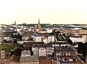 Kolberg between 1890 and 1905
 -
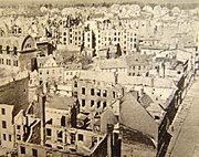 80% of Kolberg destroyed in 1945
 -
Rebuilt Kolobrzeg in 2007


Post-war Polish town
After World War II, the devastated city along with all of Pomerania east of the Oder-Neisse line became Polish, and the remaining German either fled or were expelled. The city was resettled with Poles, many of whom had themselves been expelled from Kresy, and historic buildings restored.
Millennium Memorial

In 2000 the city business council of Kolobrzeg commissioned "The Millennium Memorial" as a commemoration of 1000 years of Christianity in Pomerania, and as a tribute to Polish-German Reconciliation, celebrating the meeting of King Boleslaw I of Poland and King Otto III of Germany, at the Congress of Gniezno, in the year 1000.
It was designed and built by the artist Wiktor Szostalo in welded stainless steel. The two figures sit at the base of 15' tall cross, cleft in two and being held together by a dove holding an olive branch. It is installed outside the Basilica Cathedral in the city center.
Tourist destination

Kołobrzeg today is a popular tourist destination for both Poles and the Germans. It provides a unique combination of a seaside resort, health resort, an old town full of historic monuments and tourist entertainment options (e.g. numerous "beer gardens").
The town is part of the European Route of Brick Gothic[36] network, and located at a seaside bike path, the longest in Poland, commissioned on July 14, 2004. The path extends from Kołobrzeg to Podczele. It provides unique views of woods, beaches, swamps, impenetrable thickets, bird nesting grounds, and more. The path has been financed by the European Union.
An international airport was planned to be built 7 kilometres from Kołobrzeg in Bagicz. However, due to the protests of local population, the project has been scrapped.
South of Bagicz, some 4 km from Kolobrzeg, there is an 806 year old oak (2008). Dated in the year 2000 as the oldest oak in Poland, it was named Boleslaw to commemorate the king Boleslaus the Brave.
Kołobrzeg is also a regional cultural center. In the summer take place - a number of concerts of popular singers, musicians,and cabaters. Municipal Cultural Center, is located in the town hall. Keep under attachment artistic arts, theater and dance. Patron of youth teams and the vocal choir. Interfolk organizes the annual festival, the International Meeting of the folklore and other cultural events. Cinema is a place for meetings Piast Discussion Film Club.
In Kolobrzeg are many permanent and temporary exhibitions of artistic and historical interest. In the town hall of Kolobrzeg is located Gallery of Modern Art, where exhibitions are exposed artists from Kolobrzeg, as well as outside the local artistic circles. Gallery also conducts educational activities, including organized by the gallery of art lessons for children and young people from schools.
In town, there is a museum of Polish weapons, which are presented in the collections of militaria from the early Middle Ages to the present. The palace of Braunschweig include part of museum dedicated to the history of the city. In their collections branch presents a collection of rare and common measurement tools, as well as specific measures of the workshop. The local museum is also moored at the port of ORP Fala patrol ship, built in 1964, after leaving the service transformed into a museum.
Notable residents
- Johannes Colberg (1623–1687), Lutheran theologian
- Martin von Rango (1634–1688), Ratsherr (councilman), historian
- Konrad Tiburtius Rango (1639–1700), theologian, botanist
- Karl Wilhelm Ramler (1725-1798), poet, translator, director at Berlin theater
- Joachim Nettelbeck (1738–1824), seaman, representative during occupation of Kolberg 1807
- Christian Wilhelm Gericke (1748–1803), pietist, evangelical missionary
- Hermann Freihold Plüddemann (1809–1868), artist, illustrator
- Martin Plüddemann (1854–1897), componist, musical conductor
- Ernst Maass (1856–1929), classical philologian
- Magnus Hirschfeld (1868-1935), physician,sociologist and early 20th century Gay rights campaigner
- Hans Benzmann (1869–1926), lyricist
- Alfred Uckeley (1874–1955), evangelical theologian
- Paul Oestreich (1878-1959 ), educator, reformer
- Hans-Jürgen Stumpff (1889-1968), German general of Luftwaffe, co-signer of unconditional surrender 8 May 1945 in Berlin
- Karl Hans Janke (1909–1988), engineer, inventor, artist
- Erika von Brockdorff (1911-1943), German resistance fighter
- Dietwulf Baatz (* 1928), archaeologist
- Egon Krenz (* 1937), last Communist leader of East Germany.
- Wichart von Roëll (* 1937), actor
- Buzz Bütow (1943–2004), cartoonist, graphic-designer, film- and literature reviewer
- Agnieszka Rylik, boxing world champion (see: http://pl.wikipedia.org/wiki/Agnieszka_Rylik)
- Agata Stefanowicz (born 1978), humanitarian
- Dariusz Trafas (born 1972), athlete, javelin throw national record holder
- Robert Szpak (born 1989), athlete, javelin throw, 2008 World Junior Champion <http://pl.wikipedia.org/wiki/Robert_Szpak>
Famous Persons connected with the city
- Friedrich Ludwig Jahn, (1778-1852) Turnvater Jahn father of gymnastics, was banned at the city for five years [citation needed]
- Adolf von Lützow, (1782-1834) officer, received Pour le Mérite-order for protecting Kolberg against Napoléon Bonaparte troops[citation needed].
- Hermann Hirschfeld (* 1825; † 17. Juni 1885, physician, father of Magnus Hirschfeld. Was instrumental in establishing the town as a Baltic Sea spa resort[citation needed].
- Hans Heinrich von Held was banned to the city[citation needed]. Wrote its history and Über das Meerbad bei Colberg und die beste und wohlfeilste Art sich desselben mit Nutzen zu bedienen[citation needed].
- Paul Hinz, (born 1899) 1930-1945 pastor.Member of opposition against Third Reich. Saved treasures of Kolberg Dome[citation needed].
- Lyonel Feininger American-German artist, painted at between 1924 and 1935[citation needed]
External links
- Municipal website Template:Pl icon, Template:De icon and Template:En icon
- A Few Views of the prewar Kołobrzeg (then Kolberg) in Old Postcards
- History of the town on the tourist promotion site Template:En icon
54°11′N 15°35′E / 54.183°N 15.583°E
References
- ^ a b c Eckhard Müller-Mertens, Heidelore Böcker, Konzeptionelle Ansätze der Hanse-Historiographie, Porta Alba, 2003, p.133, ISBN 3933701066
- ^ a b c d e Winfried Schich, Ralf Gebuhr, Peter Neumeister, Wirtschaft und Kulturlandschaft: Gesammelte Beiträge 1977 bis 1999 zur Geschichte der Zisterzienser und der "Germania Slavica", BWV Verlag, 2007, p.280, ISBN 3830503784
- ^ a b Werner Buchholz, Pommern, Siedler, 1999, p.75, ISBN 3886802728
- ^ ADIPS Sp. z o.o. "DICT - English Polish Dictionary". Dict.pl. Retrieved 2009-07-08.
- ^ ADIPS Sp. z o.o. "DICT - English Polish Dictionary". Dict.pl. Retrieved 2009-07-08.
- ^ Kolobrzeg.pl municipal website
- ^ Jan M Piskorski, Pommern im Wandel der Zeit, 1999, p.29 ISBN 839061848
- ^ Ole Harck, Christian Lübke, Zwischen Reric und Bornhöved: Die Beziehungen zwischen den Dänen und ihren slawischen Nachbarn vom 9. Bis ins 13. Jahrhundert: Beiträge einer internationalen Konferenz, Leipzig, 4.-6. Dezember 1997, Franz Steiner Verlag, 2001, p.15, ISBN 3515076719
- ^ a b Gerhard Köbler, Historisches Lexikon der Deutschen Länder: die deutschen Territorien vom Mittelalter bis zur Gegenwart, 7th edition, C.H.Beck, 2007, p.341, ISBN 3406549861
- ^ Ole Harck, Christian Lübke, Zwischen Reric und Bornhöved: Die Beziehungen zwischen den Dänen und ihren slawischen Nachbarn vom 9. Bis ins 13. Jahrhundert: Beiträge einer internationalen Konferenz, Leipzig, 4.-6. Dezember 1997, Franz Steiner Verlag, 2001, pp.15,16, ISBN 3515076719
- ^ Jörg Jarnut, Peter Johanek, Die Frühgeschichte der europäischen Stadt im 11. Jahrhundert, Köln-Weimar-Wien 1998, pp.273-305, republished in Winfried Schich, Ralf Gebuhr, Peter Neumeister, Wirtschaft und Kulturlandschaft - Siedlung und Wirtschaft im Bereich der Germania Slavica, BWV Verlag, 2007, p.263, ISBN 3830503784
- ^ Jörg Jarnut, Peter Johanek, Die Frühgeschichte der europäischen Stadt im 11. Jahrhundert, Köln-Weimar-Wien 1998, pp.273-305, republished in Winfried Schich, Ralf Gebuhr, Peter Neumeister, Wirtschaft und Kulturlandschaft - Siedlung und Wirtschaft im Bereich der Germania Slavica, BWV Verlag, 2007, p.277, ISBN 3830503784
- ^ a b c d Jörg Jarnut, Peter Johanek, Die Frühgeschichte der europäischen Stadt im 11. Jahrhundert, Köln-Weimar-Wien 1998, pp.273-305, republished in Winfried Schich, Ralf Gebuhr, Peter Neumeister, Wirtschaft und Kulturlandschaft - Siedlung und Wirtschaft im Bereich der Germania Slavica, BWV Verlag, 2007, p.282, ISBN 3830503784
- ^ Jörg Jarnut, Peter Johanek, Die Frühgeschichte der europäischen Stadt im 11. Jahrhundert, Köln-Weimar-Wien 1998, pp.273-305, republished in Winfried Schich, Ralf Gebuhr, Peter Neumeister, Wirtschaft und Kulturlandschaft - Siedlung und Wirtschaft im Bereich der Germania Slavica, BWV Verlag, 2007, p.278, ISBN 3830503784
- ^ Jörg Jarnut, Peter Johanek, Die Frühgeschichte der europäischen Stadt im 11. Jahrhundert, Köln-Weimar-Wien 1998, pp.273-305, republished in Winfried Schich, Ralf Gebuhr, Peter Neumeister, Wirtschaft und Kulturlandschaft - Siedlung und Wirtschaft im Bereich der Germania Slavica, BWV Verlag, 2007, p.274, ISBN 3830503784
- ^ a b c d Jörg Jarnut, Peter Johanek, Die Frühgeschichte der europäischen Stadt im 11. Jahrhundert, Köln-Weimar-Wien 1998, pp.273-305, republished in Winfried Schich, Ralf Gebuhr, Peter Neumeister, Wirtschaft und Kulturlandschaft - Siedlung und Wirtschaft im Bereich der Germania Slavica, BWV Verlag, 2007, p.289, ISBN 3830503784
- ^ a b c d e f g h Cite error: The named reference
Epokiwas invoked but never defined (see the help page). - ^ Nora Berend, Christianization and the Rise of Christian Monarchy: Scandinavia, Central Europe and Rus' C. 900-1200, Cambridge University Press, 2007, p.293, ISBN 0521876168, 9780521876162
- ^ David Warner, Ottonian Germany: The Chronicon of Thietmar of Merseburg, Manchester University Press, 2001, p.358, ISBN 0719049261, 9780719049262
- ^ Michael Borgolte, Benjamin Scheller, Polen und Deutschland vor 1000 Jahren: Die Berliner Tagung über den"akt von Gnesen", Akademie Verlag, 2002, p.282, ISBN 3050037490, 9783050037493
- ^ Michael Müller-Wille, Rom und Byzanz im Norden: Mission und Glaubenswechsel im Ostseeraum während des 8.-14. Jahrhunderts: internationale Fachkonferenz der deutschen Forschungsgemeinschaft in Verbindung mit der Akademie der Wissenschaften und der Literatur, Mainz: Kiel, 18.-25. 9. 1994, 1997, p.105, ISBN 3515074988, 9783515074988
- ^ a b Cite error: The named reference
Kalendariumwas invoked but never defined (see the help page). - ^ Jörg Jarnut, Peter Johanek, Die Frühgeschichte der europäischen Stadt im 11. Jahrhundert, Köln-Weimar-Wien 1998, pp.273-305, republished in Winfried Schich, Ralf Gebuhr, Peter Neumeister, Wirtschaft und Kulturlandschaft - Siedlung und Wirtschaft im Bereich der Germania Slavica, BWV Verlag, 2007, p.275, ISBN 3830503784
- ^ a b Jörg Jarnut, Peter Johanek, Die Frühgeschichte der europäischen Stadt im 11. Jahrhundert, Köln-Weimar-Wien 1998, pp.273-305, republished in Winfried Schich, Ralf Gebuhr, Peter Neumeister, Wirtschaft und Kulturlandschaft - Siedlung und Wirtschaft im Bereich der Germania Slavica, BWV Verlag, 2007, pp.273-274, ISBN 3830503784
- ^ Jörg Jarnut, Peter Johanek, Die Frühgeschichte der europäischen Stadt im 11. Jahrhundert, Köln-Weimar-Wien 1998, pp.273-305, republished in Winfried Schich, Ralf Gebuhr, Peter Neumeister, Wirtschaft und Kulturlandschaft - Siedlung und Wirtschaft im Bereich der Germania Slavica, BWV Verlag, 2007, pp.274 ff, ISBN 3830503784
- ^ Joachim Herrmann, Die Slawen in Deutschland, Akademie-Verlag Berlin, 1985, pp.386
- ^ a b Sebastian Brather, Archäologie der westlichen Slawen: Siedlung, Wirtschaft und Gesellschaft im früh- und hochmittelalterlichen Ostmitteleuropa, Walter de Gruyter, 2001, p.156, ISBN 3110170612
- ^ Torsten Kempke in Ole Harck, Christian Lübke, Zwischen Reric und Bornhöved: die Beziehungen zwischen den Dänen und ihren slawischen Nachbarn vom 9. bis ins 13. Jahrhundert : Beiträge einer internationalen Konferenz, Leipzig, 4.-6. Dezember 1997, Franz Steiner Verlag, 2001, p.16, ISBN 3515076719
- ^ Copy of the charter (in Latin), printed in Heinrich Gottfried Philipp Gengler, Codex juris Municipalis Germaniae Medii Aevi: Regesten und Urkunden zur Verfassungs- und Rechtsgeschichte der deutschen Städte im Mittelalter, F. Enke, 1863, p.609, free view
- ^ a b Gerhard Köbler, Historisches Lexikon der Deutschen Länder: die deutschen Territorien vom Mittelalter bis zur Gegenwart, 7th edition, C.H.Beck, 2007, p.341, ISBN 3406549861:"1255 erhielt die deutsche Siedlung nördlich der slawischen Siedlung Stadtrect von Lübeck."
- ^ Jörg Jarnut, Peter Johanek, Die Frühgeschichte der europäischen Stadt im 11. Jahrhundert, Köln-Weimar-Wien 1998, pp.273-305, republished in Winfried Schich, Ralf Gebuhr, Peter Neumeister, Wirtschaft und Kulturlandschaft - Siedlung und Wirtschaft im Bereich der Germania Slavica, BWV Verlag, 2007, p.280, ISBN 3830503784
- ^ a b c d Gerhard Köbler, Historisches Lexikon der Deutschen Länder: die deutschen Territorien vom Mittelalter bis zur Gegenwart, 7th edition, C.H.Beck, 2007, p.113, ISBN 3406549861
- ^ Hillert Ibbeken, Karl Friedrich Schinkel, Elke Blauert, Martina Abri, Karl Friedrich Schinkel: Das architektonische Werk heute, 2nd edition, 2002, p.324, ISBN 3932565258
- ^ Peter Jancke: "Kolberg, Führer durch eine untergegangene Stadt", Husum 2008, ISBN-13: 978-3898763653
- ^ ‘’Związki Pomorza Zachodniego z Polską’’ page 100 Szymon Pałkowski, Wyższa Szkoła Inżynierska w Koszalinie 1996
- ^ "Europäische Route der Backsteingotik | Homepage". EuRoB. Retrieved 2009-05-05.
| Seat |
|  |
|---|---|---|
| Other gminas | ||
