
Red Rock Canyon National Conservation Area
| Red Rock Canyon National Conservation Area | |
|---|---|
IUCN category V (protected landscape/seascape) | |
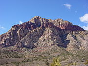
 Red Rock Canyon National Conservation Area view. | |
 | |
| Location | Clark County, Nevada, US |
| Nearest city | Las Vegas, Nevada |
| Coordinates | 36°08′08″N 115°25′38″W / 36.135574°N 115.42724°W |
| Area | 197,349 acres (798.64 km2)[1] |
| Established | 1967 |
| Visitors | 2,000,000+ |
| Governing body | Bureau of Land Management |
The Red Rock Canyon National Conservation Area in Clark County, Nevada, is an area managed by the Bureau of Land Management as part of its National Landscape Conservation System, and protected as a National Conservation Area. It is about 15 miles (24 km) west of Las Vegas, and is easily seen from the Las Vegas Strip. More than two million people visit the area each year.[2]
The conservation area showcases a set of large red rock formations: a set of sandstone peaks and walls called the Keystone Thrust. The walls are up to 3,000 feet (910 m) high, making them a popular hiking and rock climbing destination. The highest point is La Madre Mountain, at 8,154 feet (2,485 m).
A one-way loop road, 13 miles (21 km) long, provides vehicle access to many of the features in the area. Several side roads and parking areas allow access to many of the area trails. A visitor center is at the start of the loop road. The loop road is also popular for bicycle touring; it begins with a moderate climb, then is mostly downhill or flat.
Red Rock Canyon is a side-canyon accessible only by an unmaintained primitive road from the scenic loop which mostly only off-road or high clearance vehicles can access. State Route 159 cuts through an unnamed but often-visited valley; it is commonly, but mistakenly, referred to as Red Rock Canyon. The Wilson Cliffs, or Keystone Thrust, a massive wall of rock, can be seen to the west from SR 159.
Toward the southern end of the National Conservation Area are Spring Mountain Ranch State Park; Bonnie Springs Ranch, which includes a replica of a western ghost town; and the village of Blue Diamond.
History
Native Americans


The first humans were attracted to the Red Rock area due to its resources of water, plant, and animal life that could not be easily found in the surrounding desert. Hunters and gatherers such as the historical Southern Paiute and the much older Archaic, or Desert Culture Native Americans, have successively occupied this area.[3]
As many as six different Native American cultures may have been present at Red Rock over the millennia. The following chronology is an approximation, from the present to ancient pre-history:
- Southern Paiute- 900 to modern times
- Patayan Culture - 900 to early historic times in the 1800s
- Anasazi - 1 AD to 1150.
- Pinto/Gypsum- (Archaic) 3500 BC to 1 AD.
- San Dieguito - 7000 to 5500 BC.
- Paleo-Indians (Tule Springs)- 11,000 to 8000 BC.
Numerous petroglyphs, as well as pottery fragments, remain today throughout the area. In addition, several roasting pits used by the early Native Americans at Red Rock provide further evidence of human activity in the past.
Modern history
In the early 20th century, around the time the first European Americans settled in nearby Las Vegas, the Excelsior Company operated a small sandstone quarry near the northern area of the scenic loop. It proved to be uneconomical and was shut down. Evidence of the quarry's existence includes some of the huge sandstone blocks that have been left behind.
The Red Rocks have been a film location for such movies as Roy Rogers and his horse Trigger in Bells of San Angelo (1947) and was a location for The Stalking Moon with Gregory Peck in 1968.[4]
In 1967, the Bureau of Land Management designated 10,000 acres (16 sq mi; 40 km2) as the Red Rock Recreation Lands. By 1990, special legislation changed the status of the Red Rock Recreation Lands to a National Conservation Area, a status that also provides funds to maintain and protect it.[5]
The Howard Hughes Corporation, developer of Summerlin, has transferred land adjacent to the protected area, to provide a buffer between development and the conservation area. On the west side, Red Rock Canyon National Conservation Area is adjacent to the Spring Mountains National Recreation Area.
Biology

The conservation area is one of the easternmost parts of the Mojave Desert; the lowest elevation of the area, from 3,600 to 4,500 feet (1,100 to 1,400 m), is in the Lower Sonoran Zone, while the area from 4,500 feet (1,400 m) up is in the Upper Sonoran Zone. The character of the sandstone layers is such that a number of year-round springs may be found in the recesses of the side canyons.
Some 600 species of plants are known in the area. Common types in the valley floor include the Joshua tree, Mojave yucca, banana yucca, creosote, and blackbrush. Higher up the Utah juniper and Sonoran scrub oak[6] (also called scrub live oak)[7] come to dominate. Agave is easy to spot in red rock niches, with its thick low leaves and flowering stem that reaches twice the height of a man. The Calico Tanks trail has a plaque about prehistoric agave roasting pits. Ponderosa pines may be found at the top of the valley, where it connects to the Spring Mountains.
Wild burros are a familiar sight, as are rabbits and ground squirrels. Desert bighorn sheep are occasionally seen at higher elevations. During rare spring and summer rainstorms, tiny red-spotted toads can be seen emerging from pools of water.
The Conservation Area is protected habitat for the desert tortoise. A habitat at the Visitor Center houses eight females and two males.
Climate
| Climate data for Spring Mountain Ranch State Park, Nevada (Elevation 3,870ft) | |||||||||||||
|---|---|---|---|---|---|---|---|---|---|---|---|---|---|
| Month | Jan | Feb | Mar | Apr | May | Jun | Jul | Aug | Sep | Oct | Nov | Dec | Year |
| Record high °F (°C) | 71 (22) |
81 (27) |
86 (30) |
91 (33) |
103 (39) |
114 (46) |
111 (44) |
108 (42) |
102 (39) |
97 (36) |
82 (28) |
73 (23) |
114 (46) |
| Mean daily maximum °F (°C) | 53.0 (11.7) |
56.8 (13.8) |
63.7 (17.6) |
71.0 (21.7) |
80.3 (26.8) |
91.2 (32.9) |
96.7 (35.9) |
94.8 (34.9) |
87.7 (30.9) |
76.1 (24.5) |
62.1 (16.7) |
53.4 (11.9) |
73.9 (23.3) |
| Mean daily minimum °F (°C) | 29.7 (−1.3) |
32.9 (0.5) |
38.4 (3.6) |
44.3 (6.8) |
52.9 (11.6) |
63.6 (17.6) |
70.7 (21.5) |
68.5 (20.3) |
59.3 (15.2) |
47.3 (8.5) |
35.9 (2.2) |
29.5 (−1.4) |
47.8 (8.8) |
| Record low °F (°C) | 0 (−18) |
0 (−18) |
21 (−6) |
19 (−7) |
28 (−2) |
38 (3) |
45 (7) |
45 (7) |
32 (0) |
26 (−3) |
16 (−9) |
3 (−16) |
0 (−18) |
| Average precipitation inches (mm) | 1.78 (45) |
2.21 (56) |
1.88 (48) |
0.59 (15) |
0.24 (6.1) |
0.10 (2.5) |
0.99 (25) |
1.09 (28) |
0.56 (14) |
0.52 (13) |
0.75 (19) |
0.92 (23) |
11.64 (296) |
| Average snowfall inches (cm) | 0.8 (2.0) |
0.7 (1.8) |
0.3 (0.76) |
0.1 (0.25) |
0 (0) |
0 (0) |
0 (0) |
0 (0) |
0 (0) |
0 (0) |
0.1 (0.25) |
0.7 (1.8) |
2.6 (6.6) |
| Source: The Western Regional Climate Center[8] | |||||||||||||
Geology

The Red Rock area has a complex geological history, which over millions of years, helped create the region's dramatic landscape.
The Red Rock area was under an ocean basin during the Paleozoic Era 600 million years ago. Up to 9,000 feet (2,700 m) of limey sediments were deposited and eventually lithified to limestone.[9] During the Mesozoic Era 250 million years ago, the earth's crust started to rise due to tectonic shifts, and marine shales and sandstones were deposited. As the basin became isolated evaporite formations of salt and gypsum were deposited. Oxidation of the iron minerals in the sediments resulted in the red colors of some of the rocks. Deposition by streams and in swamp environments resulted in the formation of petrified wood in the area.[9]
By 180 million years ago, the climate continued to change and the area became a desert with vast expanses of huge shifting sand dunes. These dunes accumulated over a broad area, up to 0.5 miles (0.80 km) thick, and were lithified, cemented with calcium carbonate and iron oxides. They developed as the colorful Aztec Sandstone.[9]
During a mountain-building period called the Laramide orogeny around 66 million years ago, the Keystone Thrust Fault developed. The Keystone is part of a series of thrust faults which ran through much of western North America and through the Red Rock Conservation Area.[10] The movement of this fault forced the older gray sedimentary rock over the younger red rocks, forming the varicolored landscape that can be seen in the mountain today. The thrust is exposed over a distance of 13 miles (21 km) along the Red Rock escarpment.[9]
The Lee Canyon thrust plate may contain over 4,000 ft (1,200 m) of terrigenous rocks at the base. The Wheeler Pass thrust may contain at least 11,000 ft (3,300 m) of these rocks as well.[10]
Activities

Red Rock provides a wide variety of activities, the most popular being hiking, biking, rock scrambling, and rock climbing. Horseback riding and camping are also allowed on specific trails and in designated areas. Automobile and motorcycle clubs often conduct group drives through the 13-mile scenic drive. ATV use is not permitted in the area.
Aside from the obvious dangers from climbing rock faces and cliffs, visitors are informed that temperatures can routinely exceed 105 °F (41 °C) in the summer, so they must bring plenty of water. Visitors hiking into the backcountry off established trails are advised against traveling alone, and should inform other people of their plans. Risks include the presence of venomous rattlesnakes and flash flooding/lightning from thunderstorms.
Rock climbing
Although the Yosemite-size walls offer a host of challenging lines, technical climbing activity was not recorded before 1968. The first modern routes, climbed in the early 1970s, are described in several books.[11][12] The rock is Aztec Sandstone, a relatively solid variety with a hard surface varnish. Many climbs involve ascents of single crack systems hundreds of feet long.
The climbs of Red Rock cover a broad range of length and difficulty. The long, easy routes had made the area a common climbing training ground, but the canyon also offers many difficult climbs as well. In recent decades, this broad appeal and the classic nature of many routes has made the area an international destination for rock climbers.
Popular sport climbing areas include the Calico Hills and Sandstone Quarry. Red Rock has a multitude of traditional climbing areas, including single-pitch areas such as Brass Wall and Necromancer Wall, along with multi-pitch areas such as Eagle Wall, Aeolian Wall, Mescalito, and Solar Slab. Long free and big-wall aid routes are found on features such as the Rainbow Wall, first climbed over three days in 1973 by Joe Herbst and Larry Hamilton.
Hiking

Red Rock has hiking trails. There is a hiking trail map here. There are also picnic areas. Trails are changed and diverted depending upon the needs of the ecosystem. In early spring, depending upon the precipitation, waterfalls may be seen on the edge of the canyons. Popular trails within the vicinity of the scenic drive loop include:[13]
- Moenkopi Loop: Open country trail with Triassic fossils and desert flora. Begins at the visitor center, west of weather monitoring station. There are panoramic view of Wilson Cliffs. Trails connecting to the Calico Hills area. Difficulty: easy. Distance: 2 miles (3.2 km) (loop).
- Calico Hills: Runs along base of Calico Rocks, through Calico Basin, to Sandstone Quarry. Accessible from either Calico parking areas. Side trail runs to fee booth parking lot. Difficulty: easy to moderate. Distance: variable (depends on access point).
- Calico Tanks: Trail heads north, from Sandstone Quarry, and meets Turtlehead Peak Trail. Trail runs up a side canyon and rock terraces finally ending at a large natural water tank. Difficulty: moderately strenuous (rock scrambling and route finding skills recommended). Distance: 2.5 miles (4.0 km) round trip.
- Turtlehead Peak: From Sandstone Quarry, this trail runs north, then continues along the northwest side of the actual Turtlehead Peak. Difficulty: very strenuous. Distance: 5 miles (8.0 km) round trip.
- Keystone Thrust: From the upper White Rocks Springs parking lot, the trail runs north. This trail then branches off from the La Madre Springs loop, joins an old jeep road, and continues uphill to the left. Views include the Keystone Thrust Fault where gray limestone meets red and tan sandstone. Difficulty: moderate. Distance: 2.2 miles (3.5 km) round trip.
- White Rock to Willow Springs: From the White Rock Springs upper parking lot, the rail runs west and splits to the right down to a man made water hole (guzzler). The trail goes downhill, through a wash, up a ridge, arriving at the Lost Creek area, then Willow Springs. Difficulty: easy to moderate. Distance: 4.4 miles (7.1 km) round trip.
- White Rock/La Made Springs Loop: Accessible from either White Rock Springs or Willow Springs, and can be done going either direction. Difficulty: moderate. Distance: 6 miles (9.7 km) round trip.
- Lost Creek Children's Discovery Trail: Beginning at the Lost Creek parking area, the trail intersects with Willow Springs loop and shares it until the split at Site #3. Continue on the loop, past Site #4, where another path leads to a seasonal waterfall. Difficulty: easy. Distance: .7 miles (1.1 km) round trip.
- Willow Springs Loop: From the parking lot, the trail runs south. Views of a pictograph site and Agave roasting pits can be seen. Passing the Lost Creek parking lot, the rail runs right, past Site #3, and on to the Willow Springs Parking Lot. Difficulty: easy. Distance: 1.5 miles (2.4 km) miles round trip.
- La Madre Springs: Beginning at the Willow Springs parking lot, take the dirt road west and up the canyon. After crossing a wash, veer right at the split, continue uphill to a dam, follow the trail to the springs. Difficulty: moderate. Distance: 3 miles (4.8 km) round trip.
- Smyc Trail: Accessible from the Lost Creek or Ice Box Trail, this one runs at the base of the escarpment and connects both trails. Difficulty: moderate. Distance: 2.2 miles (3.5 km) round trip.
- Ice Box Canyon: The trail begins at the parking lot, goes across a wash and toward the canyon, this portion is well defined. It then drops down the canyon, where routing around or over boulders may be required. A ponderosa tree can be found at the official end of the trail but an upper pool filled with seasonal waterfall can be found .25 miles (0.40 km) further. Difficulty: moderately strenuous. Distance: 2.5 miles (4.0 km).
- Dale's Trail: This trail can be accessed from either Ice Box Trail or Pine Creek Trail. It follows the terrain at the base of the escarpment and connects the two above mentioned trails. Difficulty: moderate. Distance: (4.4 miles (7.1 km) round trip)
- Pine Creek Canyon: From the parking lot, the trail runs downhill toward the canyon. The trail does get intersected at two points by Fire Ecology Trail and Dale's Trail, then forks near Old Wilson homestead foundation. The trail runs left, goes downhill, crosses a stream, then uphill toward an intersection with Arnight Trail. After crossing a wash, the main trail will reemerge on the opposite side of the homestead. Difficulty: moderate. Distance: 2.9 miles (4.7 km) round trip.
- Fire Ecology Trail: The entrance and exit to this trail are accessed from the Pine Creek Trail. The trail runs left toward the escarpment, over a bridge and rise, then the second loop is entered. Return across the same bridge. Difficulty: easy. Distance: .75 miles (1.21 km) round trip.
- Oak Creek Canyon Trail: This trail originates at the Oak Creek turnoff from the scenic drive loop, there is a parking lot available there. The trail begins in open desert and heads toward the mouth of Oak Creek Canyon. Difficulty: easy. Distance: 2 miles (3.2 km) round trip.
- Arnight Trail: From the parking lot, the trail runs toward the escarpment, is intersected by Knoll Trail, then joins Pink Creek Trail just above the loop junction. Difficulty: moderate. Distance: 2.4 miles (3.9 km) round trip.
- Knoll Trail: This trail follows the base of the escarpment and connects with First Creek Trail. Difficulty: easy to moderate. Distance: 1.9 miles (3.1 km) one-way. A hike on this trail can be connected with Oak Creek and Arnight Trails for an increase of distance to 3.5 miles (5.6 km) round trip and difficulty increases to moderate.
- First Creek Canyon Trail: This trail begins off Charleston Blvd., or State Route 159, 2.6 miles (4.2 km) miles south of the scenic loop. It heads toward the mouth of the canyon, down the left side, then over boulders. Seasonal waterfalls can be seen within the canyon. Difficulty: moderately strenuous. Distance: 2.5 miles (4.0 km) round trip.
- Grand Circle Adventure: Originating at the fee booth parking area, this trail runs across several other trails. It heads toward Calico Hills Trail, onto Sandstone Quarry, the White Rock Springs parking lot, down the hill toward Willow Springs, passes over a ridge and across scenic loop drive, then downhill toward the visitor center. Difficulty: strenuous. Distance: 11 miles (18 km) miles round trip.
- Escarpment Base Trail: This trail combines SMYC, Dale's, and Arnight trails. It can be accessed from the Lost Creek or Oak Creek parking areas, run one-way or round trip. Difficulty: moderate to strenuous. Distance: 5.2 miles (8.4 km) miles one-way (car pool or shuttle required), 10.4 miles (16.7 km) miles round trip.
- Overlook Trail: A paved path leads up a small hill behind a helicopter pad. Views of Red Rock Canyon and the escarpment can be seen. Difficulty: easy (wheelchair accessible). Distance: .25 miles (0.40 km) round trip.
- Bridge Mountain Trail: Accessible from the summit of Rocky Gap Road. Difficulty: challenging. Off-road/4x4 required.
Wildfire history
Several significant wildfires have burned within the Red Rock Canyon NCA in recent years, including:
- 1998 - A fire occurred in the loop area. By 2003, regrowth has made it difficult to find the burn area.[citation needed]
- June 25, 2005 - The Goodsprings fire consumed more than 31,600 acres (49.4 sq mi; 128 km2), burning into Red Rock NCA's southern area.[citation needed]
- July 22, 2005 - Lightning caused an 800-acre (1.3 sq mi; 3.2 km2) fire in the loop area.[citation needed]
- September 6, 2006 - Another fire was started by lightning in the loop near the visitor's center and burned around 1,500 acres (2.3 sq mi; 6.1 km2).[citation needed]
- July 2013 - The Carpenter I fire. Burned mainly in the Spring Mountains National Recreation Area, but encroached on the northwest portion of Red Rock Canyon National Conservation Area. It can be easily viewed[when?] from SR 157 Kyle Canyon Road. Caused by lightning in Trout Canyon nearby.[14][15]
Damage caused by wildfires, as well as evidence of the ability of the desert to heal itself over time,[vague] is visible from the loop road.[citation needed]
Recent fires seem to have been in part[according to whom?] fueled by the thick growth of invasive species red brome and cheat grasses. The Bureau of Land Management has not[as of?] developed plans to control these species, because control methods — like using herbicides — can be both costly economically and damaging to native plants.[16]
Gallery
-
 Red Rock welcome sign
 -
 Wild burros at RRNCA
 -
 Joshua tree with Calico Hills in the background
 -
 Outcrop of the Aztec Sandstone (Lower Jurassic) showing distorted eolian sand beds
 -
 Calico Hills
 -
-
 Calico basin
 -
 Spring wildflowers in RRCNCA
 -
 Winter scene with snow in RRCNCA


.jpg)


See also
Notes
- ^ "Welcome to Red Rock Canyon National Conservation Area". Bureau of Land Management. Archived from the original on 2011-09-02. Retrieved 2011-09-03.
- ^ "Red Rock Canyon National Conservation Area". Bureau of Land Management. Bureau of Land Management. Retrieved 3 June 2017.
- ^ "Red Rock Cultural Resources". Bureau of Land Management. Retrieved 2011-09-03.
- ^ BLM list of film locations, 2015
- ^ "Red Rock Canyon National Conservation Area Overview". GORP. Retrieved 2011-09-03.
- ^ USDA, NRCS (n.d.). "Quercus turbinella". The PLANTS Database (plants.usda.gov). Greensboro, North Carolina: National Plant Data Team.
- ^ "Shrub Live Oak (Quercus turbinella)". birdandhike.com. Retrieved 2011-09-03.
- ^ "Seasonal Temperature and Precipitation Information". Western Regional Climate Center. Retrieved November 17, 2013.
- ^ a b c d "Red Rock Geology". Bureau of Land Management. Retrieved 2011-09-03.
- ^ a b Burchfiel, B. C.; Fleck, R. J.; Secor, D. T.; Vincelette, R. R.; Davis, G. A. (1974-07-01). "Geology of the Spring Mountains, Nevada". Geological Society of America Bulletin. 85 (7): 1013–1022. doi:10.1130/0016-7606(1974)85<1013:gotsmn>2.0.co;2. ISSN 0016-7606.
- ^ DeAngelo, L. (2004). "Red Rock Odyssey". www.verexpress.com.
{{cite web}}: Missing or empty|url=(help) - ^ Handren, Jerry (2016). Red Rocks: A Climber’s Guide (2 ed.). Las Vegas.
{{cite book}}: CS1 maint: location missing publisher (link) - ^ "Red Rock Canyon Hiking". www.blm.gov. 2016-10-20. Retrieved 2017-02-25.
 This article incorporates text from this source, which is in the public domain.
- ^ "Press Release, Bureau of Land Management".
- ^ "Notice of Temporary Area Closure at the rEd Rock Canyon National Conservation Area due to Carpenter", Federal Register, 24 September 2014
- ^ Rogers, Keith (2006-09-08). "Officials see long road to recovery for desert plants". Las Vegas Review-Journal. Retrieved 2011-09-03.
References

- Urioste, Joanne, The Red Rocks of Southern Nevada, American Alpine Club, 1984 ISBN 978-0-930410-17-9
- Clinesmith, Larry L. and Elsie L. Sellars, Red Rock Canyon Plants, Red Rock Canyon Interpretive Association, 2001 ISBN 978-0-9707179-0-0
- Handren, Jerry, Red Rocks Climber's Guide II, 2016 ISBN 978-1-4951-8204-4
External links
![]() Media related to Red Rock Canyon National Conservation Area at Wikimedia Commons
Media related to Red Rock Canyon National Conservation Area at Wikimedia Commons
- Flowers of RRCNCA by BLM
| LV Transportation | |||||||
|---|---|---|---|---|---|---|---|
| Arts and museums |
| ||||||
| Sports | |||||||
| Government | |||||||
| Communities |
| ||||||
| Research and education | |||||||
| Parks and public spaces |
| ||||||
| Area shopping |
| ||||||
| Other | |||||||
- IUCN Category V
- Spring Mountains
- Canyons and gorges of Nevada
- Landforms of Clark County, Nevada
- Protected areas of Clark County, Nevada
- Bike paths in Nevada
- Tourist attractions in the Las Vegas Valley
- Climbing areas of Nevada
- Geologic formations with imbedded sand dunes
- Protected areas of the Mojave Desert
- Protected areas of Nevada
- National Conservation Areas of the United States
- Bureau of Land Management areas in Nevada
- Units of the National Landscape Conservation System
- Badlands of the United States