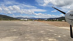
Juvai Semaring Airport
Appearance
Juvai Semaring Airport Bandar Udara Juvai Semaring | |||||||||||
|---|---|---|---|---|---|---|---|---|---|---|---|
 | |||||||||||
| Summary | |||||||||||
| Airport type | Public | ||||||||||
| Serves | Long Bawan, North Kalimantan, Indonesia | ||||||||||
| Elevation AMSL | 762 m / 2,500 ft | ||||||||||
| Coordinates | 03°54′11.2″N 115°41′31.2″E / 3.903111°N 115.692000°E | ||||||||||
| Map | |||||||||||
 | |||||||||||
| Runways | |||||||||||
| |||||||||||
Juvai Semaring Airport (Indonesian: Bandar Udara Juvai Semaring[1]) (IATA: LBW, ICAO: WAQJ previously WRLB) is an airport serving Long Bawan, located in the province of North Kalimantan in Indonesia.[2] It is also known as Long Bawan Airport.
Facilities
The airport resides at an elevation of 762 metres (2,500 ft) above mean sea level. It has one runway designated 04/22 which measures 900 by 30 metres (2,953 ft × 98 ft).[1]
Airlines and destinations
| Airlines | Destinations |
|---|---|
| Suzi Air, MAF | Malinau, Nunukan, Tarakan[3] |
References
- ^ a b c "Yuvai Semaring (LBW / WAQJ)". Directorate General of Civil Aviation, Ministry of Transportation, Republic of Indonesia. Retrieved 6 June 2010.
- ^ a b Airport information for Long Bawan, East Kalimantan, Indonesia - Juvai Semaring (WRLB / LBW) at Great Circle Mapper.
- ^ "Archived copy". Archived from the original on 2012-06-20. Retrieved 2012-06-23.
{{cite web}}: CS1 maint: archived copy as title (link)

