Fitzpatrick Wilderness
| Fitzpatrick Wilderness | |
|---|---|
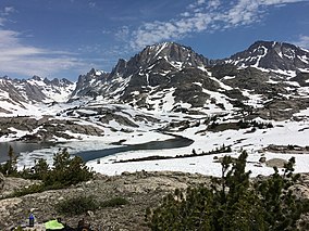
 Fremont Peak (Wyoming) in the Wind River Range near the Fitzpatrick Wilderness | |
| Location | Fremont / Sublette counties, Wyoming, United States |
| Nearest city | Lander, WY |
| Coordinates | 43°12′N 109°38′W / 43.200°N 109.633°W |
| Area | 198,525 acres (803.40 km2) |
| Established | 1976 |
| Governing body | U.S. Forest Service |
The Fitzpatrick Wilderness is located in Shoshone National Forest in the U.S. state of Wyoming. The wilderness was originally known as the Glacier Primitive Area, but was redesignated a wilderness in 1976.
Overview
U.S. Wilderness Areas do not allow motorized or mechanized vehicles, including bicycles. Although camping and fishing are allowed with proper permit, no roads or buildings are constructed and there is also no logging or mining, in compliance with the 1964 Wilderness Act. Wilderness areas within National Forests and Bureau of Land Management areas also allow hunting in season.
Hazards
Encountering bears is a concern in the Wind River Range, as well as in this nearby adjoining area.[1] There are other concerns as well, including bugs, wildfires, adverse snow conditions and nighttime cold temperatures.[2]
Importantly, there have been notable incidents, including accidental deaths, due to falls from steep cliffs (a misstep could be fatal in this class 4/5 terrain) and due to falling rocks, over the years, including 1993,[3] 2007 (involving an experienced NOLS leader),[4] 2015[5] and 2018.[6] Other incidents include a seriously injured backpacker being airlifted near SquareTop Mountain[7] in 2005,[8] and a fatal hiker incident (from an apparent accidental fall) in 2006 that involved state search and rescue.[9] The U.S. Forest Service does not offer updated aggregated records on the official number of fatalities in the Wind River Range.
See also
References
- ^ Staff (April 24, 2017). "Bear Safety in Wyoming's Wind River Country". WindRiver.org. Retrieved February 17, 2019.
- ^ Ballou, Dawn (July 27, 2005). "Wind River Range condition update - Fires, trails, bears, Continental Divide". PineDaleOnline News. Retrieved February 17, 2019.
- ^ Staff (1993). "Falling Rock, Loose Rock, Failure to Test Holds, Wyoming, Wind River Range, Seneca Lake". American Alpine Club. Retrieved February 15, 2019.
- ^ MacDonald, Dougald (August 14, 2007). "Trundled Rock Kills NOLS Leader". Climbing. Retrieved February 15, 2019.
- ^ Staff (December 9, 2015). "Officials rule Wind River Range climbing deaths accidental". Casper Star-Tribune. Retrieved February 15, 2019.
- ^ Dayton, Kelsey (August 24, 2018). "Deadly underestimation". WyoFile News. Retrieved February 15, 2019.
- ^ Funk, Jason (2009). "Squaretop Mountain Rock Climbing". Mountain Project. Retrieved March 29, 2019.
- ^ Staff (July 22, 2005). "Injured man rescued from Square Top Mtn - Tip-Top Search & Rescue helps 2 injured on the mountain". PineDaleOnline News. Retrieved February 17, 2019.
- ^ Staff (September 1, 2006). "Incident Reports - September, 2006 - Wind River Search". WildernessDoc.com. Retrieved February 17, 2019.
External links
- "Fitzpatrick Wilderness". The National Wilderness Preservation System. Wilderness.net. Retrieved 2006-08-16.
- "USGS Gannett Peak (WY) Topo Map Quad" (map). TopoQuest. Retrieved 2008-06-30.
- "Wilderness Legislation: The Wilderness Act of 1964". The National Wilderness Preservation System. Wilderness.net. Retrieved 2006-08-16.


