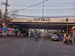
Talat Phlu

Talat Phlu or Talad Phlu (Template:Lang-th, pronounced [tā.làːt pʰlūː]) is a community and marketplace by the canal Khlong Bangkok Yai in Talat Phlu subdistrict, Thon Buri district, Thonburi side of Bangkok.
History and present
The history of Talat Phlu dates back to the reign of King Taksin of the Thonburi Kingdom, which followed the fall of Ayutthaya in 1767. At the time, the Thonburi side of the Chao Phraya river was the new capital of Siam (the name of Thailand at that time). Talat Phlu was a community of overseas Chinese or Thai-Chinese, also including Muslims and Mon. After King Rama I took the throne, establishing the Rattanakosin Kingdom, the capital was moved across the river to the Phra Nakhon side. Most of the Chinese moved to live in Sampheng, but some of them remained, descending to the present day.
The name "Talat Phlu" originated in the fact that in the past, this area contained vast phlu (betel) plantations owned by the Thai-Chinese, stretching along Khlong Bang Sai Kai to Khlong Bang Phrom and as far as Khlong Bang Waek. The collected phlu were sold in the area starting from the dyke in front of Wat Ratchakhrue to Wat Intharam, making the area the main wholesale market for mak (Areca catechu) and phlu, hence the name "Talat Phlu" ('betel market'). Today, although the planting of betel has disappeared, the name Talat Phlu remains.[1]
In its heyday (around 1950s–1960s), Talat Phlu was a bustling district, and it was said to be comparable to Yaowarat as one of Bangkok's Chinatowns.[2]
Nowadays, Talat Phlu is famous for its street food. In addition, there are many shophouses and buildings with delicate stucco and wooden fretwork decorations in Chinese style along the road beside the canal worth sightseeing.[2][1]
Area
The name "Talat Phlu" could be taken in a broad sense to encompass the areas of Talat Phlu (subdistrict), Bang Yi Ruea, Bukkhalo, Dao Khanong, it is more often used to refer to the subdistrict only.
Transportation
Talat Phlu can be reached by the State Railway of Thailand (SRT)'s Talat Phlu railway station on Mae Klong Railway Line.
The area is close to Talat Phlu BTS station on the BTS Skytrain's Silom Line, as well as Pho Nimit BTS and Wutthakat BTS stations.
Ratchadaphisek and Thoet Thai Roads are the main street of the area. Soi Phet Kasem 23 (Soi Punyalit Seni) is a shortcut to reach Talat Phlu from Phet Kasem Road in Phasi Charoen area.
References
- ^ a b Saengmanee, Pattarawadee (2018-01-24). "Take your tummy to Talat Phlu". The Nation. Retrieved 2018-03-03.
- ^ a b thepureway (2017-09-27). "Line กนก รากเหง้าหรืออำนาจเงิน ของดีย่านธนบุรี". Mthai (in Thai). Archived from the original on 2018-03-03. Retrieved 2018-03-03.
External links
- Tri-yasakda, Watsamon (2016-06-18). "Soi Food Series: Explore long legacy of street food at Talat Phlu". Coconuts. Retrieved 2018-03-03.
