Lashburn
Lashburn | |
|---|---|
Town | |
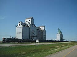
 Grain elevator in Lashburn | |
Location of Lashburn in Saskatchewan | |
| Coordinates: 53°07′26″N 109°36′47″W / 53.124°N 109.613°W | |
| Country | Canada |
| Province | Saskatchewan |
| Region | Saskatchewan |
| Census division | No. 17 |
| Rural Municipality | Wilton |
| Post office Founded | 1905[1] |
| Government | |
| • Mayor | Steven Turnbull[2] |
| • Town Manager | Vicki Seabrook |
| • Governing body | Lashburn Town Council |
| Area | |
| • Total | 3.11 km2 (1.20 sq mi) |
| Population (2011) | |
| • Total | 967 |
| • Density | 310.5/km2 (804/sq mi) |
| Time zone | UTC−7 (MST) |
| • Summer (DST) | UTC−6 (MDT) |
| Area code | 306 |
| Highways | Highway 16 |
| Website | Official website |
Lashburn is a town in Saskatchewan, Canada. It is located 35 km (22 miles) east of Lloydminster and 107 km (66 miles) west of North Battleford on the Yellowhead Highway, on the banks of the Battle River. It was founded in 1903 with the arrival of the Barr Colonists, led by Isaac Barr (an Anglican priest).

Main Street
Demographics
Canada census – Lashburn community profile
| 2011 | |
|---|---|
| Population | 967 (+5.8% from 2006) |
| Land area | 3.11 km2 (1.20 sq mi) |
| Population density | 310.5/km2 (804/sq mi) |
| Median age | 30.7 (M: 30.3, F: 31.1) |
| Private dwellings | 373 (total) |
| Median household income |
Notable people
- Henry Bonli (1927-2011), painter and interior designer
See also
References
- ^ "Post Offices and Postmasters (Lashburn)". Retrieved 2013-02-13.
- ^ "MUNICIPALITY DETAILS (towns)". Archived from the original on 2016-01-15. Retrieved 2013-02-13.
- ^ "2011 Community Profiles". 2011 Canadian Census. Statistics Canada. March 21, 2019. Retrieved 2013-02-13.
- ^ "2006 Community Profiles". 2006 Canadian Census. Statistics Canada. August 20, 2019.
- ^ "2001 Community Profiles". 2001 Canadian Census. Statistics Canada. July 18, 2021.


