Aighton, Bailey and Chaigley
| Aighton, Bailey and Chaigley | |
|---|---|
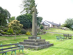
 Boer War Memorial at Hurst Green | |
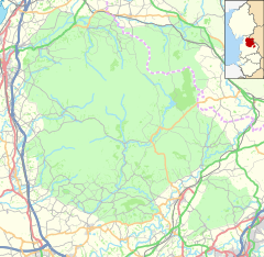
Location within Lancashire | |
| Population | 1,307 (2011)[1] |
| OS grid reference | SD6837 |
| District | |
| Shire county | |
| Region | |
| Country | England |
| Sovereign state | United Kingdom |
| Post town | CLITHEROE |
| Postcode district | BB7 |
| Dialling code | 01254 |
| Police | Lancashire |
| Fire | Lancashire |
| Ambulance | North West |
| UK Parliament | |
Aighton, Bailey and Chaigley is a civil parish in the Borough of Ribble Valley in Lancashire, England, just west of Clitheroe. The population of the civil parish at the 2011 census was 1,307,[1] an increase from 1,249 in 2001.[2]
The main settlements in the parish are Hurst Green and Walker Fold. Other places are Aighton, Bailey and Chaigley, originally three hamlets forming a township. Stonyhurst College is located near to Hurst Green, within the parish.
History
Aighton was mentioned in 1870 in the Imperial Gazetteer of England and Wales by John Marius Wilson, who wrote:[3]
AIGHTON, one of three hamlets forming a township in the parish of Mitton, Lancashire. It lies near Hodder river, under Longridge fell, 3½ miles NNW of Whalley r. station, and 5 WSW of Clitheroe. It contains cotton factories, a workhouse, and the Roman Catholic college of Stonyhurst. The other hamlets of the township are Bailey and Chaighley. Acres in the three, 5,780. Real property, £6,726. Pop., 1,500. Houses, 244.
Governance
Aighton, Bailey and Chaigley was once a part of the ancient parish of Mitton. This became a civil parish in 1866, forming part of the Clitheroe Rural District from 1894 till 1974.[4]
Aighton, Bailey and Chaigley also gives its name to a ward of Ribble Valley Borough Council. [5][6] The ward elects a single councillor, who currently is Janet Alcock of the Conservative Party.[7]
See also
References
- ^ a b UK Census (2011). "Local Area Report – Aighton, Bailey and Chaigley Parish (1170215092)". Nomis. Office for National Statistics. Retrieved 26 February 2018.
- ^ Office for National Statistics : Census 2001 : Parish Headcounts : Ribble Valley Archived 3 March 2016 at the Wayback Machine Retrieved 31 July 2010
- ^ Stringer, Phil (9 February 2005). "Aighton". GENUKI. Archived from the original on 29 March 2008. Retrieved 17 April 2008.
- ^ "Aighton, Bailey and Chaigley Hmlt/CP through time". visionofbritain.org.uk. GB Historical GIS / University of Portsmouth. Retrieved 16 April 2016.
- ^ "Aighton, Bailey and Chaigley". MARIO. Lancashire County Council. Retrieved 16 April 2016.
- ^ "Aighton, Bailey and Chaigley". Ordnance Survey Linked Data Platform. Ordnance Survey. Retrieved 16 April 2016.
- ^ "Councillors by Ward: Aighton, Bailey and Chaigley". Ribble Valley Borough Council. Retrieved 16 April 2016.
External links
 Media related to Aighton, Bailey and Chaigley at Wikimedia Commons
- Aighton in the Domesday Book


