Charing Cross Road
This article needs additional citations for verification. (February 2013) |

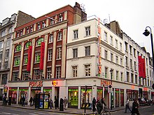
Charing Cross Road is a street in central London running immediately north of St Martin-in-the-Fields to St Giles Circus (the intersection with Oxford Street) and then becomes Tottenham Court Road. It is so called because it leads from the north in the direction of Charing Cross at the south side of Trafalgar Square, which it connects via St Martin's Place and the motorised east side of the square.
History
What is now Charing Cross road was originally two narrow streets in the West End, Crown Street and Castle Street. The development of Regent Street (parallel to the west) in the mid-18th century coincided with not only the building up of great fields west of the area but also Westminster Bridge which was built as central London and the wider estuary's second bridge after more than a century of pressure, in 1750.
These pressures therefore congested the north–south axis of the inner West End almost as much as the relieved London Bridge area. Specifically a major increase in traffic occurred around Piccadilly Circus, Charing Cross and Oxford Street, much of it destined from/to Tottenham Court Road, Bloomsbury and nearby routes to all northerly directions.
Charing Cross Road was therefore developed, in conjunction with Shaftesbury Avenue, by the Metropolitan Board of Works under an 1877 Act of Parliament.[1] The Act's total costs, including demolition and rebuilding of many rows of buildings across London was £778,238. The two streets and others such as the Thames Embankment, Northumberland Avenue and the Kingsway-Aldwych superstructure were built to improve traffic flow through central London.[2] The scheme abolished some of the worst slums in London which delayed progress in construction while they were rehoused.[1]
The new road met the disapprobation of Mervyn Macartney who said of it in an 1899 article: "Perhaps the worst is Charing Cross Road. It has no beginning and no end. Amorphous, hideous in its tortuous course, it is a monument of the ineptitude, parsimony, and incompetence of its creators."[3]
Bookshops
Charing Cross Road is renowned for its specialist and second-hand bookshops. The section from Leicester Square Underground station to Cambridge Circus is home to specialist bookshops, and more general second-hand and antiquarian shops such as Quinto Bookshop, Henry Pordes and Any Amount of Books. Smaller second-hand and specialist antiquarian bookshops can be found on the adjoining Cecil Court.

The northern section between Cambridge Circus and Oxford Street includes more generalist bookshops such as the venerable Foyles. A long-standing correspondence between New York City-based author Helene Hanff and the staff of a bookshop on the street, Marks & Co., was the inspiration for the book 84, Charing Cross Road (1970). The book was made into a 1987 film starring Anne Bancroft and Anthony Hopkins and also into a play and a BBC radio drama. 84 Charing Cross Road, located just north of Cambridge Circus, has not been a bookshop for many years; at street level it is now a restaurant (entered round the corner in Cambridge Circus), but the upper levels of the building remain as originally constructed. A small brass plaque, noted by Hanff in her book "Q's Legacy", remains on the stone pilaster facing Charing Cross Road.
Features
The music venue the Astoria was located here, as is one of the sites of St Martin's Arts College, opening in 1939.[1] To the northeast of Charing Cross Road are the music shops on Denmark Street (known as Britain's Tin Pan Alley).[4]
A number of theatres are on or near Charing Cross Road, such as the Phoenix Theatre (which has its entrance on the adjoining Phoenix Street), the Garrick Theatre and Wyndham's Theatre.[1]
Beneath the grille in the traffic island between Charing Cross Road's junction with Old Compton Street, in the middle of the road, the old road signs for the now-vanished Little Compton Street can be seen. This road once joined Old Compton Street with New Compton Street.
On the east side of the road's southern end, at the joining of St Martins Lane, is a statue of Edith Cavell. Towards the north end is the Phoenix Garden – an environmental garden run by local residents.
In the Harry Potter books, the Leaky Cauldron pub is located on Charing Cross Road. However, on screen, the locations used are Chez Michelle, a florist in Borough Market, for the exterior in Harry Potter and the Prisoner of Azkaban and the Glass House, an optician in Leadenhall Market, for the entrance in Harry Potter and the Goblet of Fire. Most interior filming was done on set.[5][6]
References
- Citations
- Weinreb, Ben; Hibbert, Christopher; Keay, Julia; Keay, John (2008). The London Encyclopedia. Pan MacMillan. ISBN 978-1-4050-4924-5.
{{cite encyclopedia}}: Invalid|ref=harv(help)
- Sources
- ^ a b c d Weinreb et al. 2008, p. 149.
- ^ Bradley, Simon; Pevsner, Nikolaus (2003). The Buildings of England. Vol. 6: Westminster. p. 401. ISBN 0-300-09595-3.
- ^ Macartney, Mervyn Edmund (June–December 1899). "From Holborn to the Strand: An Ideal Street". The Architectural Review. 6: 239-244.
- ^ Weinreb et al. 2008, p. 134.
- ^ The location of The Leaky Cauldron is implied in the earlier books but stated explicitly in Harry Potter and the Deathly Hallows; Chapter 26, page 423 Bloomsbury Edition, states "...He opened his eyes on Charing Cross Road. Muggles bustled past wearing the hangdog expressions of early morning, quite unconscious of the little inn's existence."
- ^ Jones, Richard. "Harry Potter Film Locations - London Gallery". Richard Jones's Free Harry Potter London Tour. Richard Jones. Retrieved 13 February 2017.
Further reading
- Book Lovers' London, by Lesley Reader, Metro Publications, paperback, 2nd edition, 2002, ISBN 1-902910-13-3; 3rd edition, 2005, ISBN 1-902910-26-5


