Getty Center Tram
| Getty Center Tram | |
|---|---|
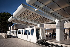
 A train at the Getty Center station | |
| Overview | |
| Locale | |
| Termini |
|
| Stations | 2 |
| Service | |
| Type | People mover |
| Rolling stock | 6 Otis Hovair vehicles (2 trains of 3 cars each) |
| History | |
| Opened | 1997 |
| Technical | |
| Line length | 0.75 mi (1.21 km)[1] |
| Operating speed | 14 mph (23 km/h) |
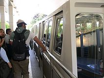
The Getty Center Tram is a 0.75 mi (1.21 km) people mover system that serves the Getty Center in Los Angeles. It runs two cable-driven hovertrains each consisting of three Otis Hovair vehicles.[1]
History
The tram line, already planned in 1988,[2] was opened at the end of 1997, following the inauguration of the Getty Center.
Route
The line, located north of Brentwood, in the Westside Region of Los Angeles, links a freeway-level parking garage to the Getty Center, which includes the J. Paul Getty Museum. The duration of a ride is about 3 to 4 minutes.[1]
The lower station (34°05′15.8″N 118°28′32.8″W / 34.087722°N 118.475778°W), at the bottom of the hill, lies beside Sepulveda Boulevard and the San Diego Freeway and features a refuge siding. The upper station (34°04′42.1″N 118°28′29.9″W / 34.078361°N 118.474972°W), at the top of the hill, is located in the arrival plaza of the Getty Center and is part of the structure.[3] The line follows Getty Center Drive and has a passing loop in the middle, although the two trains can operate independently.[4]
Gallery
See also
References
- ^ a b c "Getty Center Tram - Los Angeles, CA USA". Waymarking.com.
- ^ Krueger, Christopher (July 14, 1988). "Tram System Proposed for J. Paul Getty Center". Los Angeles Times.
- ^ 24563086 Getty Center Tram on OpenStreetMap
- ^ Simon, Richard (August 11, 1995). "The Art of Getting to the Getty Will Have Visitors Floating on Air". Los Angeles Times.


