Wusu
Usu
乌苏市 ۋۇسۇ شەھىرى | |
|---|---|
 Wusu CBD | |
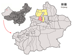
 Location of Wusu County (red) within Tacheng Prefecture (yellow) and Xinjiang | |
| Coordinates: 44°25′08″N 84°42′50″E / 44.419°N 84.714°E | |
| Country | People's Republic of China |
| Autonomous region | Xinjiang |
| Prefecture | Tacheng |
| Area | |
| • Total | 14,394 km2 (5,558 sq mi) |
| Population (2003) | |
| • Total | 210,000 |
| • Density | 15/km2 (38/sq mi) |
| Wusu | |||||||||||
|---|---|---|---|---|---|---|---|---|---|---|---|
| Chinese name | |||||||||||
| Simplified Chinese | 乌苏 | ||||||||||
| Traditional Chinese | 烏蘇 | ||||||||||
| |||||||||||
| Mongolian name | |||||||||||
| Mongolian script | ᠬᠦᠷ | ||||||||||
| Uyghur name | |||||||||||
| Uyghur | ۋۇسۇ | ||||||||||
| |||||||||||
| Kazakh name | |||||||||||
| Kazakh | وسۋ Shıhý Шиху | ||||||||||
Usu[1] as the official romanized name and transliterated from Mongolian, also known as Wusu, is a county-level city with more than 100,000 residents in Xinjiang, China. It is a part of Tacheng Prefecture of Ili Kazakh Autonomous Prefecture. Oil-production is a major part of the economy while the county is an oasis in the Dzungarian Basin. Wusu lies between the major cities of Bole and Shihezi in Northern Xinjiang and west of Ürümqi and Kuitun, south of Karamay.
Transport
Wusu is served by China National Highway 312, the Northern Xinjiang and the Second Ürümqi-Jinghe Railways.
Administrative divisions
Subdistrict (街道)
- Xinshiqu Subdistrict (新市区街道), Nanyuan Subdistrict (南苑街道), Xichengqu Subdistrict 西城区街道, Hongqiao Subdistrict (虹桥街道), Kuihe Subdistrict (奎河街道)
Town (镇)
- Baiyanggou (白杨沟镇), Hatubuhu (哈图布呼镇), Huanggong (皇宫镇), Chepaizi (车排子镇), Ganhezi (甘河子镇), Baiquan (Baychuan) (百泉镇, بەيچۇەن), Sikeshu (Chigshor) (四棵树镇, چىگشور), Guertu (Gürt) (古尔图镇, گۈرت), Xihu (西湖镇), Xidagou (Shidagu) (西大沟镇, شىداگۇ)
Townships 乡
- Bashisihu Township (八十四户乡), Jiahezi Township (夹河子乡), Jiujianlou Township (九间楼乡), Shiqiao Township (石桥乡), Toutai Township (头台乡)
Ethnic townships (民族乡)
- Jiergeleteguole Mongol Township (吉尔格勒特郭愣蒙古族乡), Tabulehete Mongol Township (塔布勒合特蒙古族乡)
Others
- Ganjia Lake Ranch (甘家湖牧场), Bayingou Ranch (巴音沟牧场), Saileketi Ranch (赛力克提牧场), Wusu Prison (乌苏监狱), Ganjia Lake Forest Area 甘家湖林场, 兵团123团, 兵团124团, 兵团125团, 兵团126团, 兵团127团, 兵团128团, 兵团130团
References
- ^ The official spelling according to Zhōngguó dìmínglù, 中国地名录 (Beijing, SinoMaps Press 中国地图出版社 1997); ISBN 7-5031-1718-4

